Significant new information has recently emerged concerning the location of the 1730 Mesquakie fort besieged by the French and their Indian confederates. The fort was the scene one of the most important battles in the colonial wars of New France. For more than one hundred years historians and archeologists have debated its location on the prairies of eastern Illinois. The new evidence includes an unpublished narrative of the siege, recovered in the spring of 1989 in Paris from the Archives Nationales. The account is that of Jean-Baptiste Reaume: interpreter, scout, and agent of French interests among the Nations of the River St. Joseph. In addition, during 1988 and 1989 an archaeological reconnaissance was made of 11-Ml-6. The preliminary results of this testing, while far from conclusive, point to the likelihood that this was indeed the site of this important event.
During August and September of 1730 the major conflict of the Second Mesquakie War was waged somewhere in the northeast quarter of Illinois. The lack of useful landmarks, conflicting contemporary accounts, and the poverty of eighteenth century cartography have contributed to confusion concerning its exact location. Involving a siege of approximately twenty-three days, 950 Mesquakie, 1400 French and Indian allies, a major victory for the French and a crushing death toll for the Mesquakie, it has been the object of recurrent historical speculation since at least 1865 (Ferland 1865:437; Peyser 1987).
The Mesquakie
This Native American society is known to itself as the Mesquakie or "People of the Red Earth." While there are variant spellings of the name, it is pronounced "Mus-quak-kie" (Kellogg 1908:142). Neighboring groups referred to them as the Outagami. The French more commonly employed the name Renard, which in English becomes Fox (Temple 1977:83).
The relationship between the Mesquakie and the French was never particularly good. The first direct French contact with the Mesquakie is recorded by Father Gabriel Druillettes in 1656 (Thwaites 1900:247). Father Druillettes reports that "The two Frenchmen who have made the journey to those regions say that these people are of a very gentle disposition." At the time of contact there may have been 1000 warriors (Temple 1977:84) with a total population of perhaps 2500. The French trader and adventurer Perrot was perhaps the only Frenchman to successfully interact with the Mesquakie. The exploitive and unscrupulous actions of a variety of coureur de bois permanently disaffected them from French culture. The Jesuits seem never to have made lasting inroads on the Mesquakie lifeway. The Mesquakie remain to this day a fiercely independent and deeply religious society.
In the first half of the eighteenth century the Mesquakie became embroiled in at least three major periods of conflict with the French. From the French perspective they consistently blocked French economic interests and spread dissention and conflict among the native peoples of the region. After the defeat of the Mesquakie at Detroit in 1712, they preyed upon the French and their Indian allies throughout the region of the upper country for four years. During the period from 1719 to 1726 the Mesquakie were again at war with the Illinois and, by virtue of this, the French. Their raids extended as far as Ft. de Chartres in southern Illinois. In 1726, in spite of a confused response on the part of the French, a formal peace was concluded.
By 1727 the French were again expanding trade contacts with the Sioux and other societies of the upper Mississippi basin. French success in this venture depended on water routes cutting through central Wisconsin and hence the heart of the Mesquakie homeland. The Mesquakie resisted this incursion. The French response during this final period of conflict was attempted genocide. This policy culminated with the Mesquakie defeat on the prairies of east-central Illinois after a twenty three day siege. By 1733 fewer than 100 Mesquakie remained alive (Tanner 1987:42).
McTaggart (1973:170-171) relates part of the Mesquakie oral tradition recalling this event. It provides some sense of the Mesquakie people and is recounted here in this spirit:
It was back about the same time that White Robe lived; it happened in 1732 [sic] in Illinois when the Mesquakies were surrounded in the forest. We were surrounded on all sides by other Indian tribes and by the French and we couldn't get away.
There were two leaders. And they took the sacred bundle and started leading a song, a sacred song. And they drummed and they sang and they chanted until the other side all fell asleep.
We had two runners, what you might call messengers. We don't have them any longer. And these two runners took a sacred wolf skin down to the river. And they were supposed to drag it lightly across the river to produce a fog.
But I guess they got overanxious in their duty and they dipped it in the water, dipped it in so that it was all covered up with water. On the top of it: they dunked it in the water. I guess they wanted to be sure that it would work. But instead it produced too much fog - a lot of rain and a lot of moisture in the air.
So while these people were all sleeping, the Mesquakies were to crawl away through this fog. As we were crawling over these sleeping bodies, we were being led by these two men who had taught us how to get away. One man's name was Mamasa: he was the drummer who had helped put the enemy to sleep. And the other man's name, I can't remember.
But as our people were crawling over the sleeping bodies, the fog was so thick that we couldn't see each other. So in the middle of the line, somebody lost a hand hold and we couldn't see each other, so one group went in one direction and the other group went in the other direction.
And the other group got lost from us.
While this narrative does little to pinpoint the location of the fort, it is intriguing in its own right. During this period the Mesquakie were surrounded and heavily out numbered by the French four times. On three of these occasions they were able to employ the weather (a fog, a rainstorm, and a snowstorm) to escape and survive (McTaggart 1973:174). Moreover, all of the French accounts of the siege remark on the singular nature of the storm that struck on the night of 8 September 1730. De Villiers states that it suddenly began an hour before sunset and lasted into the night "...so that, in spite of all I could say to our Sauvages, I was unable to make them guard all the outlets." (Thwaites 1906:117). Reaume's narrative adds that the Mesquakie "... made a large fire...." inside their fort that night and thus forewarned him of their escape plans.
French Accounts
While several documents which make reference to the siege are available in the published literature, only two may be properly considered primary accounts (Thwaites 1906:109-118). One is the official report filed by Lieutenant Nicolas-Antoine Coulon de Villiers, Commandant at the River St. Joseph and commander of the French forces. The other is an unattributed narrative authored by a Fort de Chartres source under the direction of Lieutenant Robert Groston de St. Ange. De Villiers' account is dated 23 September 1730. It was carried to Quebec by his son, Louis Coulon de Villiers, and the interpreter, Jean-Baptiste Reaume. They delivered it to Charles de La Boische de Beauharnois, Governor of New France. The Ft. de Chartres version is dated 9 September 1730 and was issued in New Orleans.
In the spring of 1989 a third narrative of the battle (see Appendix) was identified in the Archives Nationales in Paris, France. The existence of the document had been suggested in a letter to the Minister of Marine from Giles Hocquart, Intendant of New France. It is dated 14 November 1730 (Thwaites 1906:119-120). In the missive, Hocquart indicates an "annexed relation" of the siege based upon his interview of Jean-Baptiste Reaume, de Villiers' interpreter. Hocquart even allows that he had "...retained the expressions of the Sieur Reaume which are according to Canadian usage." (Thwaites 1906:120). Hocquart's suggestion that it "...contains some details omitted by Monsieur Devilliers." is accurate from the perspectives of both history and archaeology.
The document is dated 7 November 1730 and was issued from Quebec. It thus precedes Hocquart's letter by a week. From the first paragraph it is apparent that the informant and central character in the narrative is Jean-Baptiste Reaume, "...interpreter for the sauvages that dwell along the River St. Joseph." The account was transcribed by D'Auteuil de Monceaux. The document had been filed under a misspelling of his name. Auteuil, in a 1722 letter from Vaudreuil, Governor of New France, is accused of being an immoral consort to the marriage of Jean-Baptiste Reaume's brother, Simon (Peyser 1982:62). Both Jean-Baptiste and Simon play major roles in the account.
The three accounts agree in general chronology, offer useful detail on the natural setting of the site and the architecture of the fort, and the strategy and internal politics of the allied forces. In July, the Mesquakie had captured several Cahokias near Le Rocher (Starved Rock) on the River of the Illinois and had burned the son of one of their chiefs. Angered, the Cahokias sent runners to Ft. de Chartres seeking support. The Potawatomies, Kickapoos, Mascoutens, and Illinois had also been attacked by the Mesquakie. The Illinois had pursued the Mesquakie and found them marching in a body in the direction of the Ouiatanons (west-central Indiana). Upon contact the Illinois engaged the Mesquakie who took possession of a small grove of trees and therein fortified themselves. (The Reaume narrative is the only one to provide a distance and direction reference to the fort. The interpreter places the site 50 leagues southeast of Le Rocher.) The next day runners were sent to the Miami post and to the St. Joseph command to report the fort's location and direct their support. The Ft. de Chartres account indicates that the allied Indian forces had been awaiting aid for a month prior to the arrival of the French.
By 10 August St. Ange was moving north with 500 men and de Villiers southwest with 300. They joined with the 200 already present at the site. Another group of 400 Ouiatanons and Peanguichias under the command of Simon Reaume (Reaume Narrative) arrived the same day as de Villiers, bringing the total to about 1400 men at arms. St. Ange was the first to arrive (17 August) with the rest of the forces arriving shortly after 20 August.
According to the Ft. de Chartres narrative the Mesquakie fort was in:
... a small grove of trees surrounded by a palisade situated on a gentle slope rising on the west and north west side on the bank of a small river, in such manner that on the east and south east sides they were exposed to our fire. Their cabins were very small and excavated in the earth like the burrows of the foxes from which they take their name (Thwaites 1906:111).
For his part de Villiers offers the following description of the enemy's position:
The Renards' fort was in a small grove of trees, on the bank of a little river running through a vast prairie, more than four leagues in circumference, without a tree, except two groves about 60 arpents from one another (Thwaites 1906:115).
He also adds that the Mesquakie had ditches on the outside of their fort.
The Reaume account adds little to the description of the natural environment, suggesting only a woods located in a "... prairie as far as the eye could see." However, it provides some interesting detail on the fortification:
The Renards fortified themselves in their woods and the allies in the prairie a half a league from each other. The Renard fort was of stakes a foot apart, crossed at the top, all joined together and filled in with earth between them as high up as the crossing. On the outside a ditch ran around three sides with branches planted to hide it, with pathways of communication for the fort in the ditches and others that ran to the river. Their cabins were complete with joists covered with decking, commonly called straw mats (natter de paille). On top of this there was two to three feet of earth, depending on the cabin. There were covered ways such that one could see only an earthwork (terrasse) that would cast a shadow in the fort (Reaume Narrative).
The main encampment of St. Ange was to the south of the river. This group positioned three redoubts and attendant trenches so as to command the river and deny the Mesquakie access to water. De Villiers' primary encampment was to the northeast or north of the Mesquakie fort. His forces constructed two cavaliers on the high ground overlooking the fort, as well as an attack trench from which he hoped to set fire to the fort.
During the ensuing siege the allied forces were plagued with internal intrigues, shifting sympathies, and intertribal conflicts. The French alliance was a fragile one. On 1 September Nicolas des Noyelles arrived with 100 men from the Miami post. On 7 September, 200 of the Illinois deserted.
On the eighth of September a terrible storm blew up and as the Ft. de Chartres narrative records "...interrupted our work" (Thwaites 1906:113). The night was rainy, foggy, and very cold. The allied Nations refused to man their posts. Seizing this opportunity, the Mesquakie escaped from their fort. However, the crying of the children alerted the French sentries and their flight was discovered. Fearful that in a night engagement their own allies would fire upon them, the French command determined to wait until daybreak before launching their assault. At dawn, some eight leagues from the fort (Reaume Narrative), they rushed the exposed Mesquakie. Their ranks were immediately broken and defeated. The Reaume account further states that 500 were killed and 300 captured and that forty of the captured warriors were "burned." The Ft. de Chartres narrative adds that not more than 50 or 60 unarmed men escaped.
Maps and Sketches
At least six maps of the siege are known to survive, as well as a plan view of the fort with a number of appended details. The official map of the battle camp (there are two drafts) and the plan of the fort with the appended details are signed by Chaussegros de Lery (respectively titled Blocus du Fort and Plan du Fort des Sauvages). De Lery was the chief military engineer of New France and as such had responsibility for the official documents. De Lery's informants were de Villiers' son, Coulon, and the interpreter, Jean-Baptiste Reaume. These interviews occurred in Quebec when the two reported de Villiers' victory. The documents are variously dated 10, 11, and 15 November 1730.
The Ft. de Chartres narrative is associated with two maps (one a copy of the other) produced in New Orleans. They are titled Carte du Fort and are dated 26 March 1731. The legend indicates that it was based upon the officers reports. Nothing else is known about the production of this document, although it may have been generated by a royal engineer of Louisiana. Engineers doing this type of work at the time include Pierre Baron, Ignace Francois Broutin, and Francois Saucier (see Saucier and Seineke [1969] and Wilson [1969] for discussions of their careers and work).
Peyser (1987) has offered an extensive analysis of the two remaining charts.
In light of the Reaume account, Fort des Renards and Sauvages Renards
Attaques seem circumstantially associated with it. The references in the
narrative correspond to those of the maps, placing as they do a singular
emphasis on the roles of the Reaume brothers. It should be noted, however,
that while the Hocquart communication makes reference to an appended narrative
it makes no mention of a map. Neither is signed or dated. Consequently, how
these maps found their way to the records of the Minister of Marine remains
open.
The present author has previously discussed the enigmatic variation found
between these several drawings with regard to the basic geometry of the fort
(Stelle 1989). In further addressing this difficulty some new perceptions and
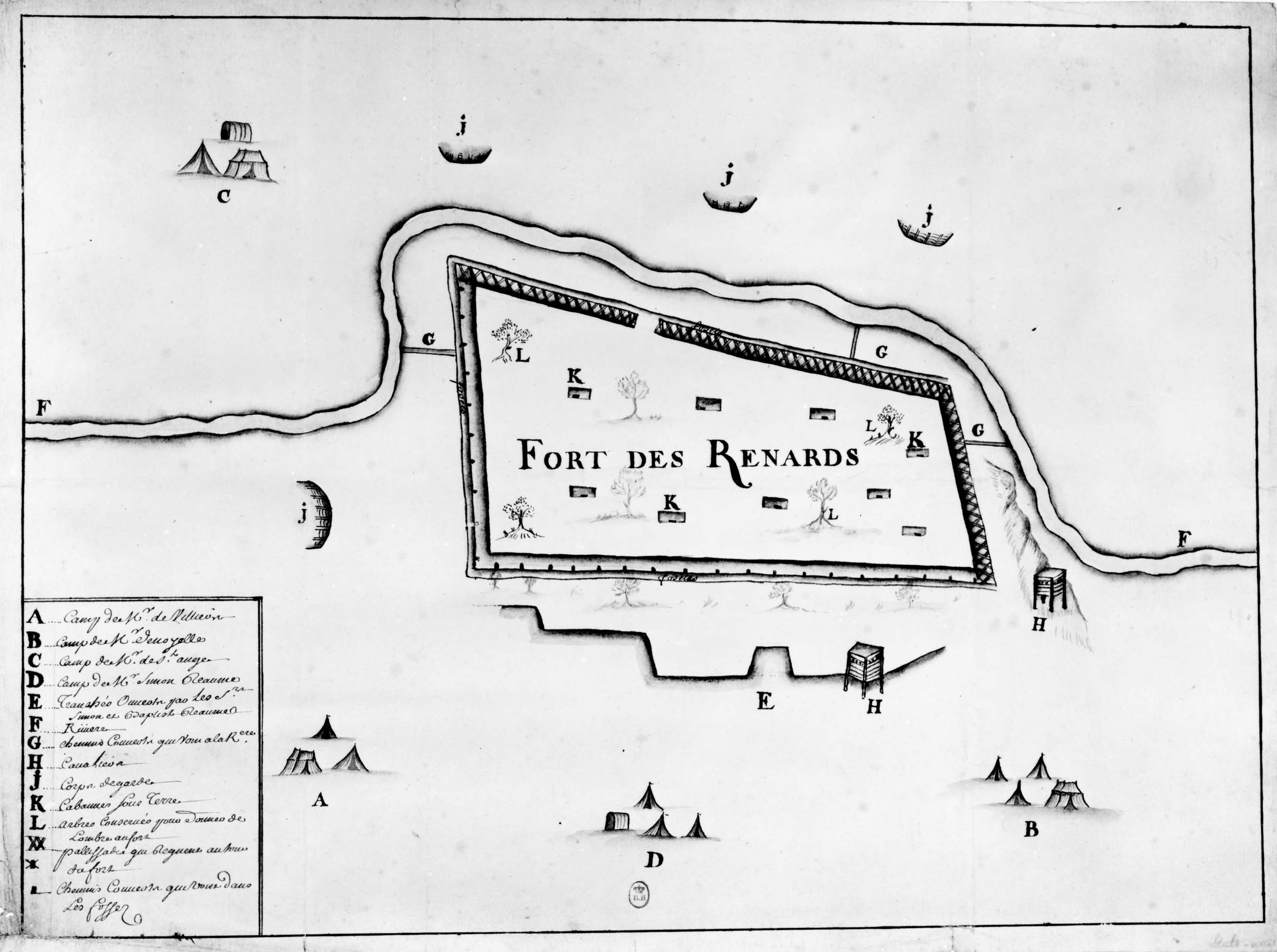
possibilities have emerged. The Fort des Renards and the
Sauvages Renards Attaques (Figures 6-1 and 6-2 respectively) appear
related not only in historical perspective but also with regard to artistic
representation. Peyser (1987) views the Fort des Renards as the
simpler, less complex document. Expanding on that observation, it could be
that it is the original drawing and Sauvages Renards Attaques is an
edited, more detailed, and more stylized rendering. In the absence of
historical information to the contrary, one might speculate that the original
may even have been produced at the site. In any event, it is clearly a model
for the Sauvages Renards Attaques. To observe these similarities one
must first properly orient the Fort des Renards document
by turning it upside down (north is not indicated) and secondly, the
Sauvages Renards Attaques must be enlarged by 122% (no scale is indicated
on either drawing). By then superimposing the two documents one discovers that
(1) the positions of the St. Ange battlements are plotted in the same exact
positions relative to the river, (2) the encampments of de Villiers, des
Noyelles, and Simon Reaume are in the same exact locations, (3) the
encampment of St. Ange has been shifted up approximately 1.5 cm to accommodate
the space reserved for the key, and (4) the renderings of the fort proper
display a fundamental coincidence, one neatly tucked within the other.
Additionally, while the author(s) of the documents remain unidentified there is
an unmistakable similarity in drawing style, layout, and technique of the key.
In spite of the intriguing linkages suggested in the foregoing discussion,
which representation of the fort is correct remains unknown. The methods of
historiography fail to provide an answer to this critical issue. The real
promise of archaeology for history is that answers to questions of historical
speculation are potentially available in the ground and can be determined upon
the application of proper archaeological technique. In this case, the validity
of the drawings has potential for empirical determination. Proposed Locations The same consideration applies to the actual location of the fort. As
previously indicated, the poverty of colonial cartography and the absence of
useful landmarks on the prairie has left the answer to this question
problematic. At least ten tracts are offered in the literature as the site of
the fort [see Peyser (1980:208) for a summary discussion]. Authors have chosen
their locations on the basis of their perceptions of the veracity of the
historical documents and their interpretation of distance and direction
measurements. All of the distance and direction references are generalized and
presumably reflect surface rather than statute distances. This ambiguity has
left much room for historical speculation.
Of the three narratives, only the newly surfaced Reaume Narrative provides a
distance and direction reference. The other two are surprisingly silent with
regard to this central fact. Reaume indicates that the Mesquakie were found
"...50 leagues southeast of Le Rocher."
Figure 6-1. Fort du Renards. Note the generally primitive quality of the drawing and the absence of a north arrow and scale. The present author argues that it was the model upon which Sauvage Renards Attaques was constructed.
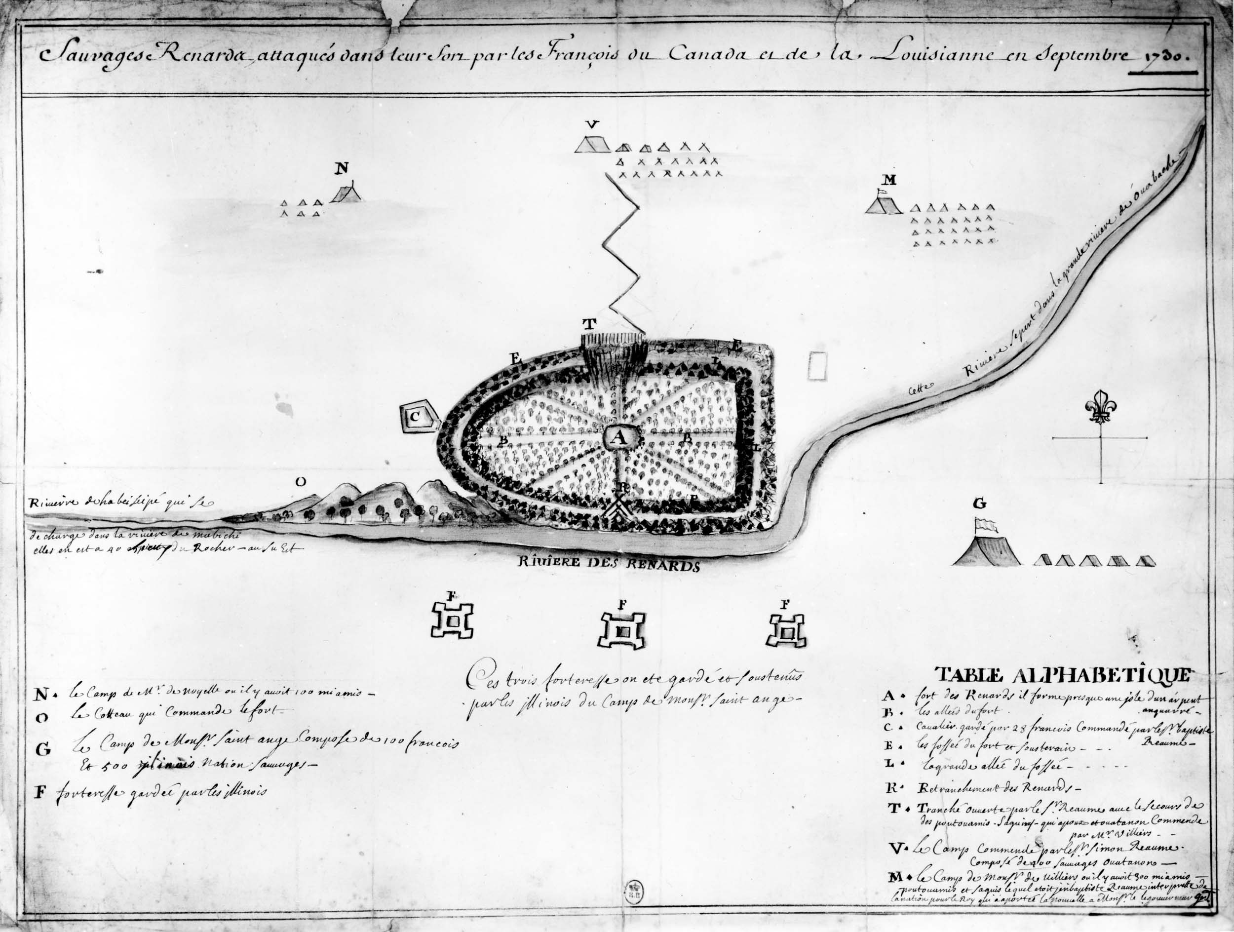
Figure 6-2. Sauvages Renards Attaques. Undated and unsigned, it is attributed to the Reaume Narrative by the present author.
The three statements that researchers have heretofore relied upon are: (1) the legend of de Lery's Blocus du Fort and Plan du Fort des Sauvages; (2) a letter from Hocquart to the French Minister of Marine, dated 15 January 1731; and (3) a detail in the map Sauvages Renards Attaques. De Lery indicates that the fort was located 50 leagues east southeast of Le Rocher. Hocquart's report states "...in a plain situated between the River Wabache and the River of the Illinois, about 60 leagues to the south of the extremity or foot of Lake Michigan, to the east-south-east of le Rocher in the Illinois Country" (Thwaites 1906:129). Lastly, the detail on the Sauvages Renards Attaques chart indicates that the fort was located on the River of the Renards or the Beiseipe River which flowed into the Mabichi River. The Mabichi, in turn, emptied into the Greater Wabash. The detail further adds that this river system extended to within 40 leagues of Le Rocher and was located to the southeast.
What seems consistent about these four descriptions is a location southeast or east southeast of Le Rocher some 40 to 50 leagues in a then unmapped region of Illinois. With river systems uncharted at the time and river names unrecognizable today, these referents are of little direct use. Even if one could be certain of the drainage, pinpointing the fort would remain difficult. Obviously, we have an ambiguous situation.
As indicated earlier, several sites have already been presented as possible locations using historical argument and speculation. Having reached the likely limits of this epistemological technique we reassert our earlier contention: which, if any, is the actual site is an empirical question, answerable through archaeology.
One of the several sites to receive attention in the literature is located on the eastern boundry of McLean County, Illinois. It (Figure 6-3) is referred to by (John?) McGregor in 1947 as the Arrowsmith Battle Ground (11-Ml-6). Because of the unique qualities of Ml-6, it was judged a good site at which to begin seeking answers to our questions.
The appellation, Arrowsmith Battle Ground Site, seems a bit cumbersome and somehow too romantic for standard usage. It does suggest McGregor's willingness to concede that an armed engagement occurred on the site. He was apparently unable to associate it with the Mesquakie and the French. A search for relevant notes or data has, to date, produced no results.
Environmental Description
Ml-6 is situated on the headlands of the Sangamon River. The GLO township survey maps of 1841 indicate that the river became intermittent less than four statute miles to the southwest. The documents show the river passing through seven sections before turning to the southeast. It then extends another thirty miles before turning back to the west. The river rises between two of the recessional moraines associated with the Peoria Sublobe of the Woodfordian Glaciation. The deposition would have occurred between 14,000 and 15,000 years ago (Willman and Frye 1970:94). The presumed location of the fort is upon the crest of a small knoll 250 meters east of the confluence of an unnamed tributary. The valley carved by the tributary is 150 meters wide where it drops to the floodplain of the river.
The little knoll is an element of the Sangamon's north valley wall. The wall rises in a relatively abrupt fashion in this place to an elevation 5 m above the floodplain. Its drainage and slope is generally northwest to southeast. The terrain lying about the knoll is described by the GLO surveyor, John Barcroft, as "broken" (Barcroft 1841). To the northwest of the site, the land evidences a few, small ice-contact features of higher elevation. To the north and northeast, the land assumes a gentle roll. It gains elevation and crests on the Normal Moraine some several kilometers to the north. Across the river to the south, southwest, and southeast, the floodplain is quite wide and level. There is no well defined valley wall in these directions. Approximately 2 km to the south one encounters the crest of the Bloomington Moraine.
An examination of the soils suggest stratified sands and gravels of glacial outwash covered with a thick mantle of loess. They are often quite eroded. Barcroft describes the soils in 1841 with references like "gravelly, poor, and second rate" (Barcroft 1841). The soils were most recently surveyed in February of 1988 (McLean County Soil Conservation Service, personal communication) and form a Saybrook silt loam (1 to 4 percent slopes) and Drummer silty clay loam association on the uplands. The valley wall is an eroded 5 to 10 percent slope and is identified as LaRose silt loam. The floodplain alluvium is typically Sawmill silty clay loam. These prairie soils are quite acid and contribute to poor faunal preservation.
The floristic communities of the site would have been dominated by the Dry-mesic Upland Forest and the Mesic Prairie (see White and Madany [1978] for greater detail on the natural communities of Illinois and Stelle [1987:17-24] for their expression in the upper Sangamon basin). Of significance here was a fifteen acre, oak-hickory timber. Known as Small Grove or Smith's Grove, less than two acres survive. The grove was so small and centrally located in Section 24 that it failed to receive mention in Barcroft's field notes. A little island of timber surrounded by a sea of grass, it could likely have been the most upstream manifestation of the corridor forest bordering most of the length of the Sangamon River. The Mesic Prairie community would have dominated the encompassing landscape. The floodplain might properly be viewed as a tall grass, prairie slough through which coursed a slow, shallow Sangamon River. The surrounding uplands would have displayed more xeric elements of this association.
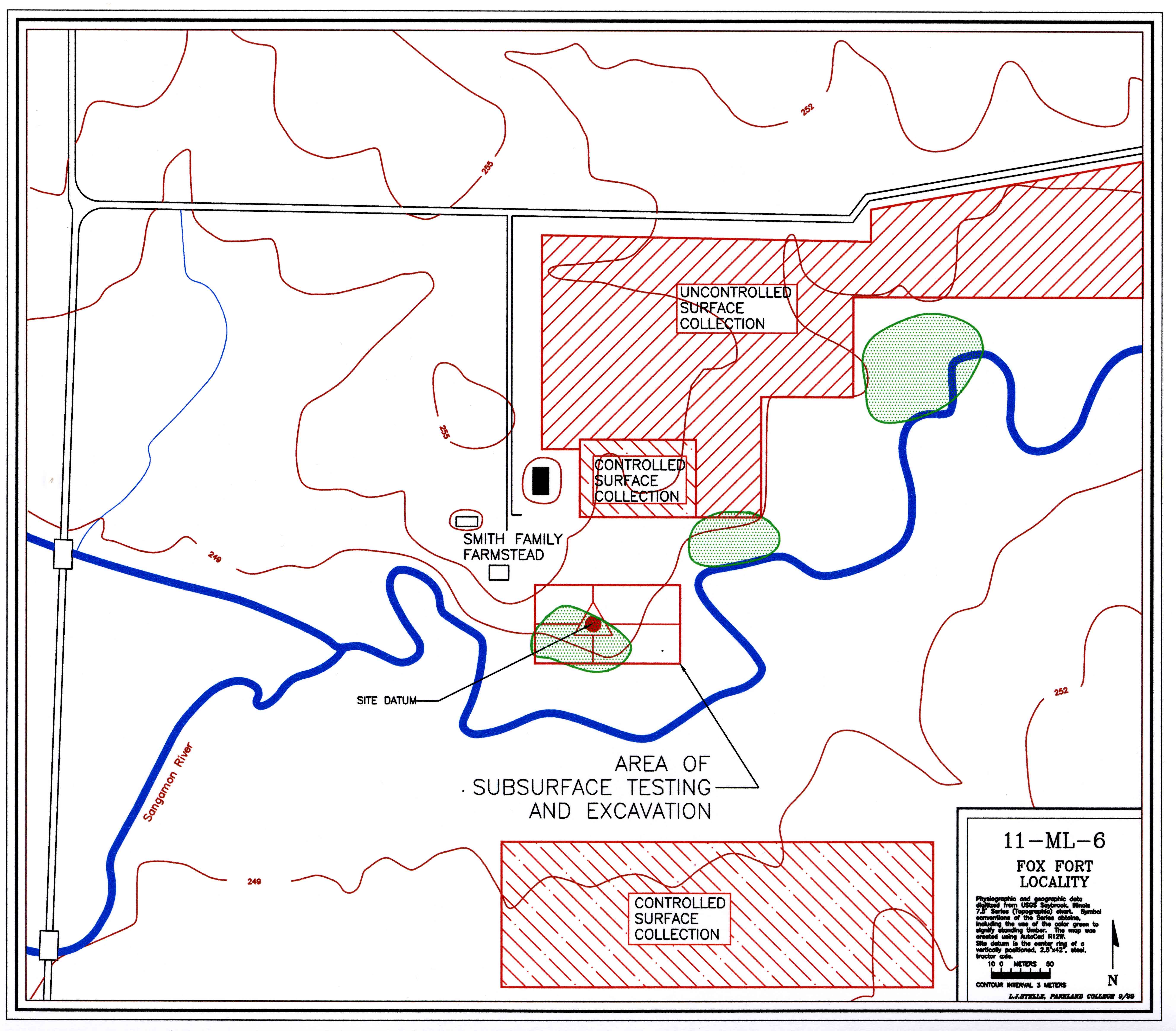
Figure 6-3. The Arrowsmith Battle Ground Study Area (11-Ml-6).
Previous Research
Among the sites that have been offered as the location of the siege, Ml-6 is unusual in that it has been the object of two earlier "archaeological" investigations: one by Captain John Burnham in 1897 and the second by William Brigham in the 1930s. While a few recent authors have accepted the interpretations of these studies (Tanner 1987:42), more have equivocated (Callender 1978:644; Temple 1977:90), and most have remained unconvinced (Peyser 1980:208; 1987:154). The issue has at times been so clouded that the editors of a 1960 Illinois Archaeological Survey publication felt the need to follow one of Brigham's articles with a five page statement (Bauxar 1960:101-106). A review of the two reports is warranted.
In May of 1897, Captain John Burnham (1897;1908) in association with "...several pioneers of eastern McLean County and a few members of the McLean County Historical Society...." excavated "...four or five of the dozen or fifteen of the pits...." located on the crest of the knoll. While he fails to differentiate their recovery from objects "presented" to them, he lists 200 lead balls; a few arrowheads or points; charcoal and ashes; bones of animals; knife blades (one bearing the maker's mark, Pierre Minan); a lock from a flint lock; parts of two gun barrels each of which had been flattened on the ends; pieces of copper ornaments; pieces of nearly straight "deer-horn prongs"; and several pieces of iron. All of these objects are now lost.
With regard to the features they excavated, no maps or drawings are recorded. He states that the "pits" were irregularly spaced and shaped. They first dug into the ridges surrounding the depressions (mostly clay or sub-soil) and found them devoid of material. Turning next to the depressions, they found them rich in material with bottoms two to three feet below the natural level of the ground. The largest was fifteen feet in diameter at the top and eight or ten feet at the bottom. All contained "mostly" animal bones (poorly preserved), ash, and charcoal.
Burnham also relates descriptions of zig-zag earthworks lying some 825 feet to the northeast of the knoll. These structures had been plowed to obscurity by the time of Burnham's visit.
The second published account that involved excavation was by William Brigham (1936), who visited the site in 1932 and 1934. The 1934 dig was done in association with the McLean County Academy of Sciences. Both visits were likely one day affairs. At least another ten pits were exposed by a trench dug across the hill in a northerly direction. Importantly, Brigham's indication that the 1934 event was "A more systematic investigation than any of recent years...." (1936:37) suggests that serious collecting from this site was an ongoing process. The 1932 probes yielded charcoal, bones, teeth, an arrow (?), and a bullet. The 1934 trench provided worked soil, bones, charcoal, a piece of sheet copper, a number of bullets, and a short section of gun barrel. The artifacts illustrated in the report may include the material recovered, but certainly include much undescribed and unprovenienced data as well. Some of the artifactual material attributed to this effort is reposed in the collections of the McLean County Historical Society (Martin Wyckoff, personal communication).
In summary, several observations are in order. First, this is the only proposed site of the fort for which any archaeological information is available other than Steward's "old French battle axe" and "French gunflint" (1908:255) from Maramech Hill. Second, Brigham's efforts removed the last of the original deposition visible from the surface. The "pits" that can be seen today are the product of large scale and unreported looting. Clearly, if the site only consists of a single, twenty-three day occupation it is at considerable risk of being destroyed. Thirdly, the poor, if understandable, quality of these two studies renders any archaeological inferences suspect. The information about the general location and nature of features and about the relative abundance of musket balls seems credible. One can reasonably conclude that some sort of military engagement transpired here in the eighteenth century. However, these studies fail to provide adequate archaeological support for their inferences regarding the identities of the combatants or a more specific temporal context. In conclusion, given the site's potential importance to the history of the region, its limited deposition, the potential yield in information regarding a major armed struggle, and the vague quality of the existing research, an archaeological reconnaissance was initiated.
Research Goals
As has been suggested by the foregoing discussion, the basic goal of the present work is to conduct an archaeological reconnaissance of this locality and to establish base line data from which culture-historical inferences can be made and resource management recommendations based. Ml-6 has the potential to yield answers to a variety of research questions focusing on how regional Native American social systems functioned during periods of critically high stress. This is true regardless of the identities of the combatants. Questions of interest might include (1) fortification design and construction, (2) religious and ceremonial activities, (3) dietary considerations, (4) both internal and external economic interactions, (5) production trajectories associated with war materiel, (6) enhanced estimates of the sizes of family units based on the dimensions of domestic architectural units, (7) medical practices centering on the care of the wounded, and (8) mortuary practices. The prospect of being able to address such questions at this site makes it unique. By comparison, the nearby Kickapoo Fort at the Warren Bane Site fails to provide evidence of military operations or siege conditions (Smith 1978).
In answering these questions a secondary set of issues can also be addressed. This study is obviously concerned with the prospect that Ml-6 is the site of the 1730 siege of the Mesquakie. In which case the site must demonstrate the presence of the Mesquakie, the French, the fort, and temporally sensitive data centering on a 1730 horizon.
Lastly, the reader is advised that Ml-6 is potentially a very large site and we have only just completed our second season on it. What is offered by way of results must be viewed in a tentative fashion and as a report on work in progress.
Data Collection Techniques
The data collection techniques employed consist of six distinct elements (Figure 6-3):
1. An infrared aerial survey of slightly more than the northwest quarter of Section 24;
2. An initial uncontrolled surface collection of cultivated farm lands (surface visibility >95%);
3. A controlled surface collection of cultivated farm lands where artifactual material was encountered during the uncontrolled collecting (collection units were 20 m x 20 m, transects were on 3 m intervals, and all recovered items were piece plotted);
4. A shovel probe survey based on a grid interval of 2 m over the top of the knoll thought to be the location of the fort (this ground is either in improved pasture or alfalfa with surface visibility <5%);
5. A metal detector survey sweeping the north-south and east-west lines of the collection grid (see the following discussion regarding sampling design);
6. A total of twenty-four test excavations, four of which were 2 meters square, fifteen were 1 m x 2 m, and the balance were 1 m x 1 m.
The test grid for the shovel probe and metal detector surveys necessitated a sampling design. Focusing on the top of the knoll described as the locality of the fort, we arbitrarily established a grid 150 m east-west and 80 m north-south. Working on 2 m centers, a random sample of approximately 5.4 percent of the grid intersects were selected for probing (N=165). This was achieved by choosing 15 north-south lines and 11 east-west lines. By selecting the sample in this fashion greater control could be realized in locating the collection points and the metal detector sweeps could use the identified lines as transects.
The controlled surface collecting occurred wherever the land afforded visibility greater than 95 percent and whenever human resources were available. This activity was seasonally adjusted to crop production.
The test excavations were initially positioned in response to the discovery of subsurface deposits identified by the shovel probes.
Results
The infrared survey, consisting of three flights, has yielded no positive results. This approach was employed in hopes of being able to locate some of the outlying elements of the battle camp (the defensive positions of the French and Allies) if such existed.
The uncontrolled surface collection centered on cultivated fields lying to the north and northeast of the fort location. No pre-1850 diagnostics were recovered.
The controlled surface collecting involved 24 collection units organized in a block 80 m x 120 m lying north of the fort area and east of the existing farm house. A large scatter of 1850 to 1900 material was identified as well as a small concentration of prehistoric lithics.
The shovel probe survey is 48 percent complete, 79 of the 165 intersects have been dug. The analysis and evaluation of the survey must await its conclusion. It is important to note that of the 79 probes, only four indicated distinct subsurface deposits. If the fort was in this location, the residues must be highly localized.
The sweeps of the selected grid transects were completed using a Brinkman Sensor 5000 T/R metal detector. The most frequent recovery categories were wire nails, fence wire, and pieces of farm machinery. The only possible eighteenth century metal identified were two musket balls.
The twenty-four test units (Figure 6-4) involved excavation of fifty-one square meters of surface. They yielded information on a number of features including seven structures and five connecting ditches.
Findings and Discussion
Features.The discussion of features will be limited to the seven semi-subterranean structures and the five connecting ditches (Figure 6-4). None of the features was completely removed. Minimally, 15% was preserved.
(1) Structure #1 was first encountered at grid coordinates N25, W0. At the base of the plow zone (25 cm bs), it is a roughly oval area 2.8 meters north-south and 1.8 meters east-west. The bottom of the structure is 1.9 meters by 1.4 meters. The structure's floor (Figure 6-5) is essentially level with a depth of 40 to 45 cm below surface. The ground surface may be 5 to 10 cm below its original contour due to the effects of plowing and the attendant down slope movement of A horizon soils. The northwest margin of the feature basin revealed a series of seven post molds, 4 to 6 cm in diameter, and on approximately 20 cm centers. Three extended down more than 40 cm. The southwest quadrant of the structure's floor revealed a ring of hearth stones with considerable evidence of in situ burning. The feature fill consisted of a matrix of very dark gray (10YR 3/1) silty clay. The fill included significant quantities of charcoal, ash, and very poorly preserved fragments of faunal material. Typical of all the structures was a lamination lying 5 to 10 cm above the basin floor. Having a maximum thickness near the margin and pinching off toward the center, the lamination contains 10YR 4/4 silty clay mottles in a 10YR 2/2 matrix. Some of the mottles are burned. Charcoal is conspicuous and is most dense at the bottom. The lamination is interpreted as a burned roof system. Artifactual material from below the plow zone included two grit tempered sherds, five musket balls, a lead cinder, and a brass tinkling cone. This structure is separated from Structure #2 by a distance of less than 2 m.
(2) Structure #2 centered on grid coordinate N24, W2. This feature is also roughly oval in outline. The dimensions of the basin can only be estimated because less than one half was exposed. At the base of the plow zone it was 2.4 m long and 2 m wide and at the bottom of the unit 2.1 m by 1.6 m. The longitudinal orientation of the structure was northwest to southeast. The floor of the structure was also quite level with values ranging between 53 and 58 cm below surface. Of interest was the presence of four charred sticks (20 to 25 mm wide and up to 12 cm long) lying along and perpendicular to the west margin of the floor and spaced at regular intervals (20-25 cm). They are interpreted as elements in a burned support or rafter system. The matrix consisted of very dark brown (10YR 2/2) clay loam. Measurable amounts of charcoal, ash, and bone were identified. The artifactual recovery included eight seed beads, three fragments of a tinkling cone, two small pieces of sheet brass, three musket balls, a triangular bar of lead, and a small cube of galena.(3) Structure #3 was encountered at grid coordinates N8, W2. At the base of the plow zone, its dimensions were 227 cm north-south and 265 cm east-west. The longitudinal axis was northwest to southeast. As is the case with the Structure #4, the walls sloped inward and the floor had two levels: one at 60-62 cm and the other at 79 cm below surface. Owing to the fact that the test unit was associated with a fence line, the depth measurement may more accurately reflect the actual depth of the original structures. The matrix (Figure 6-5) consisted of homogeneous very dark brown (10YR 2/2) clay loam containing charcoal, ash lenses, burned clay, and some bone. A lamination in the feature fill contained significant amounts of charcoal and clay mottles that had been fired, pointing to the likelihood that the structure had an earth covered roof that had been burned. A concentration of ash, charcoal, and in situ fired clay along the southwest margin of the upper level of the floor suggests the presence of a fireplace. The faunal recovery from this unit was significantly greater than any of the other structures. Identified elements include Bison bison, Ursus americanus, and Canis familiaris. The association of a bear canine and a large fossil of horn coral imply religious or ceremonial functions. The cultural material from below the plow zone included (1) a cube of galena, (2) seven musket balls, a lead BB, and two globules of melted lead, (3) all or part of three French gunflints and two of native manufacture, (4) two small, triangular pieces of sheet brass, (5) a relatively large piece of sheet brass and three small fragments, (6) two brass tinkling cones, (7) two Madison Points, (8) the stem of an Early Archaic biface, (9) utilized flake tools, (10) chert debitage, (11) a hammer stone, (12) two small fragments of iron, (13) a sherd of grit tempered pottery, (14) a large fossil of horn coral, (15) three bone tools, (16) a preserved section of animal hide, and (17) several small fragments of cattail vegetable fiber matting. The immediate association of the bone tools, animal hide, and vegetable fiber with the large piece of sheet brass contributed to their preservation. Indeed most of the sheet brass had preserved matting associated with it. The matting was recovered on both upper and lower surfaces of the brass. The recovered debris suggest the possibility that stone arrowheads, brass arrowheads, and musket balls were being produced in this structure.
(4) Structure #4 was identified a grid coordinates N25, E9. At the base of the plow zone its dimensions were 105 cm north-south and 255 cm east-west. The truncated basin displayed two floor levels: one at 45 cm below surface and the other at 60 cm below surface. Along the northwest margin of the lower level a concentration of charcoal, ash, bone, and clay baked in situ indicated the location of a fireplace. Indications that the structure was burned are found in the lamination in the feature fill interpreted as the roof. They include large quantities of charcoal and fired clay mottles. Structure #4 provided good evidence of the system used for supporting the roof. In the northeast quadrant, at 50 cm below surface, a series of post molds 30 mm to 40 mm in diameter and 40 mm to 60 mm apart were formed in the margin of the basin. The structure had ditches radiating on the south and west sides. Tracing out the one extending to the south (Ditch #4) led to Structure #7. Cultural material recovered from the structure below the plow zone included two sherds of grit tempered ceramic and two musket balls.
(5) Structure #5 was first encountered near grid coordinates N24.4, W7. It was located by following Ditch #1. Explored with only a meter wide trench, all that can be observed is that opposing walls were 210 cm apart along an east-west axis and that the maximum depth of the feature fill was 82 cm below surface. In fact, Structure #5 remains rather enigmatic. Near its center and ranging from 35 to 60 cm below surface was an articulated Canis skeleton. A Madison point was removed from the shoulder area. The skull was not located. The back was curved so that the neck pointed north and the tail east. The depositional sequence associated with the dog has not been determined. A second concentration of bone was identified to the west and below the dog remains. The feature fill was a very dark brown (10YR 2/2) silty clay loam. The roof lamination contained much charcoal, ash, and small amounts of burned clay. The structure is interpreted as having been burned. Artifactual material from below the plow zone included a clasp knife, a small iron object, and the Madison Point.
(6) Structure #6 was identified by following Ditch #2 to N29.4, W3.2. The 1 m x 2 m test excavation failed to reveal an opposing wall. The bottom of the feature was reached at 53 cm below surface. Near the center of the test unit a semi-circle of rocks and an abundance of charcoal, ash, bone, and in situ burned clay indicated the presence of a fireplace. The roof lamination was present with the typical inclusion of charcoal, ash, and fired clay mottles. A variety of artifactual material was recovered: a gunflint of native manufacture, two iron objects, five pieces of sheet brass, the base of a sheet brass arrowhead, a brass tinkling cone, and a lead "whizzer." The faunal remains included Canis. Two of the pieces of sheet brass, collected from the floor of the structure (51 and 53 cm below surface), had preserved cattail matting. Stratigraphically, the matting was found both above and below the brass objects.
(7) Structure #7 was located by tracing out Ditch #4 to near N21.75, E9.5. A one meter square test unit confirmed the presence of the structure. Horizontal dimensions and orientation could not be discerned. Maximum depth in the portion excavated was 63 cm below surface. The roof lamination was present in the feature fill, however it is not clear if the structure was burned. A patch of in situ burned clay from below the floor of the structure hinted at the location of a fireplace. Artifactual material included two Madison Points, a bowl fragment from a catlinite pipe, a lead "whizzer", a copper "C" bracelet, a musket ball, and a large iron tool.
(8) Ditch #1 was first encountered at N29, W0. The side walls of the
test excavation revealed a trench 37 cm wide running at an angle 69 degrees
east of north. The feature was exposed for a distance of seven meters. The
maximum depth was 57 cm below surface. No cultural material was recovered from
below the plow zone. The ditch terminated in Structure #5.
(9) Ditch #2 was identified at N29, W2. The area of disturbance was 63
cm wide and extended to 37 cm below surface where it was truncated by Structure
#6. Less than one meter of its length was exposed. No artifactual material
was recovered from below the plow zone.
(10) Ditch #3 was identified issuing from the west side of Structure #4
(near N25, E7). Less than 20 cm of its length was exposed. It reached to a
maximum of 45 cm below surface. No artifactual material was recovered below
the plow zone.
(11) Ditch #4 was less than 3 m long and connected Structures #4 and #7
passing through grid coordinates N24, E9. It extended to a maximum of 70 cm
below surface. Unlike the other ditch features, Ditch #4 had a activity area
located approximately half way between the two terminating structures. This
area was defined by a small bulge in the wall lines of the ditch, by the
presence of a bone and charcoal concentration, and by the presence of
artifactual material. Artifacts recovered from below the plow zone included
three Madison points, a lead "whizzer", and a musket ball.
(12) Ditch #5 extends west out of Structure #2 (near N23.5, W4). It is
43 cm wide at the base of the plow zone and reaches a maximum depth of 49 cm.
Approximately one meter was exposed. No artifactual material was recovered.
Extending the line of the ditch one encounters Structure #5 approximately 3 m
to the west.
Summary - The architectural and design elements of Ml-6 are quite
distinctive. Excavation has exposed seven semi-subterranean structures. They
are often oval in plan view reaching a maximum length of 2.6 m at the base of
the plow zone. The basins have a maximum depth of 82 cm below surface.
Several activity areas can be identified including food preparation and tool
production. Five of the seven demonstrated a differentiated use area for a
fire. All of the hearths contained bone.
The roofing system of the structures seems to consist of three elements:
rafters, cattail mats, and banked earth. Structures #1, #2, and #4 offer the
best evidence of bearing elements or rafters. One might speculate that a pole
was placed in the ground at 30 cm to 40 cm below surface and then tied off to
one on the opposite margin of the structure thereby creating an arch. Lashings
could then have been placed at each intersection of rafter material. Such a
configuration would have produced a very strong grid work stabilized by the
weight of the cattail mats and thick layer of earth. The cattail matting
preserved in Structures #3 and #6 includes specimens where the matting is
present on both the upper and lower surfaces of the horizontal brass object.
One interpretation would be that matting was employed on both the ceiling and
floor. Smith (1928:269-270), in his ethnobotany of the Mesquakie, indicates
that Typha latifolia, cattail, was sown into large mats and used
as the exterior cover for the Mesquakie winter homes. The distinctive clay
mottled lens in the feature fill suggests an exterior sheathing of banked dirt.
The lens is typically 15 to 20 cm thick but is variable suggesting that the
sheathing was thickest at the base and tapered to the peak. All but perhaps
one of these structures were burned. In the historical literature the Reaume
Narrative and the details on De Lery's Plan du Fort
indicate that the Mesquakie had constructed shelters in the ground with a
rafter system supporting first a deck of "straw mats" and then two to three
pieds (12.8 English inches = one pied) of earth. The data would
seem to support this description.
Several of the structures were connected by ditches, a design element also
described in the Reaume Narrative and elsewhere. The ditches were substantial:
50 cm wide at the base of the plow zone and extending to 50 cm below surface.
The configuration of the exposed passageways suggests the location of two or
three structures as yet untested.
While no evidence of a wall or perimeter ditch has as yet been identified, the
exposed features are consistent with French descriptions of the interior design
of the 1730 Mesquakie fort. Judging from the density of musket balls in the
plow zone above the structures, the "wall" must have been low, porous, or
discontinuous.
A comparison of Ml-6 to Dubuisson's description of the Mesquakie fort at
Detriot in 1712 is perhaps instructive. At this 19 day seige, the Mesquakie
barricaded themselves in a fort where "...they dug pits in the ground four or
five feet deep. We fired down upon them from two platforms 20 feet high.
(Dubuisson 1904:500)."
Artifactual Remains. The artifactual material recovered has not been entirely analyzed. However,
that which is obviously related to the research questions has been examined and
descriptions are provided below.
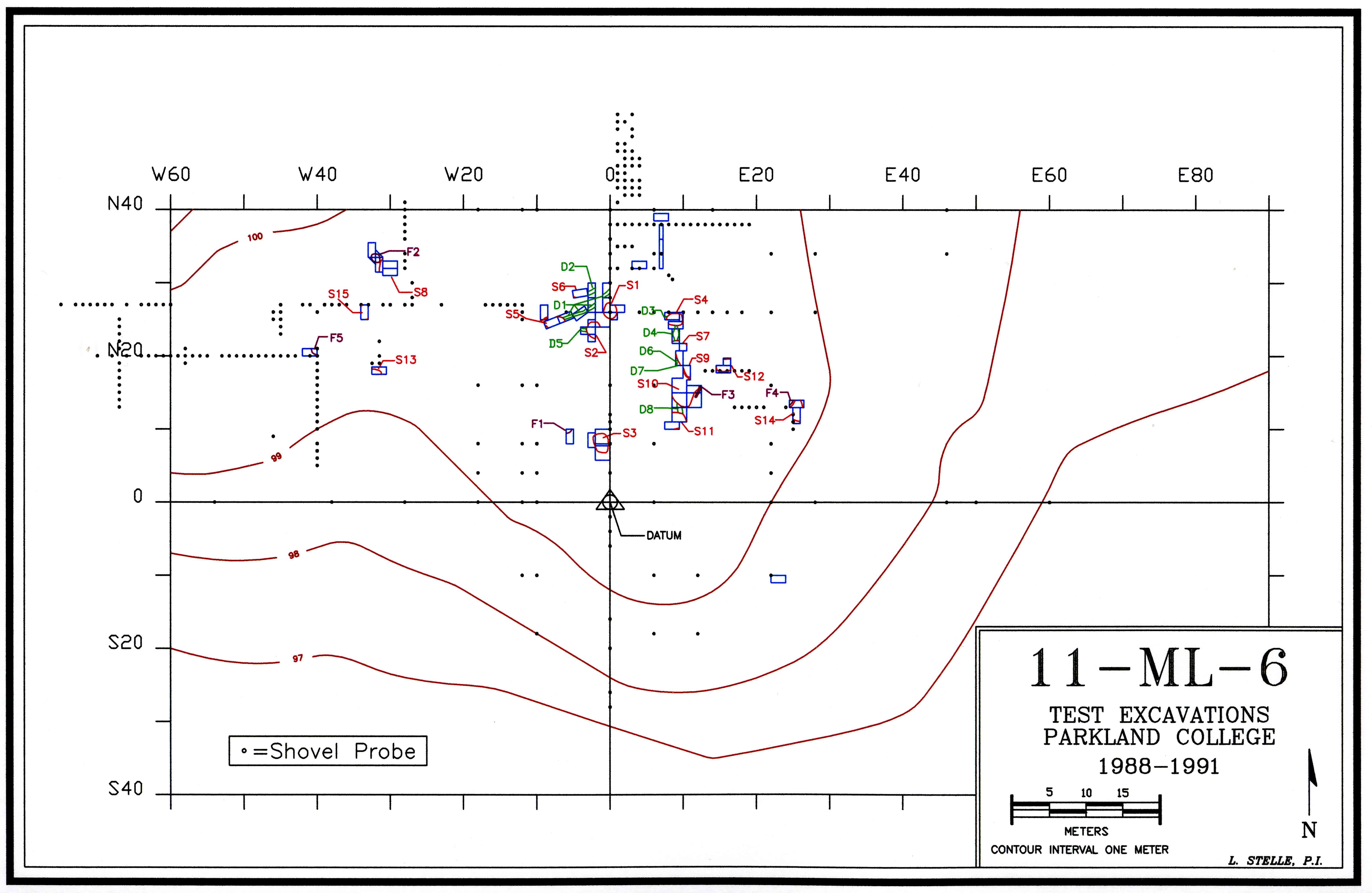
Figure 6-4. Plan View of Excavation and Features.
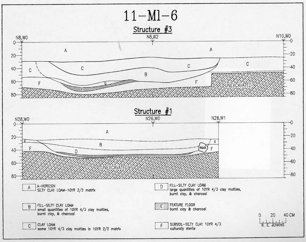
Figure 6-5. Profiles of Structure #1 and Structure #3.
(1) Bone tools
While the analysis of faunal remains has only just begun, three tools of
worked bone and antler have been identified. They were recovered from the
floor of Structure #3 where they were associated with a piece of sheet brass, a
piece of animal hide, and cattail vegetable fiber. All three display regions
of green stain from the water soluble copper compounds. Two were relatively
complete. The larger was 47.5 mm long, 9.8 mm wide, and rectangular in cross
section. It was blunt on both ends where it had been scored and snapped. The
smaller was 46.4 mm long, 8.9 mm thick, and circular in cross section. The
remaining object was incomplete. The fragment was 20.2 mm long, 9.4 mm wide,
and rectangular in cross section. This device had a section of cattail fiber
adhering to its surface. In general, tools of this confirmation are variously
described as either drifts or counters (Wittry 1963:12, 16). Wear patterns on
the recovered objects would not support the first interpretation.
(2) Lithics
Prehistoric Component - The controlled surface collection
yielded a small scatter of lithic material on the east side of a knoll to the
north of the fort area. The recovery included four hafted bifaces and a
unifacially prepared flake. One of the bifaces has a bifurcated base, two are
side notched with excurvate bases, and one is corner notched with an excurvate
base. All four objects are of Burlington chert. They imply the presence of a
Late Archaic-Early Woodland component at the site.
Hafted Bifaces - Ten hafted bifaces, properly considered
arrowheads, were recovered from the test units. Nine are Madison Points and
one is a corner notched variety.
Metrical data on the Madison Points are presented in Figure 6-6. Two of the
points (Figure 6-9.f) came from the plow zone and the others (Figure 6-10.b)
were recovered from the features. Burlington-type chert, often thermally
altered, was the common lithic resource. Specimen N88-54 was fabricated of a
vitreous, fine-grained, strong brown (7.5YR 4/6) chert similar to the French
gunflint (Figure 6-10.b, third from right). Exhausted gunflints and/or
fragments were apparently being recycled as arrow points. Specimen N89-44 was
associated with the articulated dog skeleton in Structure #5. The distal
portion was missing. Three points, including the recycled gunflint, came from
Ditch #4. At the Bell Site, Wittry (1963:28-30) identifies two categories of
Madison Points based upon a width to length ratio: a wide variety and a long
variety. Of the five complete points recovered from Ml-6, three fall within
the range of variation described for the long variety and one within that of
the wide. The fifth point was the recycled gunflint. In width it falls beyond
the range of Wittry's wide variety.
The final point ( <60% complete) came from the plow zone near Structure #5.
It is corner notched, 21.7 mm long, and 6.4 mm thick (Figure 6-10.c). The
parent material is Burlington chert. Thermal alteration is evident. It is
similar to bifaces collected from the Bell Site (Wittry 1963:28). Figure 6-6. Metrical Attributes of Madison Points (all measurements in
millimeters).
Specimen Number
The most distinctive hafted biface to be recovered (Figure 6-10.d) came from
Structure #3 at 43 cm below surface. It was the hafting element of a
Scottsbluff Cluster projectile point (Justice 1987:49). Associated with the
Early Archaic, it seems out of place in this context. The biface was produced
of an attractive strong brown (7.5YR 4/6) chert with black inclusions. The
chert is of variable translucency and vitreous luster.
Gunflints - Ten gunflints were recovered (Figures 6-9.g and 10.a). Two
types are recognized: Native Manufacture (NM) and French Manufacture (FM).
Metrical data are presented in Figure 6-7.
The gunflints of Native manufacture were found both on the surface and in the
features. They are typically of Burlington type cherts. They are produced out
of rather thick flakes. Of the four gunflints of French manufacture, three
came from the floor of Structure #3 and the fourth from the plow zone
associated with Ditch #1. All are the spall type (Hamilton 1980:139). Of the
three objects found in Structure #3 one is a fragment, one is exhausted and one
is complete. Observable colors for the first two are variable, ranging from
10YR 8/4 to 10YR 5/2. The complete gunflint (N88-262) displays some use-wear
and is rendered of black flint with patches of gray. The gunflint recovered
from Ditch #1 (N89-11) is large, little used, and of classic "honey colored"
French flint. While French
Figure 6-7. Metrical Attributes of Gunflints (all measurements are in
millimeters; the bit is treated as the base).
Specimen Number
gunflints are frequently described as "honey colored", the taxon is too
simplistic. All four of the objects fall within the range of color variation
reported from the French components of sites like Ft. Michilimackinac (Stone
1974:255) and Ft. Frederica (Hamilton 1980:147).
Hammerstones - Two hammerstones were recovered, one from Structure #3
and the other from Structure #7. Both were water smoothed, fist sized, and
displayed edge battering.
Catlinite - One object of catlinite was recovered (Figure 6-10.g). It
was an element of a pipe bowl. The walls of the bowl were extremely thin.
Rotational scars were apparent on the interior, as was a dark stain. Pipe
type, either micmac or L-shaped, could not be determined. Wittry describes
similar artifacts from the Bell Site (1963:39).
(3) Ceramics
In the early 1960s an archeologist from an Illinois state agency forwarded two
rim and two body sherds to Dr. Warren Wittry, author of the Bell Site report
(1963). They had reportedly been found on Ml-6 by a local collector. While
he has some reservations, Wittry (1989:personal communication) feels confident
that they are Bell Type I. He and others (Mason 1986:171) consider this
pottery type definitive of the historic Mesquakie.
The present recovery (Figure 6-10.f) included seven small body sherds: two
from the plow zone separating Structures #1 and #2, one from within Structure
#3, and four from on and in Structure #4. The soft paste includes a
distinctive dark grit and sand tempering medium. The exteriors have been
smoothed and are without decoration. The color of the core and interior of the
objects is frequently black, suggesting reduction. Exterior colors vary from
5YR to 10YR, two are black. Wall thickness ranges from 3.9 mm to 7.1 mm.
While these characteristics conform to descriptions of Bell Type I pottery, its
presence is not conclusively demonstrated.
(4) Glass Beads
The glass bead sample includes twelve objects (Figure 6-9.e). They represent
five types. All were recovered in association with Structures #2 and #3.
Type I - Drawn, simple, opaque white (N=7):
Type II - Drawn, simple, peacock blue (N=1):
Type III - Drawn, simple, cobalt blue (N=1):
Length
Width
Thickness
Comments
N88-113
16.2
13.6
3.3
Complete
N88-213
28.5
14.1
3.3
Complete
N89-13
21.5
15.3
3.9
Incomplete
N89-44
14.3
8.9
3.7
Incomplete
N89-45
15.4
11.9
2.8
Incomplete
N89-54
15.6
16.8
3.3
Complete
N89-57
23.4
14.3
2.1
Complete
N89-68
19.1
13.2
3.4
Incomplete
N89-80
22.7
14.1
3.3
Complete
Length
Width
Thickness
Type
N88-SC
19.0
20.3
5.2
NM
N88-SC
20.7
27.0
18.6
NM
N88-262
15.0
14.8
5.5
FM
(frag)
N88-262
20.6
22.3
6.9
FM
N89-11
25.7
30.0
18.6
FM
N89-15
9.7
13.8
6.4
FM
(frag)
N89-28
24.3
27.8
4.4
NM
(frag)
N89-40
19.1
19.2
9.5
NM
N89-74
25.7
25.7
9.1
NM
N89-81
29.3
28.7
5.7
NM
Type IV - Drawn, simple, opaque white (N=1):
One large (7.3 mm), tubular bead of a dull white glass was identified. It
corresponds to Good's Type 103 at the Guebert Site (Good 1972:118). The
temporal assignment would be 1719 to 1833.
Type V - Wire-wound, simple, opaque white (N=2):
In summarizing the temporal data on the glass beads the maximum range is 1600 to 1833 and the minimum range is 1719 to 1731. While Wittry recovered no seed beads from the Bell Site, he does report two of the five types identified here.
(5) Brass
Twenty-one brass objects were recovered. Three are small, triangular pieces of sheet brass; six are tinkling cones; one is a button; and the last eleven are irregular pieces of sheet brass.
The triangular pieces of sheet brass (Figure 6-9.c) are small (bases range from 11 mm to 17.9 mm). One has a perforation near the center. They are interpreted as arrowheads. Two came from near the floor of Structure #3. Discussed under the sheet brass, the association of these objects with a piece of sheet brass suggests the production of the arrowheads in this feature. Based on the density of small fragments of sheet brass, production may also have been occurring in Structure #6, where the perforated form was recovered.
Four complete tinkling cones were recovered, along with fragments of two others. Lengths ranged from 17.7 mm to 31.2 mm (Figure 6-9.a). The tinkling cones were recovered from both the plow zone and feature fill (Structures #2, #3, and #6). A fragmented specimen came from the floor of Structure #2 where it was associated with a concentration of seed beads. As indicated in the previous paragraph, Structures #3 and #6 gave indication of sheet metal processing.
The brass button (Figure 6-9.b) has a simple dome shape with a stamped flat edge. Brazed to the back is a solid, wedge shaped shank with a hole drilled in it for attachment. The button is 24.8 mm in diameter. Brain (1979:189) identifies ten sites from which this button type has been recovered. Maxwell (1964:27) also reports it from the French horizon at Fort Michilimackinac. Following Quimby (1966:78-79), Brain assigns this type to the Middle Historic Period, observing that it may have been associated with the Louisiana Independent Companies. The button was recovered from the plow zone between Structures #1 and #2.
Eleven pieces of sheet brass were identified (Figures 6-9.d and 11.f). Ten of the objects were small and of indeterminate function. The most conspicuous piece (Figure 6-11.f) was in the general form of a parallelogram measuring 89.5 mm along its maximum dimension. It was recovered from the floor of Structure #3. A triangular notch 22 mm deep and 17.9 mm wide is present along one margin. The notch appears to have been cut by shearing, however, there is no indication of the tool used. The close physical proximity of this material to the brass arrowheads implies that the points were being produced in this structure. A large number of unidentifiable sheet brass objects were collected from Structure #6. The association of brass arrowheads and tinkling cones in this unit suggests that production was occuring here also.
(6) Copper
A single item of copper was identified. It was approximately half of a "C" bracelet (Figure 6-11.e). There was no decoration. It was rendered of a copper-rich rod or heavy wire 4.3 mm in diameter. The bracelet was recovered from the floor of Structure #7. Similair artifacts are reported from the Bell Site (Wittry 1963:17) and the Guebert Site (Good 1972:130).
(7) Iron
While many objects of iron were recovered from the surface and plow zone of the fort area, only two appear to date from the eighteenth century. Both are knife blades, one a clasp type (Figure 6-11.c) and the other a case type (Figure 6-11.d). The only other knife blade recovered was a clasp type (Figure 6-11.b) that came from 73 cm below surface in Structure #5. The blades of the clasp knives have a single hinge hole and a flange at the butt end. No maker marks are apparent. The surface collected blade is too deteriorated to permitt the direct determination of blade type. However, the configuration of the hafting element is similar to one illustrated from Ft. Michilimackinac (Stone 1974:262,C). The illustration is of "standard" blade shapes. Stone (1974:265) assigns dates of 1680 to 1760 to this variety. The knife blade from Structure #5 is heavily oxidized but complete. The blade back is angular. Both portions of the back margin are straight. This knife is also an example of Stone's "standard" blade shape category.
The blade remnant from the case knife is distinguished by a tang that is offset and tapering. Good (1972:166) interpretes a similar object from the Guebert Site as a butcher knife.
A large tool of bar iron (Figure 6-11.a) was recovered from the floor of Structure #7. It has a length of 356 mm and a mass of 557.3 g. Both ends have been flattened into a curved or gouge-shaped bit. The function of the tool remains undetermined although it could conceivably have been used for hide processing. Burnham (1897) describes two similar tools from his 1897 visit to the site. They were both rendered of gun barrels.
Two iron objects were recovered from below the plow zone in Structure #3 and in #6. Morphologies and functions could not be determined.
(8) Lead
Several elements of a lead smelting production trajectory were identified. These include raw lead sulfide in the form of galena cubes, lead clinkers, lead drip globules, bar lead, and lead musket balls. Walthall argues that the Mesquakie were extracting galena from southern Wisconsin from a very early point in time (1981:25). The Bell site also displayed evidence of such a trajectory (Wittry 1963:38). Six items from the recovery have been forwarded to Dr. Ronald Farraquhar at the University of Toronto. He is performing a trace element analysis. This work has the potential of yielding information relevant to the geography of extraction loci and the production trajectory.
Two small cubes of galena (Figure 6-9.h) weighing 8.9 g and 3.7 g were recovered. One came from the plow zone between Structure #1 and #2 and the other from the floor of Structure #3.
None of the lead clinkers (Figure 6-9.i) were found in primary context. Most were from the plow zone but one was from Ditch #1 at 40 cm to 50 cm below surface.
Three small lead drip globules (Figure 6-11.g) were recovered. Two from Structure #3 and one from the plow zone above Structure #4.
The length of bar lead (Figure 6-9.j) weighs 42.1 g and is 48.2 mm long. The cross section is triangular. It came from near the floor of Structure #2.
A lead disk with a single perforation through the center (Figure 6-11.h, left) was recovered from 58 cm below surface in Structure #7. It was 19.9 mm in diameter and 5.5 mm thick. The diameter of the perforation was 2.8 mm. A second lead disk (Figure 6-11.h, right) was recovered from 46 cm below surface in Structure #6. It was 19.9 mm in diameter and 4.3 mm thick. The single orifice was 2.3 mm in diameter and collared. Both may have been hammered from musket balls. Objects like this have been reported from Guebert (Good 1972:154), Ft. Michilimackinac (Stone 1974:153), and the Bell Site (Wittry 1963:38). A similar object was also recovered from the nearby Warren Bane Site (Smith 1978:117). Stone and Good refer to them as "whizzers" and interpret the disks as noise making devices. Smith views his object as a lead bead and Wittry identifies his as a fishing sinker. They date from throughout the eighteenth century.
Thirty-six musket balls were recovered (Figure 6-9.k). Eighteen were too deformed to be able to determine caliber. A frequency distribution of the remaining balls is included in Figure 6-8.
This distribution compares favorably with what Hamilton (in Brain 1979:209) reports for the Tunica and with what he (1980:134) describes for a variety of other eighteenth century sites. The 68 and 69 caliber balls from Michilimackinac are likely associated with a later English Infantry component (Hamilton 1980:129). He concludes that 54 caliber and 56 caliber were the most common French tradegun bores (Hamilton 1980:128).
The musket balls displayed a number of variations including remnant sprues, off center molds, mold scars, and knife cuts. Two also displayed the curious effect of "chewing" (Good 1972:145).
Summary
The artifactual assemblage reveals several things regarding the cultural and temporal contexts of the people who occupied Ml-6. The predominance of war materials, their production on the site, as well as the volume of spent bullets, clearly indicate a state of battle and perhaps siege involving a Native American society. The temporal context focuses upon the first half of the eighteenth century, with the analysis of the glass beads suggesting a range of 1719 to 1731. The historical issue of whether the combatants were the French and the Mesquakie is more difficult. The most direct indication of a French presence is the military button. Alone it is not enough to conclude that the French were present. The aboriginal culture remains uncomfortably diffuse. At the level of individual artifacts, and disallowing the interpretation of Bell Type I ceramic, one can only demonstrate a native society of the Middle Historic Period. However, when taken as a whole, the data seem to indicate the Mesquakie. The low but measurable frequency of stone tools, the predominance of French trade goods, the types of glass beads, the characteristics of the projectile points, the lead ball production trajectory, the style of the knives, and the likelihood of Bell Type I ceramic all argue in favor of this conclusion. While the line of evidence is thin, the conclusion is reasonable.
Figure 6-8. The Distribution of Musket Balls Recovered from the Ml-6 Compared to Selected Mid-western Sites (adapted from Hamilton 1980:134).
Caliber
|
Ml-6
|
Tunica
|
Haynes
Bluff
|
Michili-
mackinac
|
23Sa3
|
| 45
|
-
|
2
|
-
|
-
|
-
|
| 46
|
-
|
-
|
-
|
-
|
-
|
| 47
|
-
|
-
|
-
|
-
|
-
|
| 48
|
-
|
-
|
-
|
2
|
-
|
| 49
|
-
|
-
|
-
|
-
|
-
|
| 50
|
-
|
-
|
-
|
3
|
-
|
| 51
|
-
|
1
|
-
|
6
|
-
|
| 52
|
1
|
3
|
-
|
12
|
1
|
| 53
|
4
|
3
|
-
|
11
|
1
|
| 54
|
3
|
24
|
2
|
22
|
-
|
| 55
|
-
|
23
|
4
|
47
|
3
|
| 56
|
1
|
19
|
1
|
74
|
3
|
| 57
|
2
|
14
|
2
|
92
|
3
|
| 58
|
1
|
7
|
9
|
73
|
-
|
| 59
|
1
|
2
|
4
|
51
|
-
|
| 60
|
1
|
2
|
-
|
17
|
-
|
| 61
|
-
|
1
|
1
|
16
|
1
|
| 62
|
-
|
-
|
-
|
10
|
-
|
| 63
|
2
|
1
|
-
|
2
|
-
|
| 64
|
1
|
1
|
-
|
1
|
1
|
| 65
|
-
|
-
|
-
|
2
|
1
|
| 66
|
1
|
-
|
-
|
2
|
-
|
| 67
|
-
|
-
|
-
|
1
|
-
|
| 68
|
-
|
-
|
-
|
14
|
-
|
| 69
|
-
|
1
|
-
|
25
|
-
|
| Total
|
18
|
104
|
23
|
448
|
13
|
Faunal Analysis. Because of the high acidity of the soil and the prospect that many of the osteological remains were boiled, faunal preservation has not been good. Nonetheless, some quantity of faunal material has been recovered. Dr. Terrance Martin of the Illinois State Museum is presently conducting the analysis with the findings to be released shortly. This site has the potential to shed important light on the nature of subsistence under battle and siege conditions. It may additionally provide insight into religious and economic practices. However, only a few preliminary observations can be offered at this time.
Bison bison is conspicuous in the recovery. The massivity of the skeletal elements, of course, may have contributed to a situation of differential preservation. Impressionistically, the assemblage centers on cervical vertebra. The presence of a limited array of meat units suggests that the bison were processed somewhere off-site. That bison are present at all is somewhat surprising and leaves open questions concerning the nature of the procurement process. Based on the eyewitness narratives, two speculations are possible. The first possibility is that the bison were secured sometime prior to the arrival of the French military groups and the initiation of the siege. The Mesquakie may have been on the prairie for more than a month before the first of these groups arrived. De Villiers' account indicates that he had examined two small camps that they had occupied earlier in the summer. His emphasis on their small size creates the possibility that they were nucleated hunting camps. Furthermore, the first French group to arrive was from Ft. de Chartres. Their initial contact was with a hunting party of 40 Mesquakie. Clearly, the Mesquakie were procuring meat in advance of the siege and bison could have been included.
The second speculation is that the Mesquakie were provided bison by the Sauk or other groups subsequent to the beginning of the siege. The reports indicate that the Sauk, at least, were smuggling food to the Mesquakie and that it posed a major problem for the French alliance.
The remains of Canis familiaris are also very conspicuous in the recovery. At least five of the seven structures displayed associated faunal elements. The burial of the animal in Structure #5 is very intriguing. If Ml-6 is a Mesquakie site the presence of canids is to be expected. The social, religious, and medicinal involvement of the Mesquakie with their dogs is well documented in the ethnographic and archaeological literature. Dog ceremonialism is described from the Bell site (Wittry 1963:6-7) as is the eating of dog. Given the prospect of a twenty-three day siege, the stress it would have placed on the society, and the need for care of the sick and wounded, it seems likely that all three of these cultural expressions were invoked here. The completion of the analysis should clarify this important question.
A lower canine of Ursus americanus was recovered at 53 cm below surface in Structure # 3. Its singular character and close proximity to a large (length 58.1 mm, diameter at large orifice 30.7 mm) horn coral fossil (Figure 6-10.e) suggests the possibility of the two objects being religious relics. Ethnographic studies provide insights into the relationship between the Mesquakie and Ursus. The Bear Clan was of great importance to the social organization of the Mesquakie. As was the case with many historic societies of the region, the Bear Clan was a structural unit of major prestige and power. Totemic expressions could be anticipated. Secondly, the processing of the animal subsequent to procurement evidenced many religious and ritualized elements. Wittry (1963:6) was able to demonstrate some aspects of bear ceremonialism at the Bell site. Lastly, the distribution of the meat was important to a system of exchange based on reciprocity. The apparently isolated nature of this find, however, suggests a symbolic rather than dietary function.
Lastly, the preliminary analysis revealed no human remains. A fact significant in its own right, one would have expected some causalities given all the evidence of combat. The disposition of the dead remains unknown.
Invigorated with fresh historical information regarding the location and design features of the 1730 Mesquakie fort, an archaeological reconnaissance of 11-Ml-6 was undertaken. A conservative interpretation of the findings would be that the site has at least seven semi-subterranean structures with earth covered roofs. Some of these structures were connected by ditches. The evidence of armed conflict is everywhere. The artifactual recovery reveals a Middle Historic Period native society. In this view, 11-Ml-6 is a battle site dating from the right time frame. A more liberal reading of the data would allow for the presence of the Mesquakie. While the data are not definitive, the conclusion seems reasonable. The evidence for the presence of the French is inconclusive. They cannot be demonstrated. The lack of artifactual data bearing on this issue may in part be a function of the areas that have been examined. The present research has centered on the fort locality and the French would have encamped some distance away (the Reaume Narrative suggests that the French camps were more than a half mile from the fort). As the research proceeds a more complete examination of these areas will be accomplished.
In an earlier section of the paper it was observed that in order for Ml-6 to be interpreted as the 1730 Mesquakie fort it must demonstrate the presence of the Mesquakie, the French, the fort, and a 1730 horizon. Three of the four requirements have now been achieved.
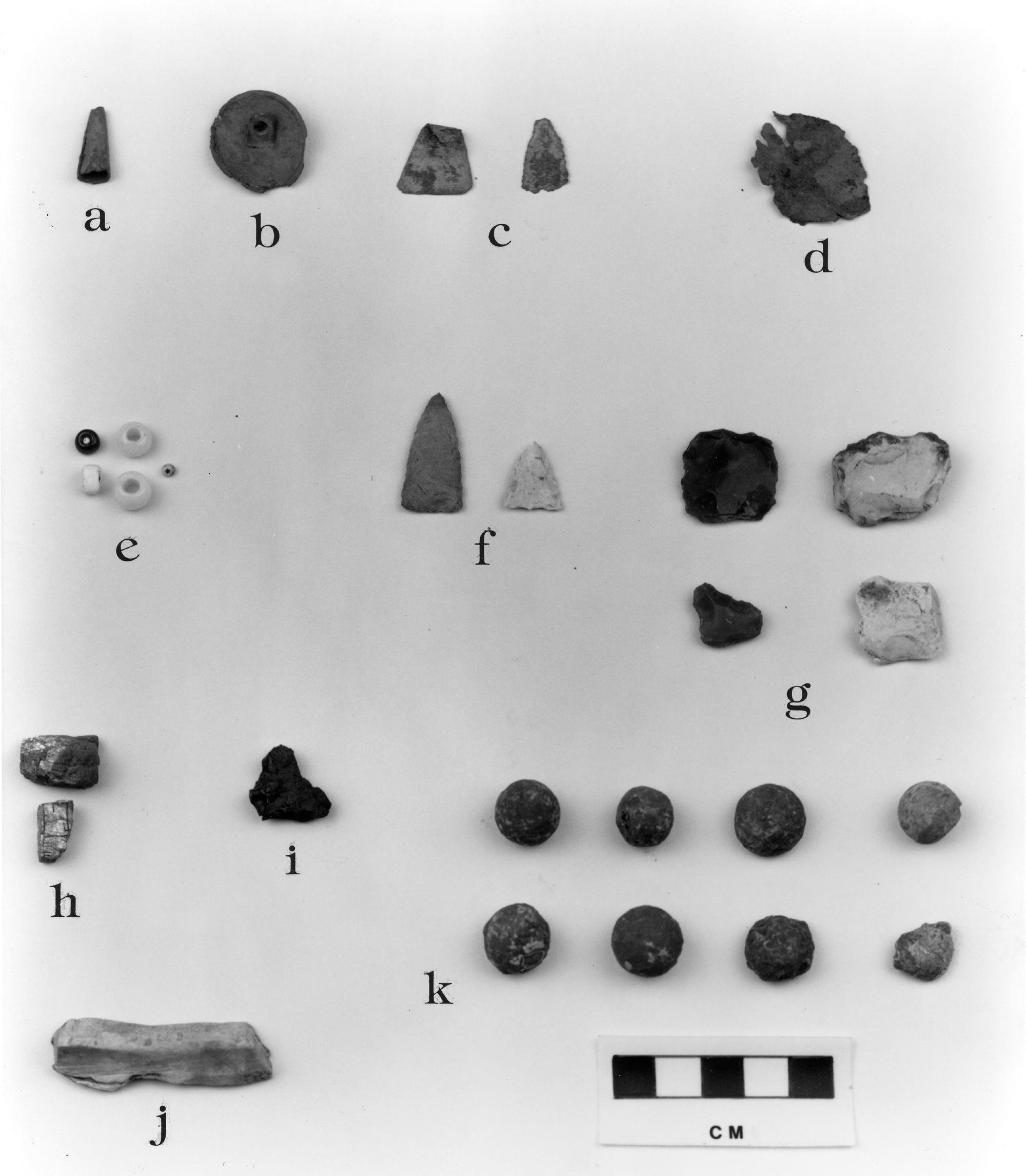
Figure 6-9. Artifacts Recovered from 11-Ml-6 During 1988.
a. Brass tinkling cone, typical
b. French military button, brass, reverse side
c. Brass arrowheads
d. Indeterminate sheet brass
e. Glass beads
f. Madison Points
g. Gunflints
h. Galena cubes
i. Lead clinker, typical
j. Bar lead
k. Musket balls, typical
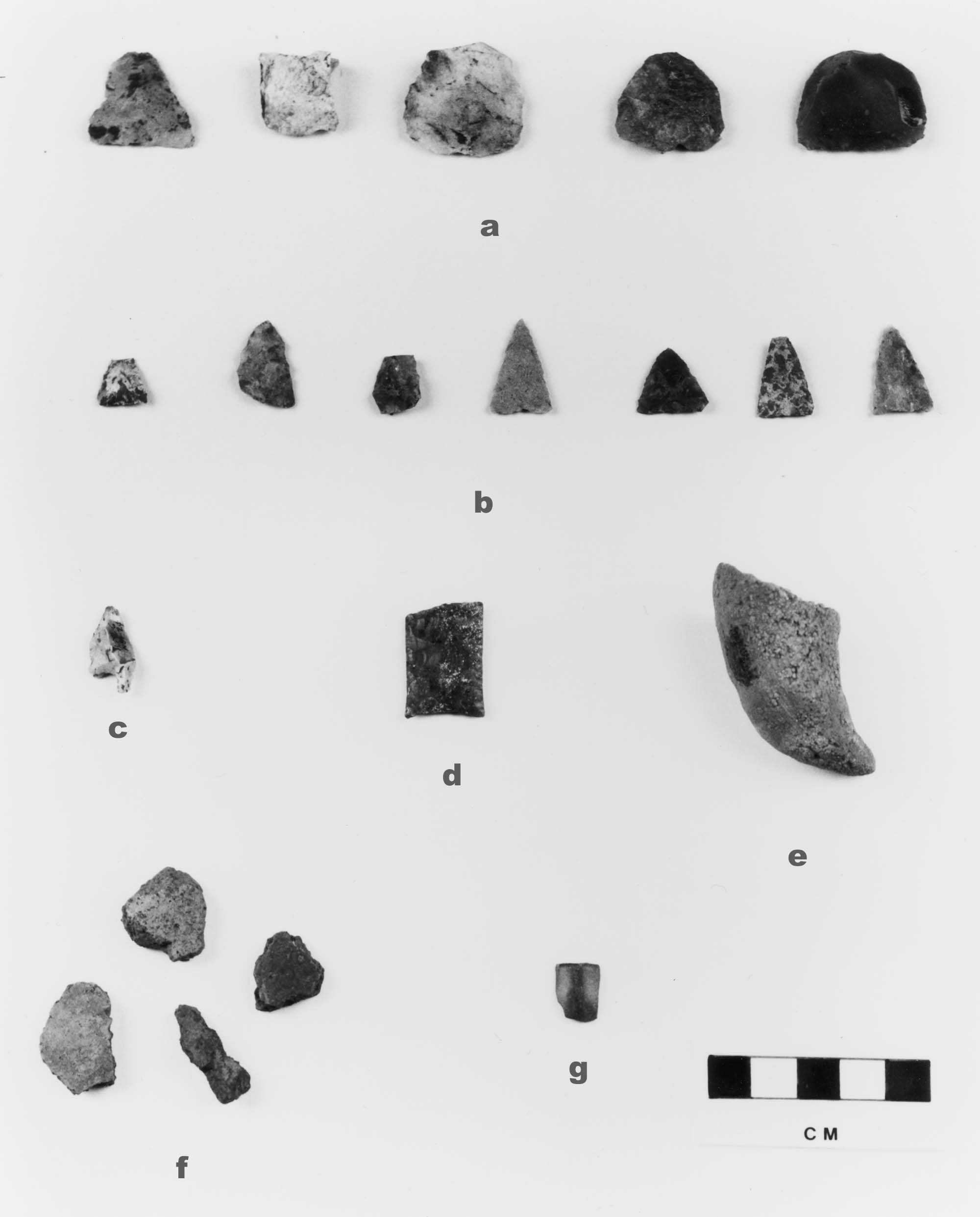
Figure 6-10. Artifacts Recovered from 11-Ml-6 During 1989.
a. Gunflints
b. Madison Points
c. Corner notched biface
d. Basal element, Scott's Bluff biface
e. Fossil, horn coral
f. Sherds of mafic grit tempered ceramic, typical
g. Catlinite pipe bowl fragment
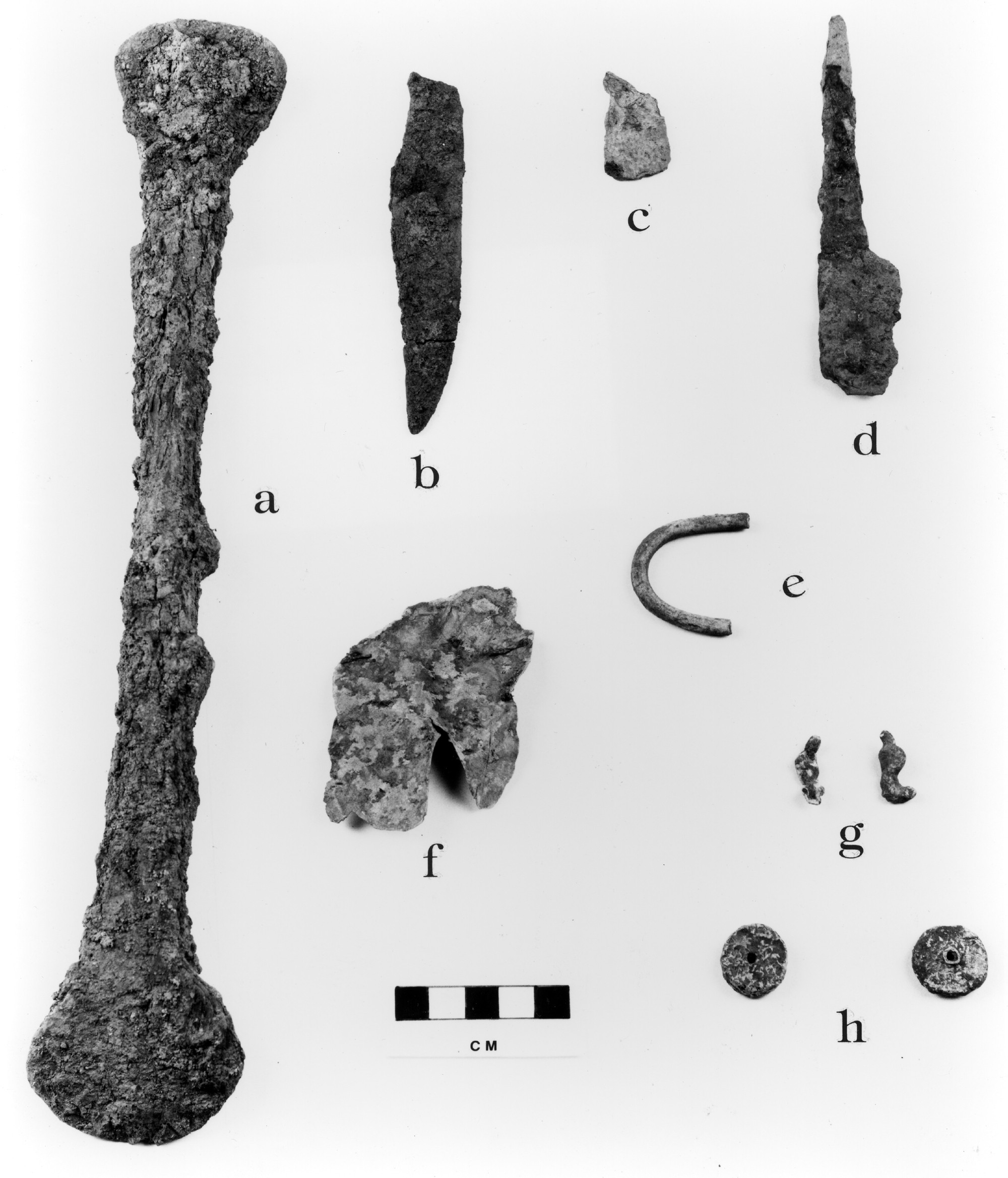
Figure 6-11. Artifacts Recovered from 11-Ml-6 During 1989.
a. Iron tool
b. Clasp knife, standard variety
c. Clasp knife, standard variety
d. Case knife with off set, tapering tang
e. Copper "C" bracelet fragment
f. Sheet brass
g. Lead globules
h. Lead disks
Acknowledgments. The author would like to thank the many students who have contributed to this study; field supervisor, Mary K. Porter; Enrique Calle, manager of the Parkland College AutoCad Laboratory; Ray Jenkins for the AutoCad illustrations; and Chuck Mercer for the photographic illustrations.
Collections of the State Historical Society of Wisconsin
1908 Conflicting Accounts Found In Early Illinois History. Transactions of
the Illinois State Historical Society 13. Springfield.
The document interpreted as the Reaume Narrative was located in the Inventaire Analytique, Colonies, B 75-189, F3 24-25-50-51-78, D2c 2-3, Canada 1680-1785, COL/06, Colonies F3, Vol. 24, Description et Historique Louisiane 1680-1755, Moreau St. Mery, Folio 196.
Dr. Carl Ekberg, Professor of History, Illinois State University, graciously provided the following translation.
Letter from Monsieur d'Auteuil de Monceaux, dated at Quebec 17 November 1730, concerning the destruction of the Foxes
For several years we had been working without success to destroy this audacious and rebellious tribe [nation]. Monsieur de Beauharnois, with wise and prudent orders, had ordered Sieur Jean-Baptiste Reaume, interpreter for the Indians along the St. Joseph River, under the command of Monsieur le Chevalier de Villiers, lieutenant in His Majesty's troops, to work either for peace or for war with the Foxes. He [i.e. Reaume] spent last winter trying to stir up trouble between them and their allies, the Sacs, the Kickapoos, and the Mascoutens. He had spies everywhere, and finally in May he learned from the Kickapoos and Mascoutens that the Foxes were intending to pass by the Rock in order to go with their families to the Iroquois, which was confirmed by an Illinois Indian. Thereupon, Monsieur de Chevalier de Villiers sent this news to Detroit, to Monsieur de Schaillons [Deschaillons] with the Miamis, to Monsieur de Noyelles with the Ouiatenons, and to Sieur Simon Reaume. Within 24 hours, Monsieur Deschaillons had a party of 350 men, composed of 35 French, some Hurons, some Ouiatenons, and some Potawatomis, commanded by two of his sons. Monsieur de Noyelle was at the head of some Frenchmen and 140 Miamis. Sieur Simon Reaume commanded 400 Ouiatenons and some Frenchmen. The army from Detroit was integrated with that of the Miamis. They all joined together and started out for the Rock. They learned that Monsieur de Villiers had fallen back with 350 men, not knowing how to find the Foxes nor even knowing the route of their march, releasing our warriors after having marched more than 100 leagues. This retreat caused the Foxes to send an envoy to the Illinois to ask for the right to pass through. In the council cabin an angry young man struck out at the envoy with a tomahawk and with a knife. This aggressor was put outside and the council continued. After this envoy retired to his village, five leagues from the Rock, and 5 days later, in order to get revenge he killed or had killed some Illinois. This blocked their passage to the Iroquois. On the road Monsieur de Villiers ran into a Potawatomi chief named Oukia, a sworn enemy of the Foxes, who had not been invited by his tribe to this war; full of resentment and courage he had a small party of 18 men. Passing close to Monsieur de Villiers, who asked to know the reason for their march, he responded that he was going to the Illinois and while on the way he wanted to smash the heads of the Foxes. Sieur Jean-Baptiste Reaume [with Villiers' party] was clever, telling him [Oukia] that it was necessary to get the Mascoutens and Kickapoos involved by reproaching them for forgetting their dead, that he wished to be the revenger of the blood that they had lost, and that he wanted to retrieve the bones of those of them that the Foxes had killed.
These [former] allies of the Foxes, seeing themselves shamed by a stranger, sang the warsong and left with him [Oukia] with 150 men, along with 40 Potawatomis who had joined them. They went to seek out the Foxes 50 leagues southeast of the Rock, where they found them. They [the Foxes] made a retreat to a woods, for that region is only prairie as far as the eye can see. They [the allies] approached and gave battle from noon until evening.
Both sides lost 7 or 8 men and the Foxes had 30 wounded. But our poor General Oukia lost his life after having many times repulsed his enemy. Finally the two armies, very tired, separated. The Foxes fortified themselves in their woods and the allies in the prairie a half a league from each other. The Fox fort was of stakes a foot apart, crossed at the top, all joined together and filled in with earth between them as high up as the crossing. On the outside a ditch ran around on three sides with branches planted to hide it, with pathways of communication for the fort in the ditches and others that ran to the river. Their cabins were complete with joists covered with decking, commonly called straw mats. On top of this there were covered ways such that one could see only an earthwork [terrasse] that would cast a shadow in the fort.
The two enemies having many wounded and neither one daring to attack again proposed a truce. This was accepted and for reciprocal proof of their sincerity they exchanged presents and meat. But the allies profited from their confidence to send runners to ask for help to the St. Joseph River, where Monsieur de Villiers and Reaume had just arrived; also to the Miamis, the Ouiatenons, and the Illinois.
Immediately Baptiste Reaume, with the consent of Monsieur de Villiers, had the warsong performed in the villages of the Sacs. the Potawatomis, and the Miamis, who accepted the tomahawk to the number of 300 savage men. They left 4 days later, Monsieur de Villiers accompanied by two Frenchmen and placing his confidence in the conduct of Sieur Reaume, for nothing was more important than to have a man of experience and influence, as he [Reaume] exercises on the temper of his tribe, in order to persuade them to wage war on their relatives.
Monsieur de Noyelle, commandant with the Miamis, didn't lose a moment in assembling the Miamis, who marched with him to the number of 130, plus 4 Frenchmen.
Sieur Simon Reaume, 66 years of age, who for 4 years had led and maintained under orders from Beauharnois the Ouiatenons, also allies of the Foxes, chanted for war against these rebels, pressed his tribe so hard with his expressions that they dared not refuse his request. He stirred up with his influence and authority blood against blood, and relatives and friends that they were, he turned them into enemies. He marched at the head of 400 Ouiatenons and 28 frenchmen. These gentlemen each left from their own post, 100 leagues apart from one another. They strode off, animated by glory and zeal for the service and by the desire to vanquish; they lost not a moment in seeking out the shortest pathways to arrive for combat.
Monsieur Villiers and Simon Reaume arrived the first and Monsieur de Noyelle some time latter. Together they encircled the fort of the rebels. Monsieur de St. Ange leading 300 Illinois and 90 Frenchmen joined up with them. The Kickapoos, Mascoutens, and Sacs, who had always respected the Foxes, did the same thing, and all these groups together constituted a small army that besieged the enemy. As there were some Frenchmen there, prudence did not require forcing the issue with an assault since their [the Foxes'] defeat was certain and since hunger would make them perish. The besiegers opened the attack trench with axes and knives; they planted cavaliers under cover of gunfire. This siege lasted 18 days, during which time the besieged threw over their palisade more than 300 children in order to touch the hearts of the besiegers their allies, while calling out to them that since they hungered after their own flesh that all they had to do was eat of it and quench their thirst with the blood of their close relatives, although they were innocent of the fault that their fathers had committed. They received with open arms these children, but Sieurs Reaume, whose prudence was based on 40 years of experience, vigorously opposed doing this on grounds that it might be a prelude to a general pardon. They immediately ran throughout the camp reproaching them that they were not warriors since they dared to take some men, and that the orders of their father the governor was not to punish innocents but rather those who had broken the peace treaty by spreading the blood of all those who made up this army. As the commandants and Sieur Reaume perceived that the besieged and the besiegers were engaged in frequent conversations, they judged that it was necessary to keep up a continuous fire in order to destroy any plans that might have been carried out.
The Foxes, seeing a hopeless situation and dying absolutely of hunger, proposed to Sieur Baptiste Reaume that they would surrender themselves to all the tribes in return for their lives. But he did not agree, nor did his brother, foreseeing that they [Foxes] were capable of compromising those with whom they would live. It was decided by the commandants that no quarter would be given.
The night of the 18-19th [sic] was so dark with much thunder and rain that it was impossible to see. The besieged made a large fire inside of their fort. The Sieurs Reaume warned the commandants that they were going to flee but that it was not necessary to oppose this because in the melee the allies would fire upon the French as well as upon the Illinois, the later not being liked by the attacking tribes. Nor was it to be feared that the enemy could go very far; within 9 days the besiegers would be forced to do their duty.
At midnight the besieged left their fort. But the Sieurs Reaume made use of clever orders in saying to the Sacs, who were the most accused of being in league with the Foxes, that it was necessary for them to prove themselves to their father the governor and the entire army by taking prisoners that night. They did that at exactly the same time that the Sieurs Reaume told the tribes that only the Sacs knew how to take slaves. This motivated them to the extent that they took 300 during the night.
At day break they were pursued with so much vigor that those who were furthest away were stopped and killed 8 leagues from the fort. It was said that there were 500 killed, namely: 200 men and 300 women and children. Three hundred women and children were taken prisoner. The warriors followed customary practice. They exchanged the slaves as presents, included among which were 40 men who were burned. Those who lived reported to Sieur Baptiste Reaume that there were no more to take. This would give peace to the colony and would increase its commerce through possession of the lands that they [the Foxes] occupied and of those where our Indians dared not hunt for fear of these fearsome enemies.
Communications will soon be open for the Mississippi as well as for the Sioux settlements. The region around the [Green] Bay will be peaceful and an agreeable settlement will be made there. The settlers at Detroit and Lake Erie will cultivate their gardens in complete security. Finally, there is a general peace, which well merits that the authors [apparently the Reaume brothers] of it should be rewarded.