POST-GLACIAL ENVIRONMENTS IN EAST-CENTRAL ILLINOIS:
An Environmental Summary of the Lake of the Woods Park, Champaign County, Illinois


Lenville J. Stelle
Parkland College
Champaign, Illinois


© 1993 by the Center For Social Research, Parkland College


ABSTRACT


The Lake of the Woods Park, Champaign County, Illinois, lies at the intersection of the Champaign Moraine and the Sangamon River. The moraine is a late Woodfordian deposit that dates from at least 16,000 years ago. The river is weakly entrenched and has been relatively stable during the ensuing millennia. With the exception of the floodplain alluvia, the soils of the park are formed in glacial outwash covered by several feet of loess. The modern climate of the study area is temperate continental. The sequence of climatic changes that has occurred since deglaciation is explored along several evidentiary lines.

Using data from the 1822 Government Land Office survey of Mahomet Township, as well as more recent studies, the vegetative context of the park is reconstructed. Eight natural communities are identified and described. Drawing upon zoological, historical, and archaeological literature, a systematic overview of the faunal assemblage is provided. Seven taxonomic classes are discussed including mammals, birds, amphibians and reptiles, fish, mollusks, and insects.

ii


ACKNOWLEDGEMENTS


I would like to extend my heartfelt gratitude to the many individuals without whose help, guidance, and support this study would not have been possible. Specifically, I would like to thank Cheryl Kennedy, Director of the Early American Museum, for her unflagging encouragement; Mary K. Porter for her able-bodied assistance; Margaret Kuehn for her preparation of the manuscript; Dr. Bruce B. Suttle, Earl Creutzburg, and Bruce Morgan for their critiques of early drafts of the manuscript; Dr. R. Barry Lewis for his many years of encouragement and support; and my family for the time I stole from them. I would also like to thank the Champaign County Forest Preserve District and Parkland College for their ongoing material support of the project.

Of course, all errors are mine.
					L. J. S. 
					15 Feb 87 


iii


TABLE OF CONTENTS
(Click on Chapter titles to go to chapter)


Chapter Title Page
ABSTRACT ii
ACKNOWLEDGEMENTS iii
LIST OF FIGURES v
LIST OF TABLES vii
INTRODUCTION 1
GEOMORPHOLOGY AND HYDROLOGY 2
SOILS 1
CLIMATE 7
VEGETATION 13
Government Land Office (GLO) Survey 13
Floristic Reconstruction 16
FAUNA 26
Mammals 26
Birds 31
Amphibians and Reptiles 34
Fishes 38
Mollusks 42
Other Invertebrates 44
Conclusions 45
CONCLUSIONS 46
APPENDIX 48
REFERENCES CITED 51


iv


LIST OF FIGURES
(Click on Figure number to go to graphic)


Figure
Page
Figure 1. Moraines of the Upper Sangamon Basin.
4
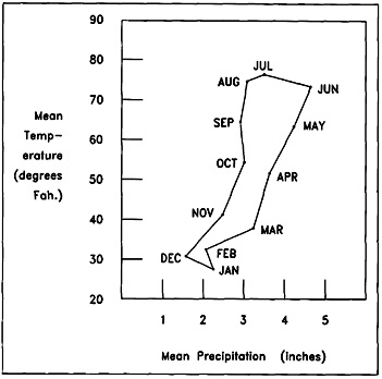
Figure 2. Climatograph Displaying Monthly Mean Temperature and Precipitation for Urbana.
9
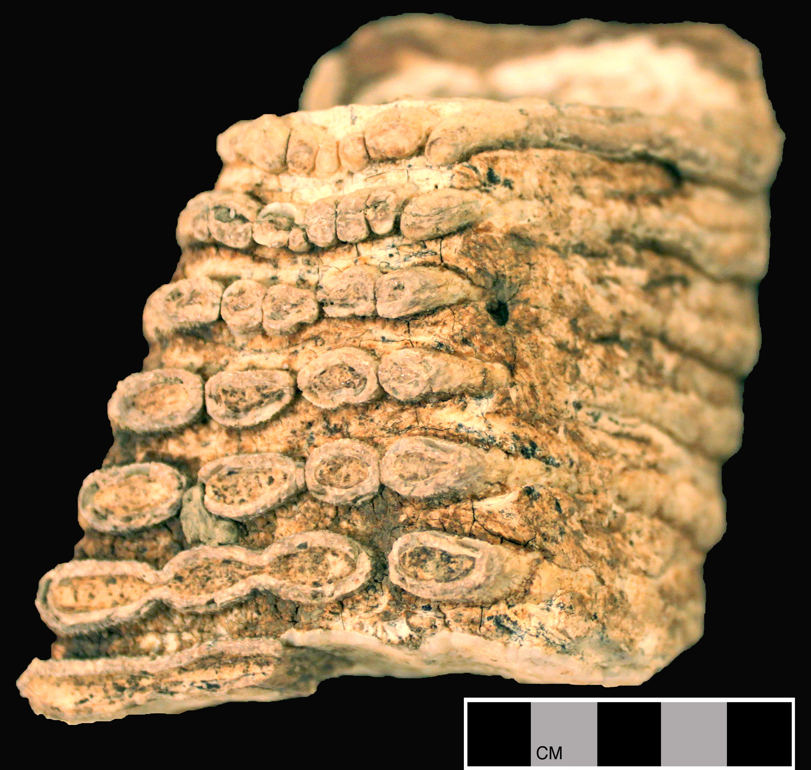
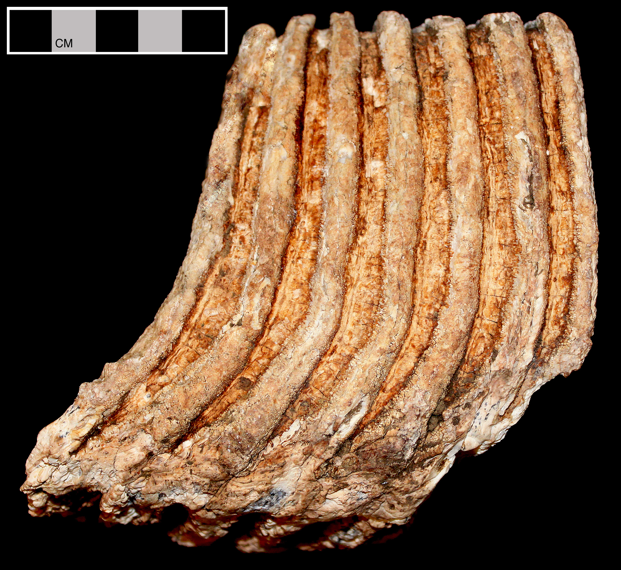
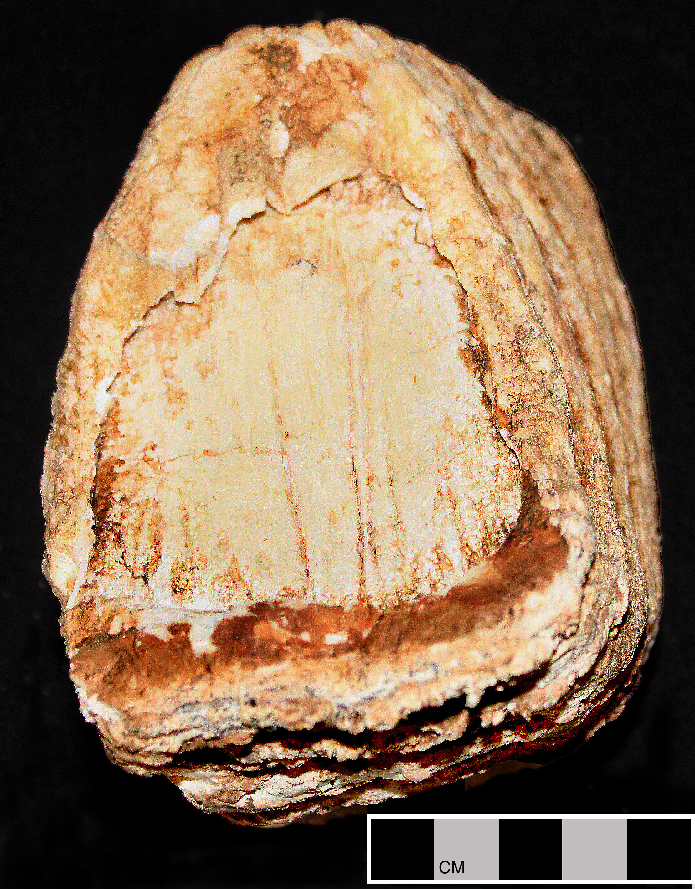
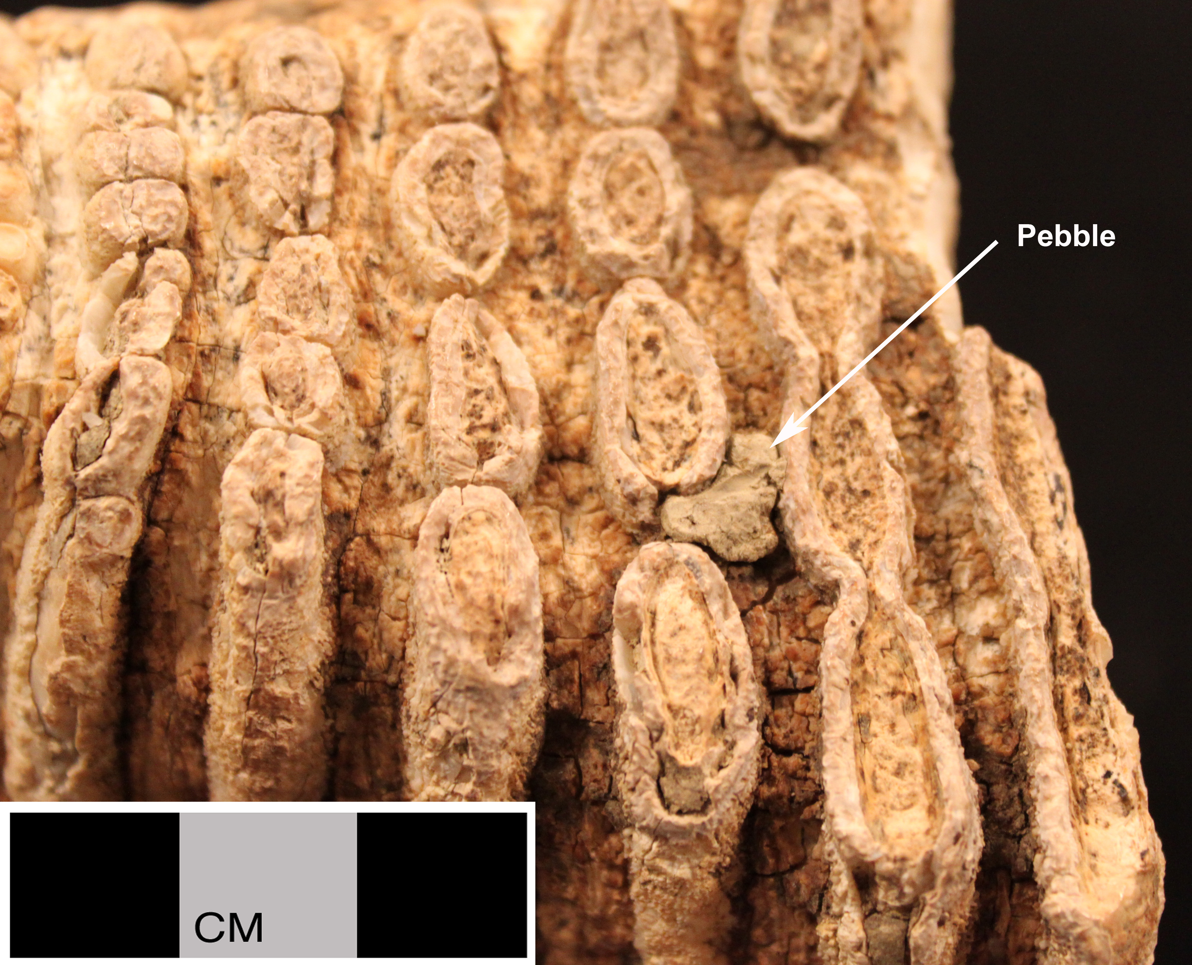
Figure 3. The illustrated faunal element is a fragment of the Left Inferior M3 9-15(?)/24 of Woolly Mammoth (Mammuthus primigenius) recovered from a residential subdivision development located less than a mile west of Parkland College, Champaign County.
15
Figure 4. The Original Land Survey Map of Mahomet Township, Champaign County.
17


v


LIST OF TABLES
(Click on Table number to go to graphic)


Table Page
Table 1. Calculations for the F-Statistic Testing for Significant Differences in the Mean Distances of the Three Most Common Species in the GLO Survey Moraines of the Upper Sangamon Basin. 16
Table 2. Forest Species Identified in the GLO Survey. 19
Table 3. Importance Values for the First Five Dominants of the Upland Forest in Five Studies of the Sangamon Drainage. 21
Table 4. Importance Values of the Five Leading Dominants of the Floodplain Forest From Three Sites in the Sangamon Drainage. 23
Table 5. Historically Reported Mammals, Preferred Habitats, and Presence in the Archaeological Record. 28
Table 6. Birds Representative of Several Habitats Within the Park.
Table 7. Amphibians and Reptiles of the Park and Preferred Habitats. 35
Table 8. Additional Reptile Species Recovered from the Pabst Site. 37
Table 9. Fish Species Characteristic of Sangamon Drainage Habitats. 39
Table 10. Mussels of the Sangamon River, Piatt County. 43
Table 11. An Inventory of Terrestrial Snails from Two Prairie Groves in Champaign County. 44


vi


INTRODUCTION


The Lake of the Woods Park, Champaign County Forest Preserve District, Champaign County, Illinois, lies immediately north and east of the present village of Mahomet. The park is roughly bisected by the Sangamon River and includes some 850 acres (parts of sections 9, 10, 11, 14, and 15; T. 20 N.; R. 7 E.). Its eastern and western boundaries were essentially coterminal with the forest margins of 1820. Native prairie communities were a minor element in the park at this time and were gone by 1850. It is situated on a landform known as the Champaign Moraine. Positioned as it is on the intersect of several physiographic and biotic zones, it affords an excellent vantage point from which to view the prehistoric exploitation of this portion of east-central Illinois. Recognizing the teaching and research potential of the locale, Parkland College, the Early American Museum of the Champaign County Forest Preserve District, and I have begun a cultural resources survey of the installation. The present study represents a first step in its completion.

Basic to contemporary archeology is the idea that cultures, and particularly prehistoric cultures, cannot be understood independently of their biophysical contexts. From this perspective culture is viewed as the set of solutions by which a group of people (i.e. society) deal with their problems of existence within a particular environment. In order to adequately understand the many cultures that have been practiced on this landscape, and their sequence, we must first understand the environmental matrices within which they were manifested. What follows is a brief natural history and environmental summary of the facility. To a considerable extent we are also describing the environmental parameters of the Sangamon River basin above the Shelbyville Moraine. The major elements of this description include geomorphology, soils, climate (both past and present), vegetation and vegetational communities, and faunal assemblages. Central to the analysis is the notion that the environment is a dynamic phenomenon that has changed in many significant and demonstrable ways during the last 16,000 years. Special attention is also directed at the park's natural communities immediately prior to the arrival of major Euro-American populations (ca. 1820) and their attendant ecological disruptions. Their land use practices, including the clearing of timber and the plowing of the prairie, precipitated a fundamental reordering of the native ecological system. Specifically, the goals of the present analysis are to reconstruct the environment as it existed at the time of significant Euro-American contact and illuminate the character of earlier environments back to the clearing of the land by the Woodfordian glacier.

The report is organized in the following manner. I deal first with elements of the physical environment by beginning with geomorphology, continuing with an analysis of soils, and concluding with a description of the recent and previous climatic regimes. I conclude the study by reconstructing the several plant and animal communities that are documented for the study area.


GEOMORPHOLOGY AND HYDROLOGY


The Lake of the Woods Park lies along the crest of the Champaign Moraine (see Figure 1). The Champaign Moraine is one of forty-two named moraines associated with the physiographic division of Illinois labeled the Bloomington Ridged Plain. This region of northeastern Illinois displays a topography characterized by subtlety and nuance. Drainage is frequently poor and rivers are but weakly entrenched. The land is flat. Gently undulating ground moraines are interrupted by the linear and often arc-shaped ridges of the terminal moraines. These structures provide the primary topographical relief, but even they rarely rise more than thirty meters above their associated outwash plains. In general, it is a relatively new landscape upon which erosional forces have had little opportunity to work.

The bedrock formations underlying the till mantle consist of approximately 6,600 feet of Paleozoic sediments unconformed with an unknown depth of eroded Precambrian granites (Reinertsen et al. 1977:1; Berggren and Hunt 1979:2). At the top of the Paleozoic series lies a heavily eroded Pennsylvanian surface. This surface is nowhere exposed in the research area. However, in pre-Pleistocene times across this surface coursed the Ancient Teays River. This drainage extended eastward from north of Havana, Illinois, where the Teays emptied into the Ancient Mississippi, to the Appalachian Mountains in West Virginia. The valley and its associated erosional features were created over perhaps a 280 million year period (Reinertsen et al. 1977:3). The uplands on each side of the valley rose more than 200 feet above the floor and were, at their furthest, twelve miles apart. Today, however, this surface is buried to an average depth of 300 feet in Illinois (Reinertsen et al. 1977:20).

In this region of Illinois, beginning with the Kansas glaciation (700,000 Before Present) and perhaps earlier, the valley was repeatedly overridden by continental ice sheets emanating from the Labradorean Center (Willman and Frye 1970:23). The stratigraphy of the valley is revealed at Mahomet Municipal Well #3 (Cote et al. 1969:18). At the base of the well is the Mahomet Sand Member of the Banner Formation. These deposits are of Kansan Age (700,000 to 600,000 BP). The sands and gravels, which take their name from the village, represent the major aquifer of the Teays Valley and, as such, have major hydrologic and economic significance (Stephenson 1967). They have a depth of maybe 250 feet and fill most of the valley. Above this lies 150 feet of Illinois Stage (250,000 to 200,000 BP) sands and silts of the Glasford Formation. The uppermost horizon consists of the till, outwash, and wind-borne deposits of the Wedron Formation. These deposits date from the last of the great Ice Ages, the Wisconsinan (75,000 to 7,000 BP). The topography of the research area was defined near the end of the Wisconsinan by a glacial episode known as the Woodfordian Substage (22,000 to 12,500 BP).

The ice that covered the park and its environs, the Decatur Sublobe of the Woodfordian, flowed out of the Lake Erie basin, across Indiana and Illinois, and reached glacial maximum in the Shelbyville Moraine (Willman and Frye 1970:91). In its retreat it stabilized or readvanced temporarily, leaving twenty-two named moraines. William and Frye (1970:91) estimate a minimum of seventeen such events. Besides the terminal moraines and ground moraines, there are economically recoverable outwash deposits and a few kame-like ice contact features.

The Champaign Moraine is one of the named end moraines. A comparatively bold topographic feature, it rises 150 feet above the Cerro Gordo Till Plain to the south and 100 feet above the Champaign Drift to the northeast (Cote et al. 1969:12). A maximum elevation of 855 feet is reached a few miles to the east of the park. This point is said to be the highest elevation between Chicago and St. Louis. The temporal frame for the construction of the moraine is an issue of some debate. Glacial equilibrium was established by 18,000 BP and wastage was complete by 16,000 to 14,000 BP (Reinertsen et al. 1977:4 and Cote et al. 1969:5). However, J. King (1981:52) identifies a spruce-dominated tundra dating from maybe 14,700 BP in his pollen studies at the Chatsworth Bog. The Chatsworth Moraine, upon which the bog is situated, is a significantly younger Woodfordian moraine than the Champaign; therefore, the earlier value of 16,000 BP may be the better estimate for the glacier's final withdrawal from the Champaign Drift. That the Champaign Moraine affects a nearly perpendicular truncation of several earlier depositional structures suggests a major reorientation of the ice front during the glacier's readvance to the Champaign Moraine.

The Champaign Moraine is drained by four rivers - the Vermillion of the Wabash, the Embarrass, the Kaskaskia, and the Sangamon. We are, of course, most interested in the Sangamon because of its association with the park. Below the Shelbyville Moraine, the valley of the Sangamon dates from late Illinoian (Jubileean Substage) times (Miller 1973:26). It was firmly entrenched in the Illinoian till of the Springfield Plain (see Figure 1) before the


Figure 1. Moraines of the Upper Sangamon Basin.

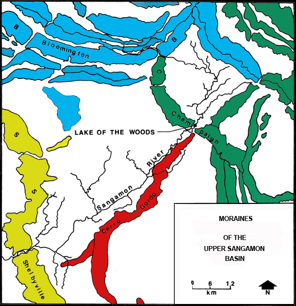
Woodfordian ice began to disrupt its headwaters. The final reconfiguration of the headwaters began less than 20,000 years ago when the Woodfordian glacier reached maximum at the Shelbyville Moraine. As the ice wasted to the north and east, it reestablished a front marked by the Cerro Gordo Moraine. Over this part of the Cerro Gordo's course it forms a relatively straight line from Mahomet to Decatur. As the river passes through the Shelbyville Drift, its east wall is defined by this moraine. How the river penetrated the Champaign Moraine is an unresolved issue. David Reinertson of the Illinois Geological Survey (personal communication) suggests that the gap in the moraine at Mahomet indicates the presence of a subglacial channel issuing meltwater from beneath the glacier's toe. As the rate of flow increased from the wasting Woodfordian ice, the notch was more extensively eroded and assumed its present morphology. These meltwaters also cut the valley to its present configuration in the Cerro Gordo outwash (Cote et al. 1969:14). Above the Champaign Drift, the valley extends roughly 10 miles on to the back slope of the Bloomington Moraine. This condition was precipitated when the Peoria Sublobe of the Woodfordian glaciation readvanced and overrode the northwestern extreme of the Champaign Moraine between 14,000 and 15,000 years ago (Willman and Frye 1970:94). Miller (1973:28) states that in the ensuing 14,000 years the river valley has remained quite stable with slow rates of lateral migration and floodplain sedimentation (0.21 mm/yr). Within the park the valley is never more than 400 m in width.


SOILS


The soils of the research area are formed on the gray, clayey till of the Champaign Drift. This till also contains a wide variety of rock types in differing sizes. The rocky material was plucked from bed rock surfaces to the north and east and transported here by the flowing glacial ice. One interesting manifestation of this process is the presence of Attica-type chert, presumably from a source near Attica, Indiana, in Cerro Gordo outwash. The soil proper is principally formed in the thick mantle of Peoria loess that blankets the area to a typical depth of four feet (Wascher et al. 1960:44) - exceptions are the floodplain soils which are formed in alluvium. The silt-sized, wind-borne loess had its source in the terminal Wisconsinan valley trains of the Illinois and Mississippi Rivers. During each ice age great quantities of silt (rock flour) were transported into the river systems by meltwater. In the summer months the rivers became muddy torrents, often choked by this and other debris. In the colder winter months the meltwater was curtailed and these water borne deposits were then exposed to the prevailing westerly winds. Great winter dust storms occurred that redeposited these materials to the east. The depth of the loess decreases along a generally west-to-east gradient. It is nearly ninety feet thick near Havana, is less than five feet in the area of Mahomet, and is only two feet in eastern Champaign County (Piskin and Bergstrom 1967:19). The wind also sorted the silts by particle size with coarser grained elements to the west and finer grained materials to the east.

The soils of the park form a complex mosaic that include eighteen described series (Mount 1982). Three distinct soil associations can be observed (Hallbick and Alexander 1970). The first is the Colo-St. Charles- Miami. Colo, a very dark gray silty clay loam (SiCL) is a poorly drained, moderately permeable soil of the Sangamon floodplain. It extends from river's edge to the valley wall where it is truncated by the light colored soils of the slope. Where the slope is not too great, soils like St. Charles (SiL on slopes of 1% to 5%) are found. They are moderately well drained and moderately permeable. Where the valley wall is steeper, soils of the Miami series (SiL on slopes of 5% to 25%) are found. These soils are well drained and moderately permeable. Minor soils of this association would include Birkbeck (SiL on slopes of 1% to 5%), Martinsville (L on slopes of 5% to 10%), and Ockley (CL on slopes of 5% to 12%). This soil group is located in areas of the park displaying its boldest topographic relief. They are found in association with such biotic divisions as the river edge, flood plain, and the mixed forest of the slope.

The second soil association is the Drummer-Xenia-Russell. The Drummer soil (SiCL on slopes of 0% to 2%) is poorly drained and moderately permeable. It is found in the sags and waterways of the upland. The high carbon content gives it a rich, black color. The Xenia series is moderately well drained and moderately permeable soil (SiL on slopes of 2% to 5%). It is commonly found above the Drummer soils. The Russell series (SiL on slopes of 4% to 11%) is generally found on the crests of the park's uplands. It is characteristically well drained and moderately permeable. Minor soils of the association would include Camden (SiL on slopes of 1% to 5%), Sabina (SiL on slopes of 0% to 3%), Sunbury (SiL on slopes of 0% to 3%), and Kendall (SiL on slopes of 0% to 3%). This association represents the "forest soil" of the mesic to xeric upland. The strong presence of the Drummer soils leaves open the question of prairie islands and corridors in the oak-hickory forests.

The last association is the Drummer-Parr-Dana. It is found on the western margin of the park. As indicated above, the Drummer is positioned at the bottom of the slopes and fills the drainage ways. Above it is located the Parr series (SiL on slopes of 5% to 10%) consisting of well drained and moderately permeable soils. The morainic crest is capped by the Dana soil (SiL on slopes of 2% to 5%), which is moderately well drained and moderately permeable. A minor soil of this association would be the Raub (SiL on slopes of 0% to 3%). Presumably this association supported the mixed vegetational cover of the savanna community. The savanna represents an ecotone between the corridor forest and the encompassing prairie with the dominant species of each being represented. On the eastern margin of the park this transition from forest to prairie, as indicated by the soils, seems more abrupt.

The genesis of soils is dependent upon a number of critical environmental conditions including climate and vegetation. We will turn next to the first of these.


CLIMATE


The climate of Illinois and the research area is temperate continental. Summers tend to be hot and humid with prevailing winds from the southwest to west. Winters are cold and relatively dry and display predominantly northwest-to-west winds. Major storms and associated weather fronts tend to move rapidly across the area in a west-to-east direction.

Temperature and precipitation are two of the principal factors affecting climate. Data from Urbana, the closest weather reporting station, are presented in Figure 2. The coldest month of the year is January and the hottest is July. The average winter precipitation is 7.42 inches, spring is 12.3 inches, summer is 9.57 inches, and fall is 7.71 inches. The mean annual precipitation at Urbana from 1889 through 1946 was 35.65 inches (Alexander et al. 1974:16-17). Most of the precipitation falls during the growing season which in this area has an average length of 180 days.

Climatologically, Illinois lies at the eastern vertex of a large triangle of cool, dry continental air extending eastward from the Rocky Mountains (Geiss and Boggess 1968). The northern margin is defined by the mean January storm path and the southern boundary of heavy snow, while the southern margin is defined by the mean winter Gulf Coast storm track with its corresponding heavy winter rains (Transeau 1935). The vegetational cover of this region is predominantly prairie grasses, hence Transeau's appellation "Prairie Peninsula." The dominance of prairie species at the expense of forest is significantly influenced by precipitation patterns (Sampson 1922). These patterns would include a dry winter and wet late-spring and summer, as well as periodic summer droughts (F. King 1984:6). The circumstance of dry winters denies trees the necessary moisture for tree growth in the spring while the heavy late-spring and summer precipitation is necessary for warm season grasses (F. King 1984:6). Mount (1982:120) presents data from Urbana indicating that two years in ten will experience a 44% reduction in the April through August rains. This is a condition greatly favoring grass communities with their higher drought tolerance and more readily adjusted phytogeographies.

Of course, we are here speaking of modern weather patterns. The climatic context has changed several times since the glacier's last retreat. As I have previously indicated, good estimates of this event fall in the range of 15,000 to 16,000 BP. While we will momentarily turn to the several lines of evidence that have converged to document the subsequent late Quaternary climatic permutations, let me first outline the sequence of climatic changes that are thought to have occurred (Wendland 1978).

The climate of the Wisconsinan (Dougherty 1968:66-67) was perhaps the coldest of the four Ice Ages, with lowest temperatures coincident with the Woodfordian Substage (20,000-12,500 BP). During the Twocreekan Interstadial (12,500-11,000 BP), the ice retreated from Illinois for the last time under the influence of a temperature regime only 3 to 5 degrees Centigrade lower than today. However, a reversal saw a readvance of the continental ice sheet to a position near Racine, Wisconsin (Valderan Substage, 11,000 to 7,000 BP). These time values are to some extent misleading for central Illinois in that here, after a brief period of cooling, the temperature abruptly moderated at 10,500 BP. From this point the ice to the north was in general retreat until by 7,000 BP the final breakup of the Laurentian Ice Center saw a return of sea level to its current elevation and the installation of modern atmospheric circulation patterns in North America.

The abrupt temperature reversal and general warming at 10,500 BP brackets the initiation of the climatic episode that provides the Holocene its definition. Between 7,500 and 5,500 BP the hemispheric climate reached a temperature maximum 2 to 3 degrees Centigrade higher than it is today (Geiss and Boggess 1968:90). This event has been variously referred to as the Climate Optimum, Altithermal, Thermal Maximum, Atlantic, the Xerothermic Period, and the Hypsithermal Interval (Deevey and Flint 1957). Accompanying this general rise in temperature was a more xeric precipitation regime, at least here in the Prairie Peninsula. Modifications in the precipitation pattern included not only a reduction in the mean annual rainfall but also scheduling and the frequencies of drought. The Hypsithermal event was necessary to the emergence and maintenance of the prairie biota in central Illinois.

After 5,500 BP the climate gradually returned to more mesic conditions with intermittent cooling cycles. The last and perhaps most significant of these was the Neoglacial at 900 to, at least, 400 BP (J. King 1981:60). This relatively cool, wet episode had concluded by the time of significant European contact with North America. During the Historic Period, the Prairie Peninsula


Figure 2. Climatograph Displaying Monthly Mean Temperature (in degrees Fahrenheit) and Precipitation (in inches) for Urbana (data from Schaal 1969:8).


saw only minor climatic oscillations with the temperate, continental conditions of today seemingly firmly stabilized.

Moving now to the regional data that support this interpretation of the late Quaternary climate, I would like to examine five lines of evidence: molluscan fauna, mammalian fauna, soils, alluvial deposition, and palynological analyses. Of these five, the palynological studies are probably most complete and convincing.

Leonard (1974) examines two post-Woodfordian bogs in northeastern Illinois in an effort to identify their depositional chronologies on the basis of molluscan faunas. Strawn Northeast (hereafter referred to as the Chatsworth Bog) is radiocarbon dated by him at 8,940 BP to 2,640 BP with the total sequence inferred as ranging from 10,000 BP to the present. His conclusions are that the rainfall during the post-Woodfordian interval must have been minimal and that little can be said regarding temperature because of the wide variations fresh water mollusks can tolerate. One of his more interesting observations is that at some point in time, the lake associated with the bog was some ten feet higher and created a wave-cut terrace some 200 yards wide (Leonard 1974:22). Whether this was early or late, isolated, short-lived or otherwise remains, unfortunately, unanswered.

The nature of the assemblages of mammalian faunas in the post-glacial period has received some treatment. Work with small faunas suggests (McMillan and Klippel 1981:218-220) that as many as twenty-one species recorded from the Ozarks and the southern boundary of the Prairie Peninsula are today confined primarily to the Canadian and Hudsonian lifezones of Canada. At Christensen Bog, which is located on a terminal Woodfordian landform in Hancock County, Indiana, Graham and his associates (Graham et al. 1983) have recently done work on a mastodon bone bed. The fate of Pleistocene megafauna is an issue of some relevance to archeology in its own right, owing to wide-spread extinctions shortly after humankind's arrival in the region. However, as regards climate, Christen Bog's primary bone bed includes giant beaver (Castor ohioenis), mastodon (Mammut americanum), muskrat (Ondatra zibethicus), caribou (Rangifer tarandus), and white tailed deer (Odocoileus virginianus) in a fir-birch-sedge vegetational matrix at 13,000 to 12,000 BP (Graham et al. 1983:19). The earliest horizon at Christensen is of an open, white spruce grading to tundra parkland and is initiated at approximately 14,000 BP. Today these biota are part of the Northern Boreal Forest and Tundra lying between 50 and 55 degrees north latitude. The giant beaver and mastodon are, of course, now extinct. Prior to their extinction they had likely been displaced from this region by 9,000 BP (Springer and Flemal 1981:92). However, Willman and Frye (1970:164) provide a series of radiocarbon dates for Mammut remains from Champaign County ranging from 7,490 to 9,190 BP. If these values are accurate, Mammut may have been locally present well into the Hypsithermal.

Perhaps no discussion of Late Pleistocene mammalian assemblages would be complete without some reference to the Woolly Mammoth (Mammuthus primigenius). In the fall of 2009 a molar fragment recovered from the excavation of a waterline in a residential subdivision located less than a mile west of the college was brought to our attention. While all such recoveries are by definition suspect, I have little reason to doubt the veracity of the provenience. The find would have come from on or near the crest of the Pesotum Moraine (Willman et al 1975:234-235). The Pesotum is a recessional moraine associated with the Decatur Sub-lobe of the Woodfordian glaciation. While, owing to the item's apparent isolated condition, the possibility of glacial redeposit remains a possibility, the most likely interpretation is that of direct deposition and primary context. If such is the case then the mammoth would have been on this landscape sometime after 16,000 BP and prior to the vegetative succession from open spruce woodland/tundra at 13,800 BP.

Students in my fall 2009 Introduction to Archaeology (ANT 200) class determined that they would research and illustrate the molar (contributors included: Whitney Hoveln, Teri Jolley, Thuy H. Luu, Joseph A. Miebach, Kathryn R. Rumer, Brittany K. Salm, Kyle W. Washburn, and Matthew T. Wilson). We here present some of their effort.


Figure 3. The illustrated faunal element is a fragment of the Left Inferior M3 9-15(?)/24 (Osborn 1942:1142-1145) of Woolly Mammoth (Mammuthus primigenius) recovered from a residential subdivision development located less than a mile west of Parkland College, Champaign County.


(a) Crown superior view. Click on image to enlarge.


(b) Outer view. Click on image to enlarge.


(c) Inner view. Click on image to enlarge.


(d) Proximal view. Click on image to enlarge.


(e) Embedded pebble. Click on image to enlarge.


The analysis of soils presents some interesting issues. Jones and Beavers' (1964) work with opal phytoliths in central Illinois soils indicates that climax stands of Gramineae (grasses) must have been in position by 5133 BP. Deposits left by transpirational processes (Wilding and Drees 1968:97), opal phytoliths are small siliceous bodies located in the leaves and stems of many plants. They are especially pronounced in grasses. Upon the death of the plant they become rather stable elements of the solum. Their aggregate mass in the upper 35 inches of soil formed the foundation of the temporal estimate. Soils also, of course, offer a general guide to native vegetation. In this region the dark, humic mollisols supported prairie and the lighter, less humic alfisols supported forest. Unfortunately, vagaries of soil genesis have been compounded in this region of changing prairie-savanna-forest zones, so that tight correlations are not always possible.

Differential rates of alluviation have been employed in some locales in the Prairie Peninsula to fix varying climatic periodicities. On the southern margin of the Peninsula, McMillan and Klippel (1981:237-238) found that from 9,000 to 4,000 BP the area saw increased erosion during the warmer and drier Hypsithermal. At the Koster Site in the lower Illinois River Valley, Butzer's (1978) studies of erosional/depositional patterns suggest that valley margin hillsides were measurably more xeric from 1,200-950 BP, 2,100-1,900 BP and 9,700-5,000 BP. Miller's work with the Sangamon River (Miller 1973) in the central portion of the valley would seem to have direct implications for the research area. Unfortunately, as I have previously indicated, for the last 14,000 to 15,000 years the channel has been quite stable and floodplain alluviation has been relatively slow. We might speculate that this apparent inconsistency with Butzer's or McMillian and Klippel's work may derive from the low topographic relief of the Sangamon drainage; from slow, rather stable, shifts in the vegetative cover of the basin; or is an artifact of the research itself.

The most compelling evidence for changing late Quaternary climates comes from palynological studies. The most definitive of these as regards the Prairie Peninsula in Illinois is the series of researches by J. King and his associates (see J. King 1981 for a summary). The analysis of pollen assemblages from four sites in the Peninsula (Old Field Swamp in southeastern Missouri; Chatsworth Bog in Livingston County, Illinois; Volo Bog in Lake County, Illinois; and sediments from southern Lake Michigan) demonstrates climatic-vegetational patterns displaying both diachronic and synchronic variation. The sequence for the Chatsworth Bog is of most immediate relevance to this work and is fortunately the best detailed. Chatsworth displays six distinct pollen profiles.

To summarize J. King (1981:51-57), pollen from the basal zone (14,700 to 13,800 BP) at Chatsworth is dominated by spruce (Picea) with lesser amounts of other boreal elements. While the total pollen influx is quite low, King interprets this as typical of tundra ecosystems. He characterizes this profile as open spruce woodland/tundra.

By 13,800 BP spruce is displaced by ash (Fraxinus nigra). This second profile also displays low pollen totals suggesting that the floristic community was still relatively treeless and had a strong tundra component. The temporal range is 13,800 to 11,600 BP.

The third profile dates from 11,600 to 10,600 BP. During this time Picea makes its final retreat, Fraxinus declines significantly, and elm (Ulmus) and oak (Quercus) both increase. As a successional phase, King sees this community as a cool, temperate, deciduous forest stage.

The climate continues to become warmer and drier and culminates at 8,300 BP in the Quercus dominated deciduous forest of the fourth profile. Ulmus, hornbean (Carpinus), and Quercus attain their maximum percentages. Hickory (Carya) pollen increases to about 10% indicating the completion of Carya's migration from areas to the west and south.

The fifth profile begins abruptly at 8,300 BP with major increases in ragweed (Ambrosia) immediately followed by major increases in goosefoot (Chenopodiineaa) and grasses (Gramineae). Carpinus, birch (Betula), Ulmus and Carya all decline in frequency. The NAP (Net Annual Productivity) percentage for grasses is considered typical of prairies. The prairie community dominates the profile from 8,300 to 7,000 BP and suggests a peak in xeric conditions. With some minor adjustments in the composition of the forest community, the prairie persists until the top of the undisturbed sediments is reached (approximately 800 BP). Unfortunately the top 20 cm of the bog were so modified by modern human activity as to make meaningful interpretation impossible.

However, to the north at Volo Bog there is a reemergence of Betula pollen at about 900 BP and continuing to 400 BP. Suggesting the cooler, moister conditions of the Neoglacial, central Illinois may have witnessed the establishment of the "prairie groves." Boggess (1964:261) observes with regard to Trelease Woods, Champaign County, that these mixed mesophytic communities began emerging around 600 BP.

From the undisturbed surfaces of the Volo and the Lake Michigan sites, King (J. King 1981:51; J. King et al. 1976) observes an explosive increase in Ambrosia pollen. Dated at 140 BP, it marks the horizon of major Euro-American land clearing and subsequent agricultural activity. This event brackets the end of the true state of nature in Illinois. In the ensuing 140 years all natural communities in Illinois have undergone radical transformations and degradation. Many of the dominant species on the landscape today are introductions, and this is particularly true of the land that previously supported prairie.

Summarizing the climatic changes of the research area occurring since deglaciation some 15,000 to 16,000 years ago, we find first a period of generally ameliorating temperature. The biotas include an open spruce woodland and tundra. Extinct megafauna like Mammut as well as surviving forms like Rangifer and Odocoileus are present. By 11,600 BP a cool temperate, deciduous forest is in place and Mammut and Rangifer have been displaced with the retreating Boreal Forest. During the next thousand years the climate not only continues to warm but also becomes drier. The relatively xeric oak-hickory forest forms the climax community at 10,600 BP and continues until 8,300 BP. From 8,300 to 5,000 BP we see the local expression of the Hypsithermal Interval, with its associated temperature peaks and precipitation minimums. Prairie-savanna-corridor forest constitute the major vegetational zones. After 5,000 BP, there is a gradual return to more mesic conditions with periodic temperature fluctuations. The most significant of the fluctuations is the Neoglacial at 900 to 400 BP. Floristically this climatic condition resulted in an expansion of the corridor forests and the creation of "prairie groves." By approximately 1840 the prehistoric vegetational patterns were significantly disrupted by human activity.


VEGETATION


I would now like to turn to a more detailed description of the vegetational context of the park. Fortunately, there exists a rich literature on the modern forest communities. The prairie communities, however, are not well described locally, perhaps owing to their major disturbance prior to the advent of scientific interest (Reihmer 1939:87).

This brings us to an issue of some moment. The Bloomington Ridged Plain and the Sangamon drainage have witnessed extensive modification of their natural plant communities during the last 140 years. Known pioneer accounts of the indigenous vegetation lack sufficient detail to be of much use in reconstructing these communities. The only source of information from the period just prior to the time of major disturbance, and one that also displays systematic data collection, is the Government Land Office (GLO) survey.

Government Land Office Survey - The GLO survey provides a useful reconnaissance of the park's vegetational matrix as it existed in 1822. In this year, surveyor Richard T. Holliday, under the contract of Elias and Worton Rector, completed the land survey of what is today known as Mahomet Township (Township 20 North, Range 7 East), Champaign County (Holliday 1822). The actual survey was completed between July 8 and 13. The surveyor was instructed to establish section and quarter section points. Where possible, witness trees were to be employed for relocating these points; otherwise a post was set in a mound at the designated location. When witness trees were used, Holliday generally recorded two for the section corners and one for the quarter sections. Information about the witness trees that is entered in his field notes includes species name, diameter at breast height, bearing from the reference point, and its distance from the reference point. At the completion of each mile Holliday typically provides a rather cryptic synopsis of the vegetation, landforms, and soil. On prairie transects the vegetational reference was simply "prairie" and no attempt was made at identifying species.

In general, the land survey can be employed to provide a gross characterization of the forest community (collection points were no closer than one-half mile) and to identify the geographic extent of the timber/prairie provinces (see Bourdo [1956] and F. King [1978] for discussions of the limitations of GLO survey data in floristic reconstructions).

Potential sources of bias in these data are of concern. William Rector, family member of the above mentioned Rectors, was prosecuted for land fraud in other districts (see Lewis [1979:144] for an informative discussion). How William's activities were expressed by these men remains unknown. I might also add that, while I consider it to be insignificant, Holliday's name is spelled Holiway on the title page of the field notes. However, gossip and clerking errors aside, the detail and speed of Holliday's survey seems remarkable.

A second possible source of bias is more subtle. It would derive from the non-random selection of the witness trees along such dimensions as size and diameter, branching habit, and bark configuration. Because of the variations in sample sizes (Delcourt and Delcourt 1974:640), I employed a one-way analysis of variance test to determine if selection bias was likely. The null hypothesis was that no significant differences existed between the mean distances of the three most common species. The calculations for the F-statistic are summarized on Table 1. The table value for the F-ratio at the .05 level of significance is 3.24, so I conclude that the null hypothesis cannot be rejected and that no significant differences existed in the selection of witness trees. Therefore, the sample would appear to be without selection bias and may be considered representative of the stand.


Table 1. Calculations for the F-Statistic Testing for Significant Differences in the Mean Distances of the Three Most Common Species in the GLO Survey.


Source of Variation Degrees of Freedom Sum of Squares1 Mean Square F2
Between Groups 2 101.47 50.74 0.47
Within Groups 41 4470.39 109.03  
TOTAL 43 4571.86    
1 - Distances are in meters.
2 - Critical value at .05 level of significance = 3.24.


Figure 4 is a reproduction of the GLO's map of the township. (The Lake of the Woods Park lies in parts of sections 9, 10, 11, 14, and 15.) It conforms quite nicely to the data in the field notes. Observe first that two floristic provinces are identified: timber and prairie. Of the 90 reporting stations used in the present study, 36.7% (33) employed a witness tree or trees, and 63.3% (57) were associated with prairie. At only one station was a witness tree used in an area indicated as prairie. This tree, a six inch hickory, was located south of the Champaign Moraine and east of the river, in a locale that would have been savanna. The knolls of the Cerro Gordo Moraine were in prairie (mid- and short grass?). Observe also that the river (referred to as the Sangama in the survey) and the associated forest trends northeast to southwest. The forest is widest along and above the crest of the Champaign Moraine; it is narrowest where the river turns south just below the moraine.

Click on image for larger view.

Figure 4. The Original Government Land Survey Map of Mahomet Township, Champaign County. (Reproduced from a photograph in the files of the Archives of the Urbana Free Library, Urbana).


With regard to the species composition of the prairie nothing can be said. As previously indicated, no data were recorded. The only descriptive references offered by Holliday are to either "rolling" or "level, rich prairie." Interestingly, there is a river bottom prairie indicated between sections 30-31. Holliday describes it as "...level and rich." However, the use of witness trees as quarter section markers (oak and elm with undergrowth the same) suggests a mixed community.

The idea of well developed savanna lying along the park's western margin is only partially supported. Only two stations include the reference "thinly timbered." One is in fact a characterization of a north-south half section line lying just west of the park, between sections 8 and 9. Unfortunately, there is no corresponding reference along the associated east-west transits that would indicate how or where this community joined with the purer stands of timber. An examination of four reporting stations along the boundary between sections 9-16 and 10-15 yielded no patterns in density or basal area. Also there is little information regarding the understory. Undergrowth is described variously as saplings of oak and hickory, vines, and the ubiquitous hazel. There are no references to grasses. Nonetheless, I think that it is safe to conclude that the savanna community did exist in this locale, fluctuating along an east-west gradient in response to fire and varying climatic regimes.

The other locus of possible savanna is situated along the eastern periphery of the forest's constricted section just below the Champaign Moraine. Because this is also where we find the witness tree in a prairie station, I conclude that savanna was also present in this area.

The analysis of the forest data is presented in Table 2. In this rendering, I have attempted to follow statistical conventions that facilitate direct comparisons to other studies from the Sangamon drainage. Following Rodgers and Anderson (1979:232), only the closest witness tree was used in the computation of mean area and its derivatives. However, in the calculation of density and dominance both witness trees were used when they were available. Turning to the data, note the overwhelming importance of white oak in particular and oaks in general. Clearly, this was an oak forest with other species showing rather weak expression. If these results are compared with the data from other studies (Table 3), differences in the species composition of the various stands become apparent. While oaks are everywhere dominant, their relative importance is variable. Moreover, the importance and diversity of the more minor components of the stands are inversely related to the importance of the oaks. It is the variation in the minor components that provides each stand a unique resource potential.

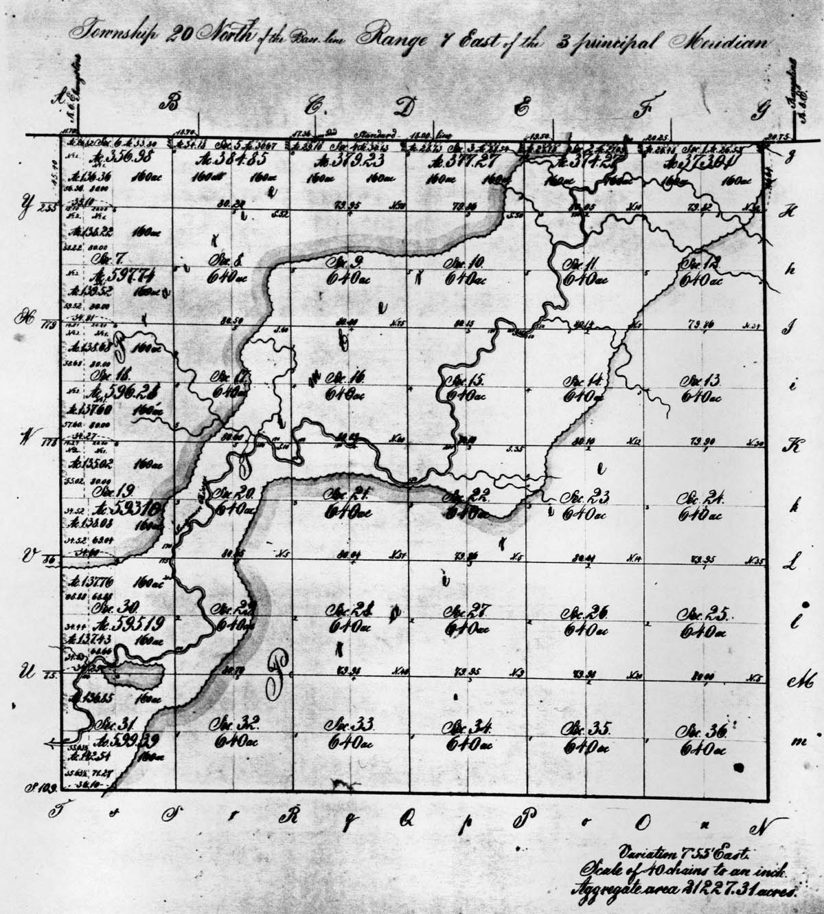
Table 2. Forest Species Identified in the GLO Land Survey (for a review of the statistical measures employed in this analysis the reader is referred to Cottam and Curtis [1956]; Rodgers and Anderson [1979]; and Boggess [1964]).
Species Frequency Relative Density Relative Dominance Importance Value
White Oak 31 58.5 48.8 107.3
Elm 6 11.3 10.9 22.2
Black Oak 5 9.4 11.1 20.5
Red Oak 3 5.7 8.0 13.6
Hickory 3 5.7 6.9
Bur Oak 1.9 7.0 8.9
Hackberry 1 1.9 4.8 6.7
Ash 1 1.9 1.2 3.1
Black Walnut 1 1.9 0.8 2.7
Willow 1 1.9 0.5 2.4
TOTALS 53 100.0 100.0 200.0
Total Distance = 400.9 m   Mean Distance = 400.9/33 = 12.1 m    
Mean Area = (12.1)2 = 146.4 m2   Trees per ha = 10000/146.4 = 68.3    
Avg Basal Area per Tree = 0.2 m2   Total Basal Area = 8.9 m2    


The mean tree density in this section of the Sangamon drainage falls into the range of what Rodgers and Anderson (1979:235) label open forest. The reconstruction of the Pabst Site (Lewis 1979:150) and the lower portion of the Sangamon drainage (King and Johnson 1977:155) display stand densities that fall toward the bottom of this range.

Lastly, we should note that Holliday provides little information regarding the species composition of the forest's undergrowth. Other than saplings of dominant species, he only identifies hazel and vines. Hazel is consistently described from almost all forest reporting stations.

While several problems surround the use of GLO survey data, they provide our best view of the early nineteenth century vegetational landscape. This analysis, in conjunction with the three from elsewhere in the Sangamon basin (Lewis 1979; King and Johnson 1977; and Rodgers and Anderson 1979) provide a critical foundation for the more detailed reconstruction that is to follow.

Floristic Reconstruction - Having earlier in the paper demonstrated a series of paleoclimatic episodes, the following depiction of the research area must be tempered with the knowledge that we are here describing a vegetational distribution and mix that best reflects the climate of the late Neoglacial. During the last 8,300 years, range shifts for the native communities are certainly indicated by the climatic data. Moreover, on the basis of the palynological data, the phytosociologies of the present communities display an inadequate relationship to the flora present in this locale prior to the emergence of prairie at 8,300 BP to be of much use in their interpretation. Nonetheless, for the bulk of the prehistoric sequence, these floristic elements would seem to form the foundation of the park's vegetation.

White and Madany (1978) divide the flora of Illinois into 93 natural communities. Of these perhaps eight were present in the park at the time of the GLO survey. Some like the Low-gradient Creek and Low-gradient River were not addressed by the surveyors. Others like the Wet Floodplain Forest may have been too compact or localized to have received detailed depiction in the field note records. Lastly, the prairie component was ignored with regard to species composition. With these qualifications in mind let us proceed with our reconstruction. (The following material follows White and Madany [1978] and F. King [1984]; see these sources for greater detail on the natural communities of Illinois).

Five environmental classes are represented: Forest, Prairie, Savanna, Stream, and Cultural. Arrayed through these are the eight natural communities.

To summarize each of these:
I. Dry-mesic Upland Forest:

A. Description: A forest community with an average canopy cover in excess of 80% and located on landforms that do not flood. It is the oak-hickory climax in the park and occurs on slopes and exposed uplands with a moderately well drained moisture regime. The plant composition becomes more complex along its lateral margins and in wetter areas.

B. Soils: In the park this community is found on the Drummer-Xenia-Russell soil association and on the better drained elements of Colo-St. Charles-Miami. Boggess and Geis (1967:96) indicate that these soils tend to be more heavily weathered than those supporting the mesic forest. The resulting reduction in the number of nutrient cations limits species diversity.

C. Dominant Species: Table 3 is a comparison of the five dominants for five studies of this community from within the Sangamon drainage. The Historic Period analyses are from Allerton Park (Boggess and Geis 1967) and Hart Memorial Woods (Root et al. 1971). Both are relatively undisturbed climax stands. Hart is two miles north of the Lake of the Woods and Allerton lies some twenty miles to the south-west. The presettlement reconstructions are of Mahomet Township, the Pabst Site (Lewis 1979), and the central Sangamon basin (F. King and Johnson 1977). The Pabst Site is located twenty miles to the west along Salt Creek and occurs in a biophysical context similar to the research area. King and Johnson's work is from the Illinoian till plain below the Shelbyville Moraine.

The comparison is based upon the five species from each setting having the highest Importance Value (Importance Value = relative density + relative dominance). The oaks clearly dominate each stand. The hickories are surprisingly variable in their distribution, with shagbark ranked only ninth at Hart Woods (IV = 2.1). In fact, perhaps the most striking result of this comparison is the degree of variability we find in both species frequency and diversity. The oak-hickory forest was apparently not particularly homogeneous, and its floristic resources were not evenly distributed throughout its range. Moreover, the observation by Root et al. (1971:36) that hickories were reproducing more successfully than the oaks in Hart Woods implies temporal variations in species frequency within a single site. These spatial and temporal variations within the oak-hickory forest likely had implications for prehistoric site selection and function.

Table 3. Importance Values (IV) for the First Five Dominants of the Upland Forest in Five Studies of the Sangamon Drainage.
Species Period/Site
Presettlement Mahomet Township Presettlement Sangamon Basin1 Presettlement Pabst Site2 Historic Hart3 Historic Allerton4
Combined Slope Upland Combined Slope Upland Upland
White Oak 107.3 69.5 50.8 112.1 40.1 98.1 50.3
Black Oak 20.5 67.5 78.8 50.6 26.4 57.4 30.6
Elm 22.2 14.4 12.0 6.7 39.9 14.2 25.2
Hickory 12.6 26.0 41.7 22.7 -- -- 36.0
Basswood -- -- 7.6 3.8 -- -- --
Black Walnut -- 4.1 -- -- -- -- --
Red Oak 13.6 -- -- -- 31.8 11.9 12.3
Black Cherry -- -- -- -- -- 6.5 --
Shingle Oak -- -- -- -- 9.1 -- --

1 - F. King and Johnson (1977)
2 - Lewis (1979)
3 - Root et al. (1971)
4 - Boggess and Geis (1967)

D. Undergrowth: While also displaying varying geographic composition and abundance (Springer 1931:190), common elements of the understory would include: Indian currant, black raspberry, blackberry, red haw, black haw, black cherry, sassafras, elderberry, red bud, and wild crab.

E. Status: The Dry-mesic Upland Forest is the park's primary community.

II. Wet-mesic Floodplain Forest

A. Description: This forest community has an average canopy cover in excess of 80% and is located on the alluvium of the Sangamon Valley. Species are arrayed in terms of their tolerance for flooding. Distribution is from the toe of the valley slope down to near water's edge. It is the major component of the park's bottomland forest.

B. Soils: The soil is the Colo series of the Colo-St. Charles-Miami association. The Colo is a poorly drained, moderately permeable alluvium.

C. Dominant Species: Three studies seem relevant to the park. The only presettlement reconstruction that specifically distills this physiographic unit is by F. King and Johnson (1977). Two recent studies of the area are Bell's (1974) work on the floodplain forest at Allerton Park and Root's et al. (1971) at Hart Woods. Table 4 compares the five leading dominants along the dimension of Importance Value. Observations might include: (1) elm may be less common today because of the ravages of Dutch elm disease (this disaster serves to illustrate the consequences of pathological factors in the internal dynamics of a community); (2) F. King & Johnson's data fail to distinguish between the floodplain and river bank communities; and (3) the startling variations in the situations of silver maple, the hickories, the oaks, and black walnut. These variations are interpreted as indications of the heterogeneity of this community and the site specific quality of resource potential.

Table 4. Importance Value of Five Leading Dominants of the Floodplain Forest From Three Sites in the Sangamon Drainage.
Species: Period/Site
Presettlement Central Sangamon1 Historic Allerton2 Historic Hart3
Elm 44.6 21.6 36.6
Silver Maple -- 75.2 63.8
Sycamore 24.0 -- --
Hickory 19.0 -- --
Oak 46.4 37.5 --
Black Walnut 19.5 -- 11.7
Green Ash -- 10.6 30.1
Hackberry -- 24.6 14.1

1 - Adapted from F. King and Johnson (1977:157).
2 - Adapted from Bell (1974:43). The Importance Values are the average per elevational unit.
3 - Adapted from Root et al. (1971:33).

D. Undergrowth: Plants characteristic of the forest floor would include: gooseberry, red haw, Indian currant, lianas, grape, giant rag weed, and wild rye (Springer 1931:196).

E. Status: The Wet-mesic Floodplain Forest is the dominant element of the bottomland and ranks as the second most expansive forest community in the park.

III. Wet Floodplain Forest:

A. Description: Within the park this community is found in a narrow band along the banks of the Sangamon and its tributaries. In effect, it represents the ecotone between the dominant Wet-mesic Floodplain Forest and the water. While its floristic resources were of perhaps minimal significance to prehistoric peoples, the associated faunas were not.

B. Soils: Saturated segments of the Colo alluvium are the primary soil matrix. Minor expressions of recent gravels and sands are also occasionally encountered.

C. Characteristic Species: Drawing from F. King's (1984:182) description of the community in Illinois and from Jones and Bell's (1974) vascular flora of the Sangamon basin, common species would include: silver maple, cottonwood, sycamore, river birch, black willow, and box elder.

D. Status: The Wet Floodplain Forest is a minor element in the bottomland forest of the park.

IV. Mesic Prairie

A. Description: The extent of prairie communities within the park is problematic, although they were clearly the most significant communities in the region (Vestal 1931). The original GLO survey map of Mahomet Township (Figure 3) indicates that all of the park falls within the florist province labeled Timber. However, Rodgers and Anderson's (1979:235) reconstruction of the presettlement vegetation of McLean County indicates a nearly perfect association between Drummer soils and prairie. Drummer soils are present along the park's periphery. One can also reasonably infer that during the Hypsithermal the corridor forest underwent some contraction and/or opening. Lastly, processes like fire would certainly have produced intermittent dislocations in the forest boundary to the advantage of the prairie. Consequently, I feel safe in including the Mesic Prairie as one of the park's natural communities. Probably always a minor community, it took the form of corridors and islands surrounded by forest. As a measure of its dynamism each individual expression could be either relict or invader (Vestal 1918).

B. Soils: The soil supporting the Mesic Prairie was probably the Drummer Series of both the Drummer-Xenia-Russell association and the Drummer-Parr-Dana association.

C. Characteristic Species: Common plants include big bluestem, Indian grass, prairie dropseed, white prairie clover, and compass plant. More xeric elements would include little bluestem and wetter areas switchgrass and sloughgrass (Voight and Mohlenbrock 1979:6; Vestal 1914:356-358).

D. Status: The prairie was likely a minor element in the park, but the dominant community of the region.

V. Dry-mesic Savanna

A. Description: Savannas represent an ecotone between the forest and the prairie. Prairie grasses provide a closed ground cover while the upper story of trees displays 10% to 80% canopy closure (F. King and Johnson 1984:193). Like the prairie, savanna was a community maintained by fire. The most robust expression of this community within the park was on its western border.

B. Soils: The previously described Drummer-Parr-Dana association, consisting of moderately well drained to poorly drained silt loams and silt clay loams, supported this community.

C. Dominant Species: In Rodgers and Anderson's (1979) presettlement reconstruction of McLean County the leading forest dominants in savanna stations (followed by their Importance Value) were white oak (102.8), black oak (70.3), oak spp. (25.9), hickory spp.(23.9), burr oak (21.2), elm (18.2), and black walnut (11.9). Prairie species of the community include: little bluestem, Indian grass, and cordgrass (F. King and Johnson 1984:194).

D. Status: At this point it is difficult to gauge the extent of the savanna within the park (see page 15). Its rich mix of plants and animals would have rendered it an important resource zone for prehistoric people.

VI. Low-gradient Creek:

A. Description: One of the two aquatic communities within the park, it is found in watersheds of less than 520 square kilometers and creek gradients of less than one foot/mile. The current would be slow with few, if any, riffles. The sediments would be primarily composed of silt and organic material (F. King and Johnson 1984:203).

B. Characteristic species: Common species would include American lotus, arrow-arum, arrowhead, bulrush, common cattail, yellow pond lily, and white water lily (Winterringer and Lopinot 1977).

C. Status: Within the park, the Low-gradient Creek community was a minor floristic element.

VII. Low-gradient River:

A. Description: The major aquatic community within the park, the Sangamon has a gradient of less than one foot/mile with a slow, meandering current. Most sediments are silt and organic matter.

B. Characteristic species: Significant species are the same as for the low gradient creek.

C. Status: The Sangamon is the park's primary aquatic community.

VIII. Cultural Disturbance

A. Description: This community would have been found in association with human activity. Prehistorically, this community would have been quite small and located in a variety of physiographic zones.

B. Characteristic species: Species common to disturbed sites include: Jerusalem artichoke, goosefoot, amaranth, Iva, crab apple and hazel (Jones and Bell 1974), as well as a variety of historically introduced species.

C. Status: Prior to 1840 this was a minor community within the park. Today it is the geographically most extensive.

In conclusion, the park's most expansive presettlement communities included the Dry-mesic Upland Forest, the Wet-mesic Floodplain Forest, and the Dry-mesic Savanna. The floristic resource potential of the Mesic Prairie, the two aquatic communities, and Cultural Disturbance community was probably limited. F. King (1984) provides an excellent analysis of the ethnobotanical implications of the study area, and Jones and Bell (1974) offer an annotated checklist of the vascular flora of the Sangamon catchment.


FAUNA


Our discussion of the park's fauna will be limited to elements of seven taxonomic classes: Mammalia (mammals), Aves (birds), Reptilia (reptiles), Amphibia (amphibians), Osteichthyes (fishes), Pelecypoda (mussels), and Insecta (insects). The various species that are identified are not necessarily exhaustive of their respective classes, but rather reflect our interest in prehistoric utilization.

I. Mammals:

The earliest systematic description of mammals occurring within the upper Sangamon drainage (Kennicott 1855), was, unfortunately, written long after major Euro-American disturbance. Wood (1910) in his classic analysis of the mammals of Champaign County, indicates that bison, elk, marten, fisher, puma and bear were extirpated by 1810; and beaver, coyote, otter, and bobcat by 1860 (deer by 1880 and wolves by 1910). Nevertheless, an examination of the mammalian recovery from several archaeological sites within the drainage reveals no species not also recorded historically (see Table 5).

Table 5 is based upon these studies as well as Hoffmeister and Mohr's (1972) standard work on the mammals of Illinois, and Goff's (1952) 1928 analysis of animal communities in the Sangamon valley. Goff's data were from near White Heath, Piatt County. I would consider Table 5 to be inclusive of the mammalian assemblage of the park for the last 9,000-10,000 years. In saying this I remain aware of, but unconvinced by, the carbon dates for the mastodon remains from eastern Champaign County (Willman and Frye 1970:164).

Several observations can be made regarding this assemblage. First, note that the majority of elements occupy micro-environmental stations that fail to fall neatly into our natural communities. Certainly for most of these species the most favorable habitats are the ecotones or those areas where the natural communities interface. Of the several zones, the forest edge provides the greatest variety of micro-environments favorable to the greatest number of mammals. Consequently, this ectone (the savanna community) displays the highest population densities and species diversity.

Secondly, of the fifty-nine species identified in the assemblage, some twenty-one fail to appear in the archaeological record of the drainage. Three of these are old-world introductions, ten are the bats, and the final eight are simply absent. The latter two situations require further examination. The total absence of bat remains is inexplicable and probably results from recovery bias. Certainly they were available throughout the Holocene where appropriate environmental parameters obtained. With regard to the absence of the eight remaining taxa, a variety of explanations are possible. First, some are smaller (Southeastern shrew, Franklin ground squirrel) and may not have (1) been exploited by prehistoric peoples, (2) preserved well, or (3) been recovered. Secondly, some, like the puma, were large carnivores that may always have displayed low population densities. Lastly, the absence of forms like the coyote, weasel, and southern flying squirrel from the faunas of the four sites used in this analysis may simply be an artifact of such a small sample of sites. The issues raised by these omissions can best be resolved through the inventorying of a larger sample of archaeological sites.

Thirdly, it is important to recognize that the prairie remained without a significant grazing species throughout most of prehistory. The bison does not appear in the records until after the beginning of the Neoglacial (900 BP). Why Bison only then expanded its range east of the Mississippi remains unknown (Purdue and Styles 1986:7). That the niche was open seems well documented by the data. For the prehistoric hunter-gatherer, the absence of a large, herding herbivore, native to the prairie, denied this community a critical and necessary resource potential. The net consequence was to leave the prairie resource poor relative to the forest and forest edge communities.

One last note on the mammals of the park. There presently exists a colony of melanistic eastern gray squirrels east of the river and north of the lake. While Wood's description of the gray is lengthy and includes references to large fall migrations, he makes no reference to melanistic expressions. Hoffmeister and Mohr, on the other hand, indicate that melanistic individuals are frequently found in northern Illinois. Whether the colony is relict or invader is difficult to judge and presents interesting research questions in its own right. The northern association is certainly intriguing. Fifteen years of casual observation suggests that the population is stable at five to eight individuals.

Beyond this I would point out that the current mammal assemblage of the park seems varied, stable and healthy. After being absent from the county for the better part of 100 years, beaver, deer, and coyote - or what Wood refers to as the prairie-wolf - can now be regularly observed. Moreover, to the delight of sociologists, there are even periodic rashes of puma or mountain lion "sightings."

Table 5. Historically Reported Mammals, Preferred Habitats, and Presence in the Archaeological Record.
Species1: Preferred Habitat: Found in Archaeological Context2 :
Oppossum Forest/wooded streams Yes
Shorttail shrew All terrestrial environments Yes
Southeastern shrew Open forest/forest edge No
Least shrew Forest edge/prairie Yes
Eastern mole All upland habitats Yes
Star-nosed mole All upland habitats No
Little brown bat Roosts in trees No
Keen bat Roosts in trees No
Indiana bat Roosts in trees No
Small footed bat Roosts in trees No
Silver haired bat Roosts in trees No
Eastern pipistrel Roosts in trees No
Red bat Roosts in trees No
Big brown bat Roosts in trees No
Hoary bat Roosts in trees No
Evening bat Roosts in trees No
Raccoon Wooded bluffs/floodplain Yes
Marten Dense forest Yes
Fisher Floodplain forest Yes
Least weasel Stream borders/dry prairie No
Longtail weasel Stream borders/dry prairie No
Mink Along all water courses Yes
River otter Sangamon Yes
Badger Dry to mesic prairie Yes
Striped skunk Open forest/forest edge Yes
Black bear Floodplain forest Yes
Domestic dog (see Note 3 below) Yes
Timber wolf Wooded bluffs/forest Yes
Coyote Forest edge/prairie No
Red fox Wooded bluffs/forest edge Yes
Gray fox Dense forest Yes
Puma Dense forest No
Bobcat Dense forest/wooded bluffs Yes
Woodchuck Wooded bluffs/forest Yes
Thirteen-lined ground squirrel Dry prairie Yes
Franklin ground squirrel Dry to mesic prairie/forest edge No
Eastern chipmunk Wooded bluffs/river bottoms Yes
Eastern gray squirrel Dense forest/river bottoms Yes
Eastern fox squirrel Open forest/forest edge Yes
Red squirrel Dense forest Yes
Southern flying squirrel Dense forest/wooded bluffs No
Plains pocket gopher Prairie Yes
Beaver Sangamon/wooded streams Yes
Deer mouse Prairie Yes
White footed mouse Wooded bluffs/floodplain Yes
Golden mouse Floodplain forest Yes
Southern bog lemming Open forest/floodplain Yes
Meadow vole Wet meadows/floodplain forest Yes
Prairie vole Prairie/forest edge Yes
Pine vole Forest Yes
Muskrat Sangamon/streams/prairie sloughs Yes
Norway rat Cultural disturbance Introduced
Black rat Cultural disturbance Introduced
House mouse Cultural disturbance Introduced
Meadow jumping mouse Wooded streams Yes
Eastern Cottontail All open habitats/forest edge Yes
White tailed deer Forest/forest edge/thickets Yes
Elk Open forest/wooded streams Yes
Bison Prairie/forest edge Yes

1 - See Appendix for scientific names.
2 - Compiled from Lewis (1979), Parmalee and Klippel (1983), Parmalee and Bogan (1981), and Purdue and Styles (1986).
3 - The reference here is to varieties associated with prehistoric peoples.

II. Birds:

It is beyond the scope of the present inquiry to provide an inclusive listing of the many avian forms to be found within the study area. Bohlen (1978:12) indicates that 383 species are documented for the state. The Champaign County Audubon Society's Christmas bird count (Bob Chapel, personal communication) has ranged from 51 to 63 species, with 60 being typical. The total number of observed species for the county would number in excess of 200. The species identified in Table 6 do little more than suggest the range of variation present in these three environmental zones prior to significant Euro-American disturbance. All of these birds can still be observed within the Sangamon basin (most are common to abundant) with the exception of three galliformes: wild turkey, ruffed grouse, and greater prairie chicken. The turkey and grouse were extirpated in the county in the nineteenth century and the prairie chicken (Yeatter 1943:379) by the 1930's. (The turkey is presently expanding its range and is likely to be back in the lower valley within five years).

With regard to the water birds, none can be said to be a true winter resident, with perhaps the mallard and kingfisher lingering longest and returning earliest. The annual spring and fall migrations precipitate seasonal concentrations of large numbers of the aquatic fowl. Their extensive exploitation by prehistoric peoples is well documented from sites like Pabst (Lewis 1979:182).

The two terrestrial habitats (forest and prairie) display their greatest species diversity and population densities along their common border. The turkey and prairie chicken serve as illustrations. Price et al. (1984:200) observes that while the turkey is associated with the oak-hickory forest, the forest edge provides food resources not otherwise available in mature forest. Mosaics of forest and field are the bird's preferred situation. Conversely, Yeatter's (1943:402-3) analysis of the stomach contents of prairie chickens from Jasper County indicates that while grassland food resources were most extensively exploited, fruits, like wild black cherry, dogwood and hawthorne, and mast (acorns) were also important. For the opportunistic predator, the forest-prairie ectone was the terrestrial context of maximum avian food potential. This is, of course, the same condition that was observed for mammals.

For the avian community of the forest, niches are structured vertically as well as horizontally. The species of the canopy (pileated woodpecker, yellow-throated warbler) were never very heavily exploited prehistorically. An exception would be the measurable presence of raptors (Lewis 1979:182) from central Illinois sites. The segment of the community that occupied the forest floor (wild turkey, ruffed grouse) were most accessible to human hunters and were undoubtedly the most important food resources. In general, we would have to say that human selection of avafuana focused on relatively large forms that occupied niches extending to the land's (or water's) surface.

A few observations regarding the natural histories of birds and human exploitation are in order. In the lives of all organisms there are patterns and periodicities. Birds are no exception. Behavioral structures may also represent vulnerabilities that can work to the advantage of the hunter/collector. All other things being equal, this becomes a critical factor in resource selection and its timing. One periodicity of major significance for birds would be the seasonal concentrating of certain species as an element of their migratory behavior. We think immediately of the geese and ducks during their fall and spring movements. Terrestrial forms like the blackbirds and passenger pigeons would also have displayed this behavior.

A second pattern of importance would be tight flocking. For some species (turkey, bobwhite) the flocking is not just seasonal, rather it derives from their gregarious natures. At all times of the year we would expect to find them in groups, with the winter flocks being even larger. This condition, of course, can maximize the predator's position. All of these flocking patterns can be further affected by atmospheric events like blizzards which tend to enhance concentrations near environmental stations that provide cover and food.

The last important behavioral structure would be that associated with reproduction and nesting. For species like the turkey and prairie chicken, spring is the season of courtship. During this time the male and, to a lesser extent, the female display much more predictable behaviors, engage in daily visits to strutting and booming grounds, can be brought to the call, and are generally less timid and more aggressive (Schorger 1966:251; Hunter 1977). The male is at this time particularly vulnerable to many predators. For the hens, eggs and chicks of these same species, as well as other ground nesters, the window of greatest vulnerability is later in the reproductive cycle during nesting (Yeatter 1943:392; Schorger 1966:265). The central problem here is mobility. The eggs cannot move by themselves and the hen cannot move them effectively; the chicks display limited running ability and are flightless; and the hen will remain on the nest with considerable tenacity when incubation is advanced (Schorger 1966:266; Yeatter 1943:390). In general, we would find the behavior of birds presenting differential opportunity structures for the human predator.

One last observation regarding human predation on avafauna concerns the use of domestic dogs. For at least the last 4,500 years, the dog has been present within the Sangamon basin (Lewis 1979). That these animals were also employed in bird hunting and nest raiding seems highly probable even though it is difficult to document through the archaeological record.

Table 6. Birds Representative of Several Habitats within the Park.

I. Aquatic (Sangamon, streams, prairie sloughs)
Great blue heron Lesser scaup
Whistling swan American coot
Canada goose American golden plover
Mallard Killdeer
Wood duck Belted kingfisher
II. Forest (floodplain, upland)
Red-shouldered hawk Blue jay
Broad winged hawk American crow
Bald eagle Black-capped chickadee
Bobwhite Tufted titmouse
Wild turkey White-breasted nuthatch
Ruffed grouse Wood thrush
Great horned owl Various warblers
Barred owl Cardinal
All woodpeckers Slate-colored junco
III. Prairie
Rough-legged hawk Dickcissel
Greater prairie chicken Grasshopper sparrow
Sandhill crane Savannah sparrow
Upland sandpiper Redwinged blackbird
Morning dove Eastern meadowlark

III. Amphibians and Reptiles:

Within the state, amphibians are represented by salamanders, frogs, and toads; reptiles include turtles, lizards and snakes. In the definitive herpetological studies of Illinois, Parmalee (1954:3; 1955:5) identifies 93 species and subspecies and Smith (1961:Forward) lists 94. The research of greatest relevance to the park was conducted by Smith (1947) along the Shelbyville Moraine. His study area extended to within 30 miles of our own. A qualification of unknown magnitude regarding the direct application of his results to the park centers on the fact that none of his rivers are part of the Illinois basin. The drainages of his study area empty into either the Wabash or Mississippi. We might, as a consequence, expect the presence of more western species in our assemblage. Such species might include, for instance, the great plains garter snake (Goff 1952), the yellow mud turtle, and the Strecker's chorus frog (Parmalee 1954;1955). Keeping this concern in mind, Table 7 lists those species identified by Smith (see Table 7, Notes 2 and 3) as occurring within what he termed "prairie." Geographically this label corresponded to the Bloomington Ridged Plain and its associated prairie - corridor forest - aquatic communities. The table also indicates preferred habitats. The check-list includes eight amphibians and 21 reptiles.

An examination of the characteristic habitats of these fauna indicates several structural features. The first is that aquatic contexts are associated with most of the amphibians, all but two of the turtles, and with two of the snakes (15 species). Secondly, snakes and the one lizard, Ophisaurus ventralis, show a distinct preference for terrestrial situations, and are evenly split between forest and prairie. Thirdly, the only terrestrial amphibian, the toad, can be found in both forest and prairie. Lastly, of the two terrestrial turtles, Terrapene carolina is common to the forest and Terrapene ornata is typical of prairie.

How our list might vary from the assemblage that was present prior to Euro-American disruption is unknown. Smith's review of the first statewide catalog (Davis and Rice 1883) concludes that several species were no longer to be found in the state (Smith 1961:3). One line of evidence for the presence of other species in the Sangamon Valley comes from the Pabst Site where Lewis (1979:185) recovered an additional species of turtle and seven species of snakes. These eight taxa are identified on Table 8. An examination of habitats reveals that six were common to upland locales, the significant disruption of which may explain their disappearance and resulting absence from the historic record. If these taxa are combined with our previous list, the assemblage at the time of contact might have been eight species of amphibians and 29 species of reptiles. While this combined list might be more representative, it still should not be considered inclusive.

Table 7. Amphibians and Reptiles of the Park and Preferred Habitats.

Species - Common Name , Preferred Habitat1

Amphibians:
Necturus maculosus maculosus - Mudpuppy , Aquatic
Hyla crucifer crucifer - Spring peeper , Floodplain forest
Hyla versicolor versicolor - Common tree frog , Floodplain forest
Acris gryllus blanchardi - Cricket frog , Aquatic
Pseudacris nigrita triseriata - Striped tree frog , Streams/marshes
Rana catesbeiana - Northern bull frog , Aquatic
Rana pipiens pipiens - Leopard frog , Aquatic
Bufo terrestris americanus - American toad , Terrestrial
Reptiles:
Ophisaurus ventralis - Glass snake , Open forest
Coluber constrictor flaviventris - Blue racer , Terrestrial
Elaphe vulpina vulpina - Fox snake , Uplands
Lampropeltis calligaster calligaster - Prairie king snake , Prairie
Lampropeltis triangulum triangulum - Common milk snake , Terrestrial
Natrix grahamii - Graham's water snake , Aquatic
Natrix kirtlandii - Kirtland's water snake , Floodplain forest
Natrix sipedon sipedon - Common water snake , Aquatic
Thamnophis radix - Great Plains garter snake2 Prairie
Thamnophis sirtalis sirtalis - Common garter snake , Prairie
Sistrurus catenatus catenatus - Eastern massasauga , Terrestrial
Sternotherus odoratus - Musk turtle , Aquatic/mud bottom
Chelydra serpentina - Snapping turtle , Aquatic/mud bottom
Emys blandingii - Blanding's turtle , Semi-aquatic
Terrapene carolina carolina - Common box turtle , Forest
Terrapene ornata - Ornate box turtle , Prairie
Graptemys geographica - Geographic turtle , Aquatic/mud bottom
Graptemys pseudogeographica
pseudogeographica - False map turtle , Aquatic/strong current
Chrysemys picta marginata - Painted turtle , Aquatic/mud bottom
Pseudemys scripta troostii - Troost's turtle , Aquatic/mud bottom
Amyda spinifera spinifera - Spiny soft-shelled turtle , Sangamon

1 - Parmalee (1954,1955); Smith (1947,1961); and Cahn (1937).
2 - This species was identified by Goff (1952) 15 miles down the Sangamon from the park.
3 - The author's personal identification of a specimen from the park.

Table 8. Additional Reptile Species Recovered from the Pabst Site.1

Species							Preferred Habitat
========                                                ==================
Natrix rhombifera - Diamondback water snake		Aquatic 
Masticophis flagellum - Whip snake			Upland Prairie 
Elaphe guttaga - Rat snake				Upland Prairie 
Pituophis catenifer - Bull snake			Upland Prairie 
Lampropeltis getulus - Speckled kingsnake		Upland Forest 
Ancistrodon contortrix - Copperhead			Upland Forest 
Crotalus horridus - Timber rattlesnake			Forest 
Kinosternon spp. - Mud turtle				Aquatic/mud bottom 
1 - Lewis (1979:185)

IV. Fishes:

Three catalogs of the fish of Champaign County have been generated. Forbes and Richardson in 1899 collected and identified 65 species (Forbes and Richardson 1908). Between 1928 and 1929 Thompson and Hunt (1930) collected and identified an additional 10 species. In 1959, Larimore and Smith (Larimore and Smith 1963), building upon these prior researches, compiled a total of 90 confirmed species and an additional four hypothetical taxa. Of these only 67 were taken and recorded in the Sangamon drainage (Larimore and Smith 1963:334). However, of the six drainages in the county, the Sangamon displayed the highest level of species diversity and had the highest incidence (seven) of fish unique to a drainage. Three of the 67 species - the yellow bass, European carp, and redear sunfish - are old world introductions. This results in a total of 64 native species documented in the modern literature. Other native species likely had prehistoric ranges extending into this region of the Sangamon basin. For instance, Lewis (1979:186) recovered bowfin, a species not found in the current catalog, from the Pabst Site.

Table 9 lists species characteristic of the several stream habitats common to this portion of the Sangamon. Following Larimore and Smith (1963:313-317), the drainage can be divided into three major zones: rivulets and small creeks, large creeks, and the main channel of the river. The large creeks and the river can be further interpreted in terms of varying types of riffles and pools.

Both Thompson and Hunt (1930) and Larimore and Smith (1963) demonstrate that: (1) species diversity increases downstream; (2) fish densities decrease downstream; (3) the average size of the fish increases downstream; and (4) patterns (2) and (3) are essentially offsetting so that the total quantity of fish flesh per area unit remains essentially constant and independent of stream size. Seasonal patterns are also apparent. As the late summer-early fall dry season advances, water levels drop, and the fish congregate in pool refugia. Similar pooling occurs in backwater sloughs and oxbows subsequent to the recession of spring floods. Many fish are trapped and die by the time these impoundments dry up during the summer. Many species also engage in seasonal migration, moving to relatively deeper water during the cold months (Han Kinson 1919) and returning in spring "runs." During the winter, fish activity is significantly reduced. For instance, the reduction in bottom-feeding and the turbidity it produces is so great that the river is described as "winter clear." The change in turbidity levels is apparent to even the most casual observer.

In general the fish population of the study area is large and diverse. Prior to disturbance it probably included more species than are identified in Table 9. Several distributional and behavioral patterns can be identified.

Table 9. Fish Species Characteristic of Sangamon Drainage Habitats.1

I. Rivulets and Small Creeks
Etheostoma spectabile - Northern orangethroat darter
Semotilus atromaculatus - Northern creek chub
Fundulus notatus - Blackstripe topminnow
Pimephales notatus - Bluntnose minnow
Catostomus commersoni, young-White sucker
Lepomis cyanellus, young-Green sunfish
Ictalurus natalis, young-Yellow bullhead
Ictalurus melas, young-Black bullhead
II. Large Creeks
A. Riffles: Sand and Fine Gravel
Etheostoma spectabile - Northern orangethroat darter
Notropis dorsalis - Central bigmouth shiner
Campostoma anomalum - Central stoneroller
Phenacobius mirabilis - Suckermouth minnow
B. Riffles: Gravel and Rubble
Etheostoma flabellare - Fantail darter
C. Pools: Shallow, Moderate Current
Notropis chrysocephalus - Central common shiner
Hybopsis biguttata - Hornyhead chub
Semotilus atromaculatus - Northern creek chub
Notropis stramineus - Sand shiner
Notropis spilopterus - Spotfin shiner
Pimephales notatus -- Bluntnose minnow
Etheostoma nigrum - Eastern johnny darter
Moxostoma spp., young-Redhorse
Carpiodes spp., young-Carpsucker
Hypentelium nigricans, young-Northern hog sucker
Percina maculata - Blackside darter
Carpiodes cyprinus - Central quillback carpsucker
Hybognathus nuchalis - Western silvery minnow
Notropis lutrensis - Red shiner
D. Pools: Deep, Sluggish
Lepomis megalotis - Central longear sunfish
Micropterus dolomieui - Northern smallmouth bass
Ambloplites rupestris - Northern rock bass
Esox americanus - Grass pickerel
Erimyzon oblongus - Western creek chubsucker
Notemigonus crysoleucas - Golden shiner
Lepomis humilis - Orangespotted sunfish
Pimephales promelas - Northern fathead minnow
Aphredoderus sayarus - Pirateperch
Lepomis macrochirus - Northern bluegill
Ictalurus natalis - Yellow bullhead
Ictalurus melas - Black bullhead
Noturus gyrinus - Tadpole madtom
Notropis umbratilis - Redfin shiner
Lepomis cyanellus - Green sunfish
Fundulus notatus - Blackstripe topminnow
III. Sangamon River
A. Riffles: Sand and Gravel
Notropis whipplei - Steelcolor shiner
Notropis dorsalis - Central bigmouth shiner
B. Riffles: Boulders and Rubble
Noturus flavus - Stonecat
Etheostoma zonale - Eastern banded darter
C. Pools: Shallow, Moderate Velocity
Percina phoxocephala - Slenderhead darter
Carpiodes velifer - Highfin carpsucker
Percina caprodes - Logperch
Lepomis megalotis - Central longear sunfish
D. Pools: Deep, Sluggish
Dorosoma cepedianum - Gizzard shad
Micropterus salmoides - Northern largemouth bass
Pomoxis annularis - White crappie
Pylodictis olivaris - Flathead catfish
Lepomis macrochirus - Northern bluegill
Aplodinotus grunniens - Freshwater drum
Ictalurus natalis - Yellow bullhead
Ictalurus melas - Black bullhead

1 - Adapted from Larimore and Smith (1963) and Han Kinson (1919).

V. Mollusks:

The mollusks of the upper Sangamon are numerous and varied. They include both aquatic and terrestrial faunas. Based on data collected between 1906 and 1911 in Champaign and Piatt Counties, Zetek (1918:152) suggests that the total number of species would "... probably be over two hundred." From collections of mussels made from the Sangamon between Monticello and White Heath, Piatt County, Zetek (1918:154) records the species listed in Table 10.

Parmalee (1967:13) notes that naiad populations respond to a variety of environmental circumstances including the depth of the water, the velocity of the current, and the nature and composition of the bottom. In general, there is a succession of types as one descends a drainage system. This succession is accompanied by a general increase in size and weight both within and between species.

The human exploitation of these fauna, both prehistorically and historically, has been extensive. Prehistoric peoples (Parmalee and Klippel 1974) ate the animal's fleshy parts, used the shells for both utilitarian and symbolic/decorative functions, and collected the pearls (virtually all fresh-water mussels are capable of producing pearls). Historic Euro-American populations have tended to focus on the pearls and the utilization of the shells as source material for buttons. Parmalee (1967:2) records that the rivers of the Illinois basin, specifically including the Sangamon, were major extraction loci for the national button industry that flourished during the first half of the twentieth century.

While no literature dealing specifically with the aquatic snails of the Sangamon drainage was uncovered, Zetek (1918:156) does provide some insight into the terrestrial snail assemblage. His observations are with regard to two mesic "prairie groves" located near Champaign (Brownfield and Cottonwood Woods). He provides no information on specific habitat preferences or relative frequencies. Table 11 lists the identified species. While the prairie grove community does not exist in the park and while these two groves drain into the Wabash, they nonetheless suggest some of

Table 10. Mussels of the Sangamon River, Piatt County.1

1. Dominant species:
Amblema undulata
Quadrula pustulosa
Fusconaia rubiginosa
Fusconaia coccinea
Tritogonia tuberculata
Eurynia fasciata
2. Characteristic species:
Lampsilis ventricosa
Lampsilis anodontoides
Strophitus edentulus
Anodonta grandis
Anodontoides ferussacianus subcylindeaceus
Lasmigona costata
Lasmigona complanata
Alasmidonta calceola
Alasmidonta marginata

1 - Adapted from Zetek (1918:154).

the species parameters that we might encounter within our study area. The checklist includes a total of 27 species. The presence of both aquatic and terrestrial snail shells from prehistoric sites in Illinois (Parmalee 1968:107) lends strong support for an interpretation of conscious exploitation. Functions were likely both dietary and ornamental.

Table 11. An Inventory of Terrestrial Snails from Two Prairie Groves in Champaign County.1

Polygyra elevata
Philomycus carolinensis
Polygyra zaleta
Pyramidula alternata
Polygyra pennsylvanica
Pyramidula solitaria
Polygyra thyroides
Pyramidula perspectiva
Polygyra hirsuta
Helicodiscus parallelus
Circinaria concava
Sphyradium edentulum
Zonitoides arboreus
Succinea avara
Zonitoides mimusculus
Strobilops labyrinthica
Zonitoides nitudus
Gastrocopta contracta
Vitrea indentata
Gastrocopta tappaniana
Vitrea hammonis
Gastrocopta holzineri
Paravitrea significans
Vertigo tridentata
Euconulus chersinus
Carychium exile
Agriolimaw campestris

1 - Adapted from Zetek (1918).

VI. Other Invertebrates:

The analysis of other invertebrate forms such as insects, segmented worms and crayfish are rarely encountered in the literature of archeology. There are several likely reasons for this including the highly technical nature of the several classification schema, the many species known to exist, and the poor preservation of these forms in the archaeological record. The baseline literature also remains remote to the present author. Nevertheless, these fauna probably played an important role in human settlement-subsistence systems. Support for this conclusion can be found archaeologically, ethno-historically, and historically. Let me illustrate by briefly turning to the case of insects.

Patty Jo Watson (1969:50-55) reports that a large grasshopper, a beetle pupa and several mites were identified in the analysis of paleo-feces from Salts Cave, Kentucky. The temporal horizon for these deposits is roughly 2300 to 2700 B.P. The clear implication is that these organisms had been purposefully ingested. Skinner (1910) details ethno-historical data on some of the culinary practices of several Native American societies. Among some of these peoples he finds a robust dietary interest in such things as raw, boiled, or roasted fly larvae, ants, grasshoppers, crickets and locusts. He is also able to document the consumption of worms. Lastly, in a 1939 article, Vestal writes about environmental factors influencing the homesteading of the prairie. In it he provides the following quote from an 1884 history of Cumberland County by J. T. Battle:

... the swarms of "greenheaded flies" which infested the prairie practically disbarred the traveler from using the larger part of the day in prosecuting his journey. The unfortunate animal exposed to their attack would be covered with these voracious insects ... and such was the vigor and effectiveness of their attacks that no animal could sustain it long ... work and travel were practically suspended from nine o'clock until ... evening. The timber was free from these pests and the early trails led along its border, but even these trails were abandoned to the heat of the day. Traveling was consequently done principally at night, which gave rise to very serious experiences (Vestal 1939:86).

Vestal also cites Jim Hall, writing in the July, 1831 edition of the Illinois Monthly Magazine, as indicating that during the heat of the summer animals would be driven from the "buffalo paths" by prairie flies. The prairie or greenheaded flies being referred to were probably small biting horseflies and deerflies of the genus Chrysops. They and other insects, like mosquitoes and grasshoppers, may have seasonally constituted the major faunal biomass of the prairie. The large number of parasitic insects on the prairie during the warm season likely also impacted prehistoric exploitation in a limiting fashion. Certainly the potential importance of insects as both an element of diet and a pest deserves greater attention by archeologists working in the region. The same admonition can also be directed to many of the other invertebrates of the park.

VII. Conclusions

In concluding our reconstruction of the faunal assemblage of the park perhaps three observations are in order. The first of these is the magnitude and complexity of the assemblage. While we have identified approximately 240 species, in most cases the checklists include only characteristic species and cannot be considered inclusive. Moreover, in following archaeological conventions, we have made only a partial attempt at a systematic delineation of multicellular invertebrates and no attempt at all at microbes. While this analysis has been guided by a concern with prehistoric faunal exploitation, the thousands of unidentified species were demonstrably important to the character of the area's biological matrix. These residual taxa deserve greater attention by archeologists.

The second observation focuses on the prehistoric resource potential of the several environmental zones. Certainly the aquatic communities would have seasonally been of great economic potential. Of the terrestrial communities, the forest edge or savanna would have displayed the highest levels of species diversity and faunal density. In that the prairie province was devoid of a large herbivore throughout most of prehistory, it was probably always resource poor relative to the forest.

Lastly, with the exception of the mammals and mussels, little professional attention has been directed toward the regional expressions of these animal classes during late Pleistocene and early Holocene times. The best solution to a fuller understanding of how climatic and vegetational changes may have affected the composition of the faunal assemblage can only come through more research. Certainly much more work is needed.


CONCLUSIONS


In the preceding pages we have attempted to provide a brief overview of the very rich native environment of the Lake of the Woods Park and the upper Sangamon basin. In doing so our attention has centered on five critical environmental conditions: geomorphology, soils, climate, vegetation, and fauna. To summarize:

(1) The Lake of the Woods Park lies along the crest of the Champaign Moraine. A terminal Woodfordian event, it dates from approximately 16,000 years ago. The Sangamon River rises to the northwest on the Bloomington Moraine and breeches the Champaign Moraine just below the park. The drainage system is weakly entrenched and has been relatively stable through the ensuing millennia.

(2) The soils of the park are primarily formed on glacial outwash that was subsequently covered by loess to an average depth of four feet. Three distinct soil associations are recognized: (a) the Colo-St. Charles-Miami; (b) the Drummer-Xenia-Russell; and (c) the Drummer-Parr-Dana. Each association is interpreted as supporting a characteristic natural community.

(3) The modern climate of the park is described as temperate continental. Summers are hot and humid while winters are cold and dry. Most of the annual 36 inches of precipitation falls during the late spring and early summer. Data bearing on the issue of paleoclimates suggest that, subsequent to the wastage of the Woodfordian Glacier, climatic conditions ameliorated, reaching a temperature maximum by 8,300 BP. Annual rainfall may also have been reduced or its seasonal distribution modified to favor grasses. This climatic episode, referred to as the Hypsithermal, continued until approximately 5,000 years ago when there was a return to frequently cooler, more mesic regimes. The last of these, the Neoglacial, may have contributed to the emergence of the prairie groves of east-central Illinois.

(4) Our discussion of floristic communities was limited to those found within the park. The reconstruction of the native vegetation of Mahomet Township revealed few differences from those generated for other segments of the Sangamon basin. The most archaeologically significant communities include: the Dry-mesic Upland Forest characterized by oaks and hickories; the Wet-mesic Floodplain Forest characterized by silver maple, elms, and oaks; and the Dry-mesic Savanna characterized by widely spaced oaks and hickories and an understory of prairie grasses.

(5) The faunal assemblage of the study area is both immense and complex. Our discussion provides a systematic overview of the mammals, birds, amphibians and reptiles, fish, and mollusks. The cultural significance of insects is also addressed.

In pursuing this study I have discovered sources of historical data and a literature of the natural history of the upper Sangamon basin that is surprisingly rich and deep. I have not only been interested in modern studies but have searched for nineteenth century statements that include observations about an environment less disturbed than today's. In doing this I have addressed what White and Madany (1978) labeled the Cultural Disturbance Community in an incidental and ad hoc fashion. The next step in the project is to examine the articulation of human culture with the environmental parameters that we have been able to reveal. What should result is a natural history of human activity in the upper Sangamon basin. A natural history of human-kind is a proper application of anthropological archeology.


APPENDIX


CHECKLIST OF MAMMALS
HISTORICALLY REPORTED
IN CHAMPAIGN COUNTY
Lenville J. Stelle
Parkland College
1977
Kingdom:  Animalia 
	Phylum:  Chordata 
		Subphylum:  Vertebrata 
			Class:  Mammalia 
				Subclass:  Theria 
					Infraclass:  Metatheria 
 
Order:	Marsupialia (Marsupials) 
	Family:	Didelphiidae 
		Didelphis marsupials - Opposum 
 
					Infraclass:  Eutheria 
 
Order:	Insectivora 
	Family:   Soricidae (Shrews) 
		Sorex longirostris - Southeastern shrew 
		Cryptotis parva - Least shrew 
		Blarina brevicauda - Shorttail shrew 
Family:	Talpidae (Moles) 
		Scalopus aquaticus - Eastern mole 
		Condylura cristate - Star-nosed mole 
 
Order:	Chiroptera (Bats) 
	Family:	Vestertilionidae 
		Myotis lucifugus - Little brown bat 
		Myotis keeni - Keen bat 
		Myotis sodalis - Indiana bat 
		Myotis subalatus - Small footed bat 
		Lasionycteris noctivagaus - Silver haired bat 
		Pipistrellus subflavus - Eastern pipistrel 
		Lasiurus borealis - Red bat 
		Eptesicus fuscus - Big brown bat 
		Lariurus cinereus - Hoary bat 
		Nycticeius humeralis - Evening bat 
 
Order:	Carnivora (Flesh-eaters) 
	Family:	Procyonidae (Raccoons) 
		Procyon lotor - Raccoon 
	Family:	Mustelidae (Weasels, Skunks) 
		Mustela americana _ Marten 
		Mustela canadensis - Fisher 
		Mustela rixosa - Least weasel 
		Mustela frenata - Longtail weasel 
		Mustela vison - Mink 
		Lustra canadensis - River otter 
		Taxidea taxus - Badger 
		Mephitis mephitis - Striped skunk 
	Family:	Canidae (Wolves, Foxes) 
		Canis lupus - Timber wolf 
		Canis latrans - Coyote 
		Vulpes fulva - Red fox 
		Urocyon cinereoargenteus - Gray fox 
	Family:	Ursidae (Bears) 
		Ursus americanus - Black bear 
	Family:	Felidae (Cats) 
		Felis concolor - Puma 
		Lynx rufus - Bobcat 
 
Order:	Rodentia (Gnawing Mammals) 
	Family:	Sciuridae (Squirrels) 
		Marmota monas - Woodchuck 
		Citellus tridecemlineatus - Thirteen-lined ground squirrel 
		Citellus franklini - Franklin ground squirrel 
		Tamias striatus - Eastern chipmunk 
		Sciurus carolinensis - Eastern gray squirrel 
		Sciurus niger - Eastern fox squirrel 
		Tamiasciurus hudsonicus - Red squirrel 
		Glaucomys volans - Southern flying squirrel 
	Family:	Geomyidae (Pocket gophers) 
		Geomys bursarius - Plains pocket gopher 
	Family:	Castoridae (Beaver) 
		Castor canadensis - Beaver 
	Family:	Cricetidae (Mice, Lemmings and Voles) 
		Peromyscus maniculatus - Deer mouse 
		Peromyscus leucopus - White-footed mouse 
		Peromyscus nuttalli - Golden mouse 
		Synaptomys cooperi - Southern bog lemming 
		Microtus pennsylvanicus - Meadow vole 
		Microtus ochrogaster - Prairie vole 
		Pitymys pineotorum - Pine vole 
		Ondatra zibethicsa - Muskrat 
	Family:	Muridae (Old Word Rats and Mice) 
		Rattus norvegicus - Norway rat 
		Rattus rattus - Black rat 
		Mus musculus - House mouse 
	Family:	Zapodidae (Jumping Mice) 
		Zapus hudsonius - Meadow jumping mouse 
 
Order:	Lagomorpha (Pikas, Hares and Rabbits) 
	Family:	Leporidae (Hares and Rabbits) 
		Sylvilagus floridanus - Eastern cottontail 


Order:	Artiodactyla (Even-Toed Hoofed Mammals) 
	Family:	Cervidae (Deer) 
		Odocoileus virginianus - White-tail deer 
		Cervus canadensis - Elk 
	Family:	Bovidae (Bison) 
		Bison bison - Bison 
 
Order:	Primates 
	Suborder:	Anthropoidea 
		Superfamily:	Hominoidea 
			Family:	Hominidea 
				Genus:	Homo 
					Species:	sapiens 
						Variety:	sapiens 


REFERENCES CITED


Alexander, J. D., J. B. Fehrenbacher, and D. C. Hallbick
1974 Soil Survey: Champaign-Urbana Area, Illinois. University of Illinois Agricultural Experiment Station. Urbana.

Bell, David T.
1974 Tree Stratum Composition and Distribution in the Streamside Forest. American Midland Naturalist 92:35-46.

Berggren, Dwain and Cathy S. Hunt
1979 A Guide to the Geology of the Farmer City Area, De Witt County, Illinois. Illinois State Geological Survey. Urbana.

Boggess, W. R.
1964 Trelease Woods, Champaign County, Illinois: Woody Vegetation and Stand Composition. Transactions of the Illinois State Academy of Science 57(4):261-271.

Boggess, W. R. and J. W. Geis
1967 Composition of an Upland, Streamside Forest in Piatt County, Illinois. The American Midland Naturalist 78:89-97.

Bohlen, H. David
1978 An Annotated Check-list of the Birds of Illinois. Illinois State Museum, Popular Science Series 9. Springfield.

Bourdo, E. A.
1956 A Review of the General Land Office Survey and of Its Use in Quantitative Studies of Former Forest. Ecology 37:754-768.

Butzer, Karl W.
1978 Changing Holocene Environments at the Koster Site: A Geo-Archaeological Perspective. American Antiquity 43:408-415.

Cahn, Alvin R.
1937 The Turtles of Illinois. Illinois Biological Monographs 16:5-209.

Cote, W. E., D. L. Reinertsen, G. M. Wilson, and M. M. Killey
1969 Guide Leaflet Monticello-Mahomet Area. Illinois State Geological Survey. Urbana.

Cottam, Grant and J. T. Curtis
1956 The Use of Distance Measures in Phytosociological Sampling. Ecology 37(3):451-460.

Daugherty, Howard E.
1968 Quaternary Climatology of North America with Emphasis on the State of Illinois. In The Quaternary Of Illinois, edited by Robert E. Bergstrom. University of Illinois, College of Agriculture, Special Publication No. 14:61-69. Urbana.

Davis, N. S. and Frank L. Rice
1883 List of Batrachia and Reptilia of Illinois. Chicago Academy of Science Bulletin 1(3):25-32.

Delcourt, Hazel R. and Paul A. Delcourt
1974 Primeval Magnolia - Holly - Beech Climax in Louisiana. Ecology 55(3):638-644.

Devey, E. S. and R. F. Flint
1957 Postglacial Hypsithermal Interval. Science 125:182-184.

Forbes, Stephen Alfred and Robert Earl Richardson
1908 The Fishes of Illinois. Illinois State Laboratory of Natural History. Urbana.

Geis, James W. and William R. Boggess
1968 The Prairie Peninsula: Its Origin and Significance in the Vegetational History of Central Illinois. In The Quaternary of Illinois, edited by Robert E. Bergstom. University of Illinois, College of Agriculture, Special Publication No. 14:89-95. Urbana.

Goff, Carlos C.
1952 Flood-Plain Animal Communities. American Midland Naturalist 47:487-486.

Graham, R. W., J. A. Holman, and P. W. Parmalee
1983 Taphonomy and Paleoecology of the Christensen Bog Mastodon Bone Bed, Hancock County, Indiana. Illinois State Museum, Reports of Investigations, No. 38. Springfield.

Hallbick, D. C. and J. D. Alexander
1970 Soil Associations of Champaign County, Illinois. University of Illinois, College of Agriculture, Illinois Agricultural Experiment Station. Urbana.

Han Kinson, T. L.
1919 Notes of Life-Histories of Illinois Fish. Transactions of the Illinois State Academy Of Science 12:132-150.

Hoffmeister, Donald and Carl O. Mohr
1972 Fieldbook of Illinois Mammals. Dover Publications, New York.

Holliday, Richard J.
1822 Government Land Office Survey of Mahomet Township, Champaign County, Illinois. Vol. 213:242-285.

Hunter, Joan
1977 Prairie Chickens Boom in Illinois. Illinois State Museum Leaflet, No. 4. Springfield.

Jones, Almut G. and David T. Bell
1974 Vascular Plants of the Sangamon River Basin: Annotated Checklist and Ecological Summary. University of Illinois, College of Agriculture, Agricultural Experimental Station, Bulletin 746. Urbana.

Jones, R. L. and A. H. Beavers
1964 Aspects of Catenary and Depth Distribution of Opal Phytoliths in Illinois Soils. Soil Science Society of America, Proceedings, 28:413-416.

Kennicot, Robert
1855 Catalogue of Animals observed in Cook County, Illinois. Transactions of the Illinois State Agricultural Society 1:1853-54, pp. 577-595.

King, Frances B.
1978 Additional Cautions on the Use of the GLO Survey Records in Vegetational Reconstructions in the Midwest. American Antiquity 43:99-103.
1984 Plants, People, and Paleoecology. Illinois State Museum, Scientific Papers, Vol. 20. Springfield.

King, Francis B. and Judith B. Johnson
1977 Presettlement Forest Composition of the Central Sangamon River Basin, Illinois. Transactions of the Illinois State Academy of Science 70:153-163.

King, James E.
1981 Lake Quaternary Vegetational History of Illinois. Ecological Monographs 51:43-62.

King, James E., Jerry A. Lineback, and David L. Gross
1976 Palynology and Sedimentology of Holocene Deposits in Southern Lake Michigan. Illinois State Geological Survey, Urbana.

Larimore, Weldon and Philip W. Smith
1963 The Fishes of Champaign County, Illinois, as Affected by 60 Years of Stream Changes. Illinois Natural History Survey Bulletin 28:299-382. Urbana.

Leonard, A. Byron
1974 Chronology and Molluscan Paleontology of Two Post-Woodfordian Bogs in Northeastern Illinois. Illinois State Geological Survey. Urbana.

Lewis, R. Barry
1979 Hunter-Gatherer Foraging: Some Theoretical Explorations and Archaeological Tests. Unpublished Ph.D. dissertation, Department of Anthropology, University of Illinois. Urbana.

Miller, James Andrew
1973 Quaternary History of the Sangamon River Drainage System, Central Illinois. Illinois State Museum, Reports of Investigations, No. 27. Springfield.

McMillan, Bruce and Walter E. Klippel
1981 Post-glacial Environmental Change and Hunting - gathering Societies of the Southern Prairie Peninsula. Journal of Archaeological Science 8: 215-245.

Mount, H. R.
1982 Soil Survey of Champaign County, Illinois. University of Illinois, College of Agriculture, Illinois Agricultural Experiment Station Soil Report 114. Urbana.

Osborn, Henry Fairfield
1942 Proboscidea, Vol II. Stegodontoidea Elephantoidea. The American Musuem of Natural History. New York.

Parmalee, Paul W.
1954 Amphibians of Illinois. Illinois State Museum, Story of Illinois Series, No. 10. Springfield.
1955 Reptiles of Illinois. Illinois State Museum, Popular Science Series, Vol. 5. Springfield.
1967 The Fresh-water Mussels of Illinois. Illinois State Museum, Popular Science Series, Vol. 8. Springfield.
1968 Cave and Archaeological Fauna Deposits as Indicators of post-Pleistocene Animal Populations and Distribution in Illinois. In The Quaternary of Illinois, edited by Robert E. Bergstrom. University of Illinois, College of Agriculture, Special Publication No. 14:104-113. Urbana.

Parmalee, P. W. and A. E. Bogan
1981 A Summary of the Animal Remains from the Noble-Wieting Site (11 ML 28), McLean County, Illinois. Transactions of the Illinois State Academy of Science 73:1-6.

Parmalee, Paul W. and Walter E. Klippel
1974 Freshwater Mussels as a Prehistoric Food Resource. American Antiquity 39:421-434.
1983 The Role of Native Animals in the Food Economy of the Historic Kickapoo in Central Illinois. In Lulu Linear Punctated: Essays in Honor of George Irving Quimby, edited by R. C. Dunnell and D. K. Grayson. University of Michigan, Museum of Anthropology, Anthropology Papers No. 72:253-324. Ann Arbor.

Piskin, Kemal and Robert E. Bergstrom
1967 Glacial Drift in Illinois: Thickness and Character. Illinois State Geological Survey. Urbana.

Price, Kim D., John E. Ebringer, and Richard D. Andrews
1984 Analysis of Illinois Wild Turkey Habitat. Transactions of the Illinois Academy of Science 77:197-200.

Purdue, James R. and Bonnie W. Styles
1986 Dynamics of Mammalian Distribution in the Holocene of Illinois. Illinois State Museum, Reports of Investigations, No. 41. Springfield.

Reihmer, Vernoy A.
1939 The Composition of Prairie Vegetation in Illinois. Transactions of the Illinois State Academy of Science 32:87-88.

Reinertsen, David, Dwain Berggren, J. Kempton, and P. Du Montelle
1977 Guide Leaflet Champaign-Urbana Area. Illinois State Geological Survey. Urbana.

Rodgers, Cassandra S. and Rodger C. Anderson
1979 Presettlement Vegetation of Two Prairie Peninsula Counties. Botanical Gazette 140:232-240.

Root, T. W., J. W. Geis, and W. R. Boggess
1971 Woody Vegetation of Hart Memorial Woods, Champaign County, Illinois. Transactions of the Illinois State Academy of Science 64:27-37.

Sampson, Homer C.
1922 An Ecological Survey of the Prairie Vegetation of Illinois. Bulletin of the Illinois State Natural History Survey 13:523-577. Urbana.

Schaal, Lawrence A.
1969 Climate of Illinois. In Climates of the States-Illinois. Climatography of the United States No. 60-11. Environmental Science Services Administration, U.S. Department of Commerce. Washington, D.C.

Schorger, A. W.
1966 The Wild Turkey. University of Oklahoma Press, Norman.

Skinner, Alanson
1910 The Use of Insects and Other Invertebrates as Food by the North American Indians. Journal of the New York Entomological Society 18:264-267.

Smith, Philip W.
1947 The Reptiles and Amphibians of Eastern Central Illinois. Bulletin of the Chicago Academy of Sciences 8:21-40.
1961 The Amphibians and Reptiles of Illinois. Illinois Natural History Survey Bulletin 28:1-287. Urbana.

Springer, James Warren and Ronald C. Flemal
1981 Paleontological and Geological Results From Two Fossil Proboscidean Finds in Northern Illinois. Transactions of the Illinois State Academy of Science 74:87-99.

Springer, Lura L.
1931 An Ecological Study of the Forests of the Sangamon River Valley of Champaign County. Transactions of the Illinois State Academy of Science 23:188-199.

Stelle, Lenville J.
1977 A Checklist of Mammals Historically Reported in Champaign County, Illinois. Manuscript on file Social Science Division, Parkland College, Champaign, Illinois.

Stephenson, David A.
1967 Hydrogeology of Glacial Deposits of the Mahomet Bedrock Valley in East-Central Illinois. Illinois State Geological Survey. Urbana.

Thompson, David H. and Francis D. Hunt
1930 The Fishes of Champaign County: A Study of the Distribution and Abundance of Fishes in Small Streams. Illinois Natural History Survey Bulletin 19:1-101.

Transeau, Edgar Nelson
1935 The Prairie Peninsula. Ecology 16:423-437.

Vestal, A. G.
1914 A Black-Soil Prairie Station in Northeastern Illinois. Bulletin of the Torrey Botanical Club 41:351-363.
1918 Local Inclusions of Prairie Within Forest. Transactions of the Illinois State Academy of Science 11:122-126.
1931 A Preliminary Vegetation Map of Illinois. Transactions of the Illinois State Academy of Science 23:204-217.
1939 Why the Illinois Settlers Chose Forest Lands. Transactions of the Illinois State Academy of Science 32:85-87.

Voight, John W. and Robert H. Mohlenbrock
1979 Prairie Plants of Illinois. Illinois State Department of Conservation. Springfield.

Wascher, H. L., J. D. Alexander, B. W. Ray, A. H. Beavers, and R. T. Odell
1960 Characteristics of Soils Associated With Glacial Tills in Northeastern Illinois. University of Illinois, Agricultural Experiment Station. Urbana.

Watson, Patty Jo
1969 The Prehistory of Salts Cave, Kentucky. Illinois State Museum, Reports of Investigations, No. 16. Springfield.

Wendland, W. M.
1978 Holocene Man in North America: The Ecological Setting and Climatic Background. Plains Anthropologist 23:273-287.

White, J. And M. H. Madany
1978 Classification of Natural Communities in Illinois. In Illinois Natural Areas Inventory Technical Report Vol. 1: Survey Methods and Results. Urbana, Illinois Natural Areas Inventory, pp. 311-405.

Wilding, L. P. and L. R. Drees
1968 Biogenic Opal in Soils as an Index of Vegetative History in the Prairie Peninsula. In The Quaternary of Illinois, edited by Robert E. Bergstrom. University of Illinois, College of Agriculture, Special Publication No. 14:96-103. Urbana.

Willman, H. B., Elwood Atherton, T. C. Buschbach, Charles Collinson, John C. Frye, M. E. Hopkins, Jerry A. Lineback, and Jack A. Simon
1975 Handbook of Illinois Stratigraphy. Illinois State Geological Survey, Bulletin 95. Urbana.

Willman, H. B. and John C. Frye
1970 Pleistocene Stratigraphy of Illinois. Illinois State Geological Survey, Bulletin 94. Urbana.

Winterringer, Glen S. and Alvin C. Lopinot
1977 Aquatic Plants of Illinois. Illinois State Museum, Popular Science Series, Vol. 6. Springfield.

Wood, Frank Elmer
1910 A Study of the Mammals of Champaign County, Illinois. Bulletin of the Illinois State Laboratory of Natural History 8:500-617. Urbana.

Yeatter, Ralph E.
1943 The Prairie Chicken in Illinois. Natural History Survey Bulletin 22:377-416. Urbana.

Zetek, James
1918 The Mollusca of Piatt, Champaign, and Vermillion Counties of Illinois. Transactions of the Illinois State Academy of Science 11:151-182.