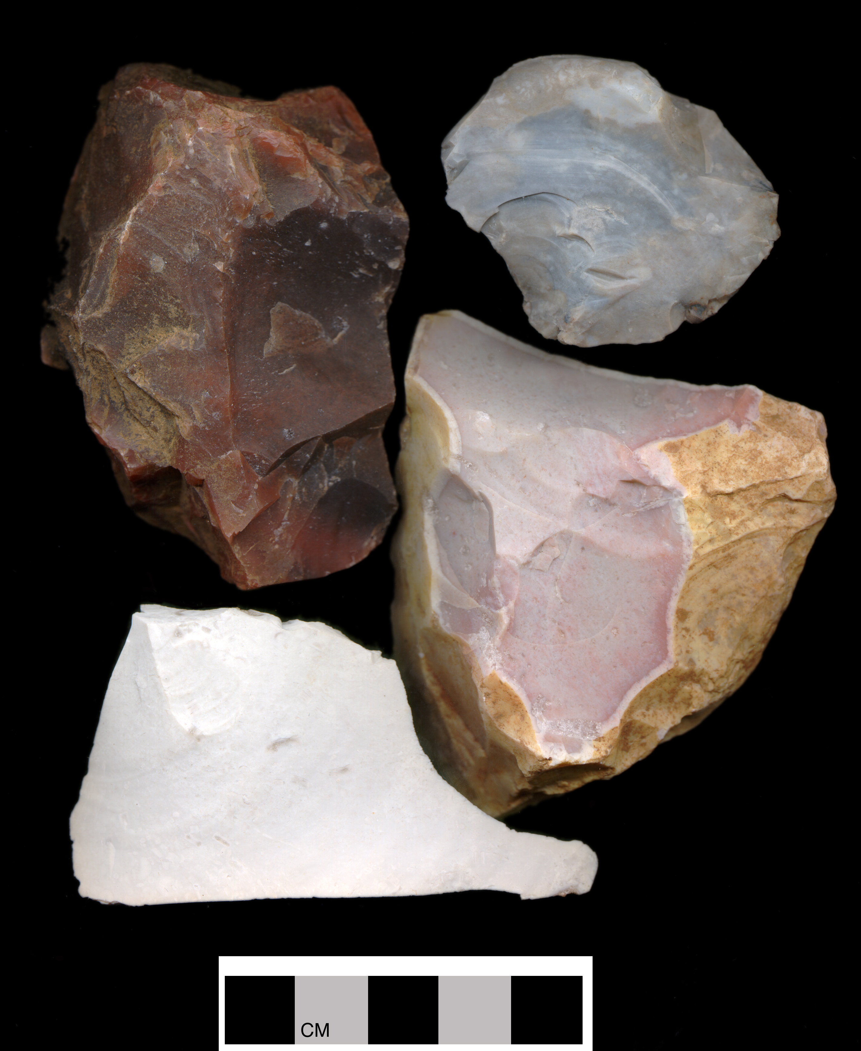
Glacial Till Chert
The glacial deposits of east-central Illinois offer an incredible variety of cherts and other materials rich in silicon dioxide (for instance jasper, chalcedony, and quartzite). The lithic content of our glacial tills may have been plucked up and transported all the way from Labrador, Canada and include elements of all the rock that the glacier encountered in between. Consequently, describing and identifying this source material is very difficult: (1) if an unmodified surface on a chunk or flake of chert (primary or secondary decortication flake) is available, and (2) if that surface is water worn (battered and rounded), and (3) if that surface displays water deposited iron oxide coatings (limonite), then, in our area, it is safe to conclude that the source was a glacial deposit . All of the other chert types in our Guide likely entered the region in a reduced form (1, 2, 3) owing to the demands of manual transportation. One would not wish to pack rock material that one was only going to discard later. Indeed in employing these three sorting criteria, Duggan's (2003) examination of 572 flakes and other debitage recovered from seven sites in the upper Kaskaskia drainage and the upper Sangamon drainage, only 6.5% were assignable to sources other than glacial till. The vast majority of stone tool production that was occurring in the region exploited glacial cobbles (see the discussion below on the special problems of Burlington and Elwood-Joliet Cherts). Consequently, if an object does not convincingly fit the characteristics of one of our other described types, then we think that it should be classified as Glacial Till Chert. While in some sense our category of "Glacial Till Chert" becomes a catchall category for materials that cannot be assigned to one of our other chert types, we have identified all of the major chert types known to occur within a radius of 200 miles of Champaign, Illinois (all major chert types from Illinois, southern Wisconsin, and western half of Indiana). We believe that the presence of lithic material on sites in east-central Illinois from outside of this expansive lithic landscape is extremely rare and unlikely.
Unfortunately, bifacial reduction commonly removes the definitive characteristics of a glacial cobble so that the correct assignment of "arrowheads" to this type category is rendered somewhat problematic. With the realization that 94.5 percent of the debitage from these rather non-purposefully selected sites was of glacial cherts, we were encouraged to see how a sort of bifaces into the different chert categories might proceed if we employed the notion that if the chert was not assignable to one of the categories, then we could assign it to Glacial Chert. Curiously enough, an examination of fifty-one bifaces spanning late Paleo-Indian through Historic Traditions and including all stages of the bifacial trajectory from preform to exhausted, 31.4 % were assignable to categories other than Glacial Chert. By including the preforms, seven of which were Burlington, we perhaps have a more accurate indication of the true extent of local resource exploitation.
Having said this, we must also note that the clear majority of glacial deposit cherts, at least from our recovery area, have the following attributes. Unfortunately these attributes have considerable overlap with both Burlington and Elwood-Joliet Cherts. Correct assignment of small items of debitage to these types must remain somewhat problematic.Little study has been given to how extensively the Stone Age people of east-central Illinois exploited glacial till cherts or what strategies they might have employed in its extraction. If the assignment of lithic resource type is under the best of circumstances somewhat problematic (Vehik 1985: 265; Meyers 1970: 12), dealing with the tremendous variational potential of this chert source has seemed a rather overwhelming task (cf. Roper 1978: 9-11). For instance, even Noel Justice (1987), in his classic work on hafted bifaces from the mid-west, fails to isolate and report this resource. More over, there are here on the till plains no lithic workshops proximate to specific, identifiable extraction sites (i.e., outcrops). Consequently, the answers to such questions have been difficult to generate. In light of our current regional knowledge of prehistoric chert utilization, perhaps we can now offer some exploratory observations on the scale of prehistoric utilization and potential processes of extraction.
Our goals will be to:| (1) | Provide quantitative data on the magnitude of glacial till exploitation; |
| (2) | Provide some insights into natural contexts that might have rendered the extraction of this lithic resource economically viable. |
A. Glacial Till Chert Exploitation: In an attempt to assess the magnitude of pre-historic exploitation, Duggan (2003) examined the debitage recovered from seven sites in the upper Kaskaskia drainage and the upper Sangamon drainage (Tables 1 through 4). Of the total sample of 572 items, only 37 were assignable to types other than glacial deposits (Table 5).
| Table 1: Debitage from the Oak Creek Site, Mahomet Township, Champaign County, Illinois, by chert type. | ||
| CHERT TYPE | FREQUENCY | PERCENTAGE |
| Glacial Till Chert | 31 | 81.58 |
| Non-Till Chert | 7 | 18.42 |
| Total | 38 | 100.0 |
| Table 2: Debitage from four sites in the Upper Kaskaskia Drainage by chert type. | ||
| CHERT TYPE | FREQUENCY | PERCENTAGE |
| Glacial Till Chert | 108 | 85.71 |
| Non-Till Chert | 18 | 14.29 |
| Total | 126 | 100.0 |
| Table 3: Debitage from the Arbuckle 1 Site, Mahomet Township, Champaign County, Illinois, by chert type. | ||
| CHERT TYPE | FREQUENCY | PERCENTAGE |
| Glacial Till Chert | 351 | 97.23 |
| Non-Till Chert | 10 | 2.77 |
| Total | 361 | 100.0 |
| Table 4: Debitage from the Arbuckle 2 Site, Mahomet Township, Champaign County, Illinois, by chert type. | ||
| CHERT TYPE | FREQUENCY | PERCENTAGE |
| Glacial Till Chert | 45 | 95.74 |
| Non-Till Chert | 2 | 4.26 |
| Total | 47 | 100.0 |
| Table 5: Debitage from the seven sites combined by chert type. | ||
| CHERT TYPE | FREQUENCY | PERCENTAGE |
| Glacial Till Chert | 535 | 93.53 |
| Non-Till Chert | 37 | 6.47 |
| Total | 572 | 100.0 |
Indeed, he concludes that the scale of exploitation can best be determined, in a positive sense, by looking at the debitage. His finding that 93.5 percent of the chert was from the till was startling, even if, as he acknowledges, there is some over estimation of frequency given the continued difficulty of distinguishing it from either Burlington or Joliet Cherts. Important also was Duggan's observation that the other chert types (6.5 percent of the total) from more distant locales were represented only by thinning flakes, sharpening flakes, or shatter. Clearly, prehistoric peoples were extensively exploiting the local lithic resource.
Mostly complete or complete bifacial reduction removes the few attributes that makes firm assignment to the till category possible. Approaching the issue from the direction of objects situated within a bifacial reduction trajectory, and appreciating that it is basically negative evidence, Stelle examined fifty-one bifaces from the Parkland College type collection. The collection comes primarily from Goose Creek Township, Piatt County, Illinois. Only 31.4 percent were assignable to one of our defined categories, while 68.6 percent could, and likely did, come from glacial till (Table 6).
| Table 6: Distribution of bifaces from the Parkland College Type Collection by chert type. | ||
| CHERT TYPE | FREQUENCY | PERCENTAGE |
| Glacial Till Chert | 35 | 68.60 |
| Burlington | 7 | 13.70 |
| Wyandotte | 3 | 5.90 |
| St. Louis | 2 | 3.90 |
| Oneota | 2 | 3.90 |
| Moline | 1 | 2.00 |
| Platteville-Galena | 1 | 2.00 |
| Total | 51 | 100.00 |
In summary, and clearly limited by the size of our data sets as well as the lingering vagaries of chert classification, we offer that chert recovered from glacial till was being heavily exploited by Stone Age peoples. One could add that not only was local chert being extensively used in flake tool production but that the till was the source of the lithic material being modified by the technique of pecking and abrading in the production of celts, axes, atlatl weights, etc.; hammer stones; mortars and pestles; hearth stones; and other tools and items of non-chert material.
B. Potential Methods of Extraction: Ground cover, regardless of whether it was the tundra sedges at 14,000 BP, the oak leaf litter at 10,000 BP, or prairie grasses at 8,000 BP (Stelle 1993: 11-12), would have precluded access to the vast majority of glacial till chert. Indeed, in addressing this circumstance prior to the arrival of the grass communities during the climactic hypsithermal at 8,300 BP, the primary source of lithic material would have been associated with fluvial aggradation and bar formation. Subsequent to the arrival of the prairie communities, dependent as they were on fire in their maintenance and expansion, prairie fire would have exposed vast tracks of land surface to lithic extraction. We would like to offer some observations and thoughts regarding the lithic potential of these two natural contexts.
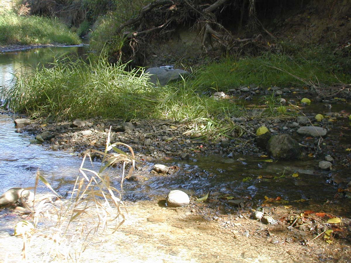
1. Fluvial Aggradation and Bar Formation: On the very low relief land surfaces of the region erosional expressions of significance would center on stream and river channels. It is in these contexts that measurable exposure and, importantly, concentration would occur.
Our recovery technique involved securing 21,284 pounds (4662.9 kg) of 2.5 inch (6.35 cm) or larger gravel from a sand pit located a mile and one-half southwest of Mahomet, Illinois (upper Sangamon drainage). We spread the material over an 800 ft2 area at a depth of four to five inches. From this array was recovered 216 pounds (98.1 kg) of cobbles rich in silicon dioxide, or roughly enough rock to fill four five gallon buckets. The recovered material was of highly variable suitability for knapping. The only two variables controlled for in this approach was minimal SiO2 content and size.
The 800 ft2 value was selected in part because that was the area required to provide the visibility of individual objects necessary for our sorting activity, but also because it seemed a likely areal approximation (20 ft X 40 ft) of a typical river sandbar (Author's Note: 800 ft2 was also the size of the landscaping project that my wife had assigned to me). Based on surveys of streams and rivers in the region, we estimate that, for instance, the trench of the Sangamon River will display five to nine gravel bars of this size per mile. While access to these bars would be a function of water level and while objects of this size would be uncommon, the flow of water would concentrate their presence on the bar's surface. Our final estimation is that there would be something on the order of 31 pounds (14.1 kg) of suitably sized source material available per mile of river. Miller (1973:1) gauges the main valley of the Sangamon River to be 195 miles in length. A rough estimation of the amount of suitably sized cherty material in the main valley alone is therefore 6,045 pounds (2,744.4 kg). Feeder streams would of course greatly increase this value and floods would renew the exposed bar surfaces. The situation with the Sangamon River is considered typical of the other rivers of the region.
While the ratio of cobble sized material to pebble or smaller sized elements is considered to be extremely low (Charles Odle, proprietor of Urban Sand and Gravel, Inc. 1986: personal communication), stream flow would have the salubrious effect of concentrating the larger objects on the bar's surface. One result of this process is that what are actually alluvial deposits composed primarily of sand are popularly referred to as "gravel bars." The circumstance of concentration would greatly enhance the efficiency with which the resource could be extracted.
In conclusion, I would offer a couple of speculations. Throughout human prehistory the streams and rivers of the Prairie Peninsula were a physiographic context of some significance for humans traversing and exploiting the region. In earliest times they may have primarily functioned as impediments to travel. Where to cross the river may have been the primary consideration. During the dry season or winter, perhaps a consideration of little significance. During warmer and wetter times, finding a stream crossing may have been more problematic. Anyone that has ever forded a stream knows that a gravel bottom is convenient, if not necessary, under these circumstances. Importantly however, the visibility of the chert would have been minimal. One would predict low levels of recovery and exploitation. Changes in patterns of cultural adaptation that involved: (1) new subsistence strategies emphasizing riverine resources (e.g., deer, fish, migratory water fowl, shell fish, and amphibians); (2) technological innovations necessitating the use of varying or new lithic resources (e.g., the lithic material required for mortars and axes); or (3) employing the waterways for travel (e.g., water borne transport) would have spawned an entirely different human relationship to rivers and streams. Rather than an impediment to life, the streams and rivers now become the avenue to life. Try to envision the following speculative scenario: A small band of three family units are traveling by dugout up the Sangamon River in 2312 BP. They play a family game testing who has the sharpest eyes, who has the best concentration....who can spot the chunk of chert first. The adults learned the game when they themselves were children. The game helps break up the monotony of what might otherwise be a rather long, confining day, especially for the children. The result was that large quantities of reasonably good chert were readily and pleasantly recovered.
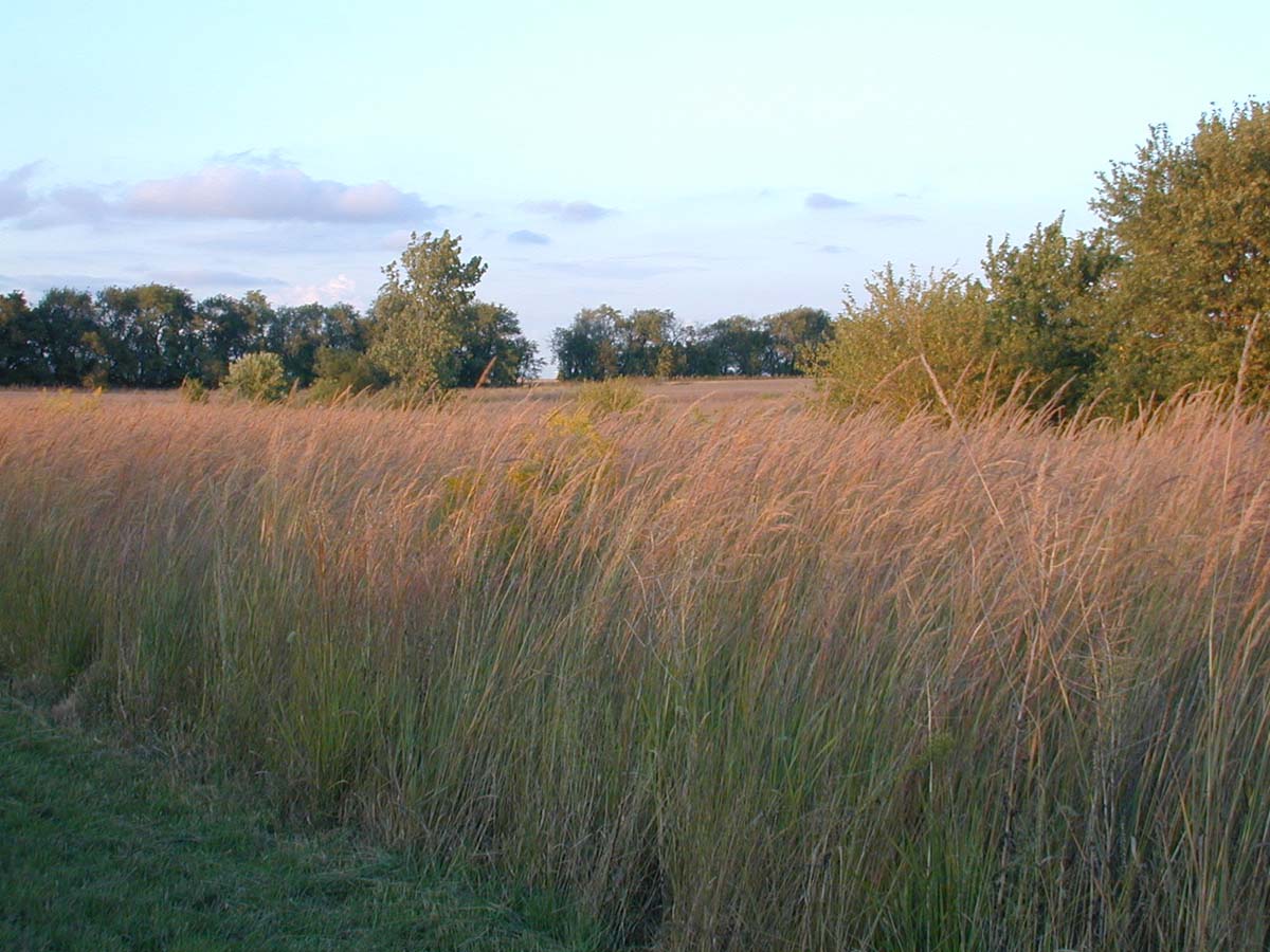
2. Fire: Our impression, however, is that it is the second of the two natural processes, fire, that had the greatest potential of exposing the land surface and opening it up to efficient lithic extraction. An examination of the dominant types of plant communities of primary succession subsequent to the region's de-glaciation may be instructive. Tundra rarely burns and when it does the land surface is even more rarely exposed. For instance, a four to eight inch thick carpet of arctic heather, the tea boiling material of the Great White North, situated on permafrost, typically will not burn to the land's surface. Randi Jandt, Fire Ecologist with the Alaska Fire Service (2003: personal communication), indicates that even the most intense burns will only expose 10 to 15 percent of the mineral soil surface. Forests, of course, do burn, but the burn scars provide limited visibility of the land surface. Partially burned stumps and trunks continue to impede surface collection. We feel that it was not until the arrival of the prairie and the associated occurrence of prairie fire that the potential of clearing large tracts of land of the vegetational mat and making possible collecting transects of fifty or more feet in width became a viable technique for lithic extraction.
In addressing the issue of how much lithic material might be exposed by a burn, we conducted a burn of a restored (five years in to the restoration process), tall grass prairie in Newcomb Township, Champaign County. The particular strip was approximately one-half mile long and seventy-five to 100 feet wide. Subsequent to the burn, the distances between the clumps of the plants (tall grasses being typically clump grass) provided 80% to 85% ground visibility. An issue that we are unable to address at this time is the density of plant clumps in a climax tall grass community, although it is also the case that the root systems of clump grasses can "push" shallowly buried lithic material to the surface. Clearly however, glacial erratics and perhaps even cobble sized objects would have some exposure in the brief weeks following a spring prairie burn. A fall or winter burn would provide an even longer exposure.
A cursory inspection of the denuded soil revealed a perceptible quantity of lithic material. With no particular selective criterion in mind other than angle of the sun for reason of photography, we plotted three areas twenty meters square: Area 1, Area 2, and Area 3. Fifty-four cobble sized or larger specimens were identified, two of which were chert. Clearly, significant amounts of lithic material could be exposed by fire, at least on this landscape.
Evaluating the availability of lithic material by another strategy, we effected a pedestrian transect of the half mile strip. One transect, traveling at a moderate hiking pace, produced eight chunks of chert, cobble sized and larger. The eight objects had a total mass of 7.9 lbs (3.59 kg). Measurable quantities of chert were clearly made available by the natural phenomenon of prairie fire.
Our concern however was the degree to which this landscape was atypical of the till plains of east-central Illinois. The burned grass stand borders what would have been an intermittent prairie stream (the Government Land Office survey fails to record it, albeit the section lines were plotted late in the dry month of August [Rector 1823: 38]). Consequently there is a weakly defined valley and there are some associated ice-contact features. Certainly in this place more erosion has occurred than, say for instance, below the toe of the Champaign Moraine and its associated out-wash plain. Indeed, the prairie strip we burned had been established because the field fell into the formal category of the USDA's Farm Service Agency's, Highly Erodible Land (HEL) and was therefore eligible for inclusion in the federal government's Conservation Reserve Program. The casual definition of HEL is that soil types are included that have a potential rate of erosion greater than the potential rate of replacement. Dr. Sharel Walker (2003: personal communication), agronomist with the Champaign County Soil and Water Conservation District, calculates that at the time of the GLO survey there would have been 34,320 acres or 53.6 square miles of HEL in Champaign County. Champaign County has an area of approximately 1,000 square miles (Mount 1982: 1), resulting in 5.4 percent of the total land surface being classified as HEL. Importantly, the HEL soils are localized to creek and river associations, as well as, terminal and recessional moraines, all of which are physiographic features functioning to concentrate an other wise extremely diffuse lithic resource. Most important, however, is the fact that in Champaign County there was almost 54 square miles of land surface displaying the same potential lithic abundance as our sample tract. Generalizing from our experience, Champaign County alone would have had a potential 48,441.5 pounds (21,992.5 kg) of chert exposed on the land's surface and available for easy extraction.
Based on the preceding observations, I will conclude with another speculative scenario. If in the spring of 6,563 BP you followed a prairie burn scar along the crest of the Champaign Moraine from present day Mahomet to Champaign, a distance of ten miles and a time expenditure of three hours, you would have encountered and been able to pick up 160 cobbles (or larger) of chert. A pleasant way to spend a spring morning. If you returned in the afternoon by a parallel path 200 feet on either side of the original, another 160 cobbles would have been available. A pleasant spring hike, six hours of labor expended, 320 pieces of chert to choose from because the 150 to 175 pounds of total weight would be far too heavy to comfortably carry. Not a bad day's work. Bring your sons and again evoke the family game of who has the keenest eyes, who has the best attention....who can spot the chunk of chert first, and you have engaged in what twenty-first century Americans refer to as "quality family time."
III. CONCLUSIONS:
Koldehoff (1999) argues that the rather heavy exploitation of Attica Chert by people of the Paleo-Indian Tradition was because of the scarcity of chert on the till plains of central Illinois. While we have no problem accepting his observations regarding the heavy exploitation of Attica Chert by the people occupying the Anderson and Perkins Sites, or even more broadly, the use of distant or "exotic" cherts by Paleo-Tradition people that has been observed by other researchers, we do take exception to Koldehoff's rationale. In contrast, we would argue that the issue was not one of resource existence, but one rather of cultural form and environmental constraint. We feel that we have been able to demonstrate that subsequent traditions exploited the regional lithic resources to an overwhelming extent relative to the cherts extracted from more distant locales. What was required was a cultural adaptation focusing more centrally on the streams and rivers of the region and the arrival of the prairie community at 8,300 BP. The convergence of these two conditions lead to a geometrically enhanced efficiency in the indigenous lithic extraction strategy.
As a final thought, we would add that other forms of lithic material were also being recovered by prehistoric people. Specifically we think in terms of the igneous rock used in pecked and abraded technology, heating stones, hammer stones, mortars and manos, and the igneous and metamorphic forms used in the production of grit temper. All of this material would have only been found in till contexts. As a consequence, for the archaeological traditions that were to follow the Paleo-Indian, glacial till became an extremely important lithic source.