Keywords: Meskwaki Indians, Fox Fort, Fox indians, Renard, Inoca, Illinois Indians, Illini, midwestern archaeology, Illinois archaeology, Sangamon, Seige of the Foxes, Ft. St. Joseph, Ft. de Chartres, St. Ange, Simon Reaume, de Villiers, Jean-Baptiste Reaume, Chaussegros de Lery, Hocquart, John H. Burnham, William Brigham, Jacob Smith, Wayne Smith, Vicki Smith, McLean County history, Parkland College history,
Introduction
In 1986 my Parkland College archaeology students and I began our investigations of a locale recorded as 11ML6 in the site files of the Illinois Archaeological Survey. The site form had been completed in 1947 by John McGregor (then at the University of Illinois) and he had followed the usage established by Captain John Burnham (1897) in 1897 of the rather romantic appellation "Arrowsmith Battleground." However, to most casual observers the place has been known through the twentieth century simply as the "Fox Fort." Over the years we have attempted to provide regular updates on our activity in a wide variety of venues (lengthy list of citations). Now as a quarter of century of effort draws to a close, I have decided that the Internet is the only medium capable of adequately presenting the very large quantity of both graphical and textual material that we have assembled. Welcome to the home of the 1730 Meskwaki Fortification.
Len Stelle starring in an on-site interview video. "Wild" Mike Colther of Parkland College's Department of Distance and Virtual Education, directed the taping, conducted the interview, ran the camera, and edited the tape. Also appearing in the video are Parkland archaeological field school students: Tonie Sadler, Grant Brewer, Brittani Fisher, Kristin Hess, Alyssa Lee, Jenna Mortensen, Emile Rutherford, Ariel Taylor, Sarah Vannice, and Claudie Walls. Making a cameo appearance is Smith Family member Vicki Smith. Providing the code to bring the video to your monitor was Bob Richardson, Web Application Developer, Department of Distance and Virtual Learning. I extend my gratitude to all of these friends of 11ML6.
And now, on with the show......
TABLE OF CONTENTS
(Click on chapter titles to go to chapter)
During August and September of 1730 the major conflict of the Second Meskwaki War was waged somewhere in east central Illinois. The lack of useful landmarks, conflicting contemporary accounts, and the poverty of eighteenth century cartography have contributed to confusion concerning its exact location. French documentary sources indicate that the battle involved a siege of approximately twenty-three days, 950 Meskwaki, 1400 French and Indian allies, a major victory for the French and a crushing death toll for the Meskwaki. Over the ensuing 135 years the exact location of this singular event was forgotten and lost. However, by at least 1865 historians began to speculate over possible interpretations of distance and direction indicators as well as advance nominations for the specific locale (Ferland 1865:436-439; Steward 1903, 1908; Burnham 1897, 1908; Kellogg 1908; Brigham 1936; Peyser 1980, 1987; Edmunds and Peyser 1993; Stelle 1989, 1992).
As all students of the conquest of North America realize, France and the other European countries would spend hundreds of years and many generations penetrating the continent's interior. From their perspective it was, indeed, "...a vast and uncharted wilderness." Maps of ever greater precision would be a hallmark of the craft. Indeed the pursuit of greater accuracy continues even today. In the generations after the arrival of the French, accuracy would progress in fits and starts. We are including here just two illustrations of what many at the time considered to be notable accomplishments of French cartography. The drawings were produced by Guillaume de L'Isle (Delisle). Delisle was appointed Premier Geographe du Roi (Geographer to the King) in 1718. Most contemporary witnesses would have considered the appointment a singular and crowning achievement.
Carte de la Louisiane et du Cours du Mississipi (Figure I.A.1a) was published in the year of Delisle's instalation as Premier Geographe du Roi(1718). For students of the history of Illinois, it is in some ways a disappointment. For instance, there is a non-existent copper mine shown on the Salt Creek (north fork) of the Sangamon River (here labeled Ouramam or R. aux Pommes [River of the Apples]); a stretch of the modern Illinois River is labeled R de Macopin; the Vermillion River of the Illinois is either missing or moved far upstream of le Rocher (modern Starved Rock); and second, third, and fourth order rivers are represented by the technique of a scriggly line extending in a general direction. In other ways the drawing is very exciting, e.g. it is the first widely available document to include in the region of Illinois three of the four major tributary rivers flowing to the east and south banks of the Illinois River. A major, large-scale concern is that Illinois is greatly stretched and distorted east to west with the Illinois and Wabash Rivers tending more northeast to southwest. The symbol of hills or mountains lying between the two rivers, a physiographic region today characterized as a vast till-plain, could perhaps correspond to the topographic fact that the Bloomington Morainic System, within which ML6 is located, is the highest point and boldest relief between Chicago and St. Louis. For 1730 observers, de Lery for example, to state that the fortification was situated between the two rivers some 50 leagues (120 miles) east-southeast of le Rocher on a small river near the Macoupin seems a not unreasonable approximation. Indeed, in Franquelin's 1684 Carte de la Louisiane or the Voyages of LaSalle, Macoupin is an alternative name for the River of the Illinois.
Carte du Canada ou de la Nouvelle France (Figure I.A.1b) is dated 1730. The drawing, alas, is missing the modern Macoupin Creek, the great fork of the Sangamon River, le Rocher, and the hill symbols found on the 1718 map. All river channels continue to be as much symbolic as representational.
a
b
Figure I.A.1. (a) Carte de la Louisiane et du Cours du Mississipi. (b) Carte du Canada ou de la Nouvelle France. Click on images for larger views.
To illustrate the problem of early eighteenth century French cartography, I am including two maps of the Illinois country by the French Royal Geographer. Guillaume de L'Isle (Delisle) (1675-1726) was the most important French cartographer of the early eighteenth century. He was noted for his prolific production (over 100 maps) and exceptional accuracy. He was appointed Premier Geographe du Roi in 1718.
The point of this exercise is that by contemporary cartographic standards the border regions of New France and Louisiana, particularly as one moved away from the corridor rivers of transport, were but very poorly documented and understood even by 1730. And so how are we to re-establish the location of the fortification? At least ten tracts are offered in the literature as the site of
the fort [see Peyser (1980:208) for a summary discussion]. Authors have chosen
their locations on the basis of their perceptions of the veracity of the
historical documents and their interpretation of distance and direction
measurements. All of the distance and direction references are generalized and
presumably reflect surface rather than statute distances. This ambiguity has
left much room for historical speculation.
Of the three narratives, only the Reaume Narrative (Appendix D) provides a
distance and direction reference (Stelle 1992:268). The other two are surprisingly silent with
regard to this central consideration. Reaume indicates that the Meskwaki were found
"...50 leagues southeast of Le Rocher."
The three statements that researchers had relied upon prior to our recovery of the Reaume Narrative are: (1) the
legend of de Lery's Blocus du Fort and Plan du Fort des Sauvages; (2) a letter from Hocquart to
the French Minister of Marine, dated 15 January 1731; and (3) a detail in the
map Sauvages Renards Attaques. De Lery indicates that the
fort was located 50 leagues east southeast of Le Rocher. Hocquart's report
states "...in a plain situated between the River Wabache and the River of the
Illinois, about 60 leagues to the south of the extremity or foot of Lake
Michigan, to the east-south-east of le Rocher in the Illinois Country"
(Thwaites 1906:129). Lastly, the detail on the Sauvages Renards Attaques chart indicates that the fort was located on the River of the
Renards or the Beiseipe River which flowed into the Mabichi River. The
Mabichi, in turn, emptied into the Greater Wabash. The detail further adds
that this river system extended to within 40 leagues of le Rocher and was
located to the southeast. It is extremely important to note that in spite of much bluster in the historical community, all distance and direction values were based upon the determinations of Lt. de Villiers which were reported by Lt. de Villiers son, Coulon, and Jean-Baptiste Reaume. I doubt that Lt. de Villiers knew how to use an astrolabe or bothered to take one along on the expedition and Jean-Baptiste Reaume was illiterate. In any event, de Villiers concluded that the fortification was 50 leagues south and east of le Rocher.
Please indulge a brief speculation with regard to linear measurements. Firstly, I am currently examining a map of France produced by Delisle and dated April 1721. The scalar unit is the league. On this drawing Delisle includes nine different scales corresponding to nine different types of league. In the French cartography of 1721, as presented on this drawing by the Royal Geographer of France, a league could be as little as 10,880 English feet (Lieues de Beauce et de Gatinois) or as much as 19,200 English feet(Lieues de Gascogne et de Provence). So when de Villiers or Reaume states that the fort is 50 leagues distant from le Rocher, we have no way of judging which type of league he was referencing 50x10,880=544,000/5,280=103 English statue miles or 50x19,200=960,000/5,280=182 English statue miles.
Secondly and in spite of the complexities of answering the question of what was the distance of a French league in 1730, I have always wondered how any distance measurements were made in the absence of an instrument like an astrolabe. This said, we should point out that the standard definition of the league as a unit of linear measurement, extending back to Roman times, was that it was the distance a man (or horse) could walk in one hour. Applying this concept, perhaps what is actually being referenced is that the fort was a 40 to 50 hour walk from le Rocher. Of course, there is also the issue that there were no clocks.
De Villiers, St. Ange and the others associated with the 1730 Meskwaki siege knew that the Meskwaki fortification was between the rivers Illinois and Wabash, three or four days of hard overland travel south and east of le Rocher, but they really could be no more precise. As we shall see later when we discuss the various charts of the fortification, it is not clear that any one among the French forces possessed a compass or knew how to use it, let alone an astrolabe. What seems consistent about these four descriptions is a location southeast or
east southeast of le Rocher some 40 to 50 hours of trail-time in a then unmapped region of
Illinois. With river systems uncharted at the time and river names
unrecognizable today, these referents are of little direct use. Even if one
could be certain of the drainage, pinpointing the fort would remain difficult.
Obviously, we have an ambiguous situation.
As indicated earlier, several sites have already been presented as possible
locations using historical argument and speculation. Having reached the likely
limits of this epistemological technique we reassert our earlier contention:
which, if any, is the actual site is an empirical question, answerable through
archaeology.
While several documents which make reference to the siege are
available in the published literature, only two may be properly considered
primary accounts (Thwaites 1906:109-118). One is the official report filed by
Lieutenant Nicolas-Antoine Coulon de Villiers, Commandant at the River St.
Joseph and commander of the French forces (see Appendix A). The other is an unattributed
narrative authored by a Fort de Chartres source under the direction of
Lieutenant Robert Groston de St. Ange(see Appendix B) . De Villiers' account is dated 23
September 1730. It was carried to Quebec by his son, Louis Coulon de Villiers,
and the interpreter, Jean-Baptiste Reaume. They delivered it to Charles de La
Boische de Beauharnois, Governor of New France. The Ft. de Chartres version is
dated 9 September 1730 and was issued in New Orleans.
In the spring of 1989 a third narrative of the battle (see Appendix D) was identified in the
Archives Nationales in Paris, France. The existence of the document had been
suggested in a letter to the Minister of Marine from Gilles Hocquart, Intendant
of New France (see Appendix C). It is dated 14 November 1730 (Thwaites 1906:119-120). In the
missive, Hocquart indicates an "annexed relation" of the siege based upon his
interview of Jean-Baptiste Reaume, de Villiers' interpreter. Hocquart even
allows that he had "...retained the expressions of the Sieur Reaume which are
according to Canadian usage." (Thwaites 1906:120). Hocquart's suggestion that
it "...contains some details omitted by Monsieur Devilliers." is accurate from
the perspectives of both history and archaeology.
The document is dated 7 November 1730 and was issued from Quebec. It thus
precedes Hocquart's letter by a week. From the first paragraph it is apparent
that the informant and central character in the narrative is Jean-Baptiste
Reaume, "...interpreter for the sauvages that dwell along the River St.
Joseph." The account was transcribed by D'Auteuil de Monceaux. The document
had been filed under a misspelling of his name. Auteuil, in a 1722 letter from
Vaudreuil, then Governor of New France, is accused of being an immoral consort to
the marriage of Jean-Baptiste Reaume's brother, Simon (Peyser 1982:62). Both
Jean-Baptiste and Simon play major roles in the account.
The three accounts agree in general chronology, offer useful detail on the natural setting of the site and the architecture of the fortification, and the strategy and internal politics of the allied forces. In the spring of 1730, many members of the Meskwaki Nation determined to abandon their homeland in central Wisconsin and relocate with the Iroquois (New York). By late June the great exodus had begun - baby and elder, male and female, firm and infirm. De Villiers' informants advised him of this movement and he set out with a mixed party of 350 men. After 100 leagues of wandering in the wilderness, he abandoned his search and retired to St. Joseph. Seizing on this opportunity to advance, the Meskwaki halted briefly at le Rocher to seek permission from the Cahokias to cross their territory. The councils did not go well, a Meskwaki envoy was insulted. In response, the Meskwaki captured several Cahokias and burned the son of a Cahokia chief. Angered, the Cahokias sent runners to Ft. de Chartres, Ft. St. Joseph, and the Miami Post seeking support for a general call to arms. The Cahokias (Illinois of le Rocher) pursued the Meskwaki. The exodus detoured far south of Lake Michigan to avoid a strong French and Allied presence positioned to block their advance. With this detour, the Meskwaki hoped to gain permission for peaceful passage through the lands of the Ouiatanons (west-central Indiana) to whom they had sent colliers de porcelain and calumets.
Upon contact, the Illinois of le Rocher engaged the Meskwaki who, in turn, took possession of a small grove of trees and therein fortified themselves (unlike the fort which they had abandoned and which protected their Grand Village on the River of the Renard's in Wisconsin, here the Mesquakie were forced to simply "fortify" a grove of trees, that is, an expedient fortification consisting of timber and earth, exploiting all natural cover and working mostly at night under the protection of darkness). The next day runners were again sent to the Miami post and to the St. Joseph command to report the fortification's location and direct their support. The Ft. de Chartres account indicates that the allied Indian forces had been awaiting aid for a month prior to the arrival of the French.
By 10 August St. Ange was moving north with 500 men and de Villiers southwest
with 300. They joined with the 200 already present at the site. Another group
of 400 Ouiatanons and Peanguichias under the command of Simon Reaume arrived the same day as de Villiers, bringing the total to about
1,400 men at arms. St. Ange was the first to arrive (17 August) with the rest
of the forces arriving shortly after 20 August.
According to the Ft. de Chartres narrative the Meskwaki fort was in:
... a small grove of trees surrounded by a palisade situated on a
gentle slope rising on the west and north west side on the bank of a small
river, in such manner that on the east and south east sides they were exposed
to our fire. Their cabins were very small and excavated in the earth like the
burrows of the foxes from which they take their name (Thwaites 1906:111).
For his part de Villiers offers the following description of the enemy's
position:
The Renards' fort was in a small grove of trees, on the bank of a little river
running through a vast prairie, more than four leagues in circumference,
without a tree, except two groves about 60 arpents from one another (Thwaites
1906:115).
He also adds that the Meskwaki had ditches on the outside of their fort.
The Reaume account adds little to the description of the natural environment,
suggesting only a woods located in a "... prairie as far as the eye could see."
However, it provides some interesting detail on the fortification:
The Renards fortified themselves in their woods and the allies in the prairie a
half a league from each other. The Renard fort was of stakes a foot apart,
crossed at the top, all joined together and filled in with earth between them
as high up as the crossing. On the outside a ditch ran around three sides with
branches planted to hide it, with pathways of communication for the fort in the
ditches and others that ran to the river. Their cabins were complete with
joists covered with decking, commonly called straw mats (natter de
paille). On top of this there was two to three feet of earth, depending on
the cabin. There were covered ways such that one could see only an earthwork
(terrasse) that would cast a shadow in the fort (Appendix D: Reaume Narrative).
The main encampment of St. Ange was to the south of the river. This group
positioned three redoubts and attendant trenches so as to command the river and
deny the Meskwaki access to water. De Villiers' primary encampment was to the
northeast or north of the Meskwaki fort. His forces constructed two cavaliers (gun towers, firing platforms) on the high ground overlooking the fort, as well as an attack trench from which
he hoped to set fire to the fort.
During the ensuing siege the allied forces were plagued with internal
intrigues, shifting sympathies, and intertribal conflicts. The French alliance
was a fragile one. On 1 September Nicolas des Noyelles arrived with 100 men
from the Miami post. On 7 September, 200 of the Illinois, having been engaged for over two months, departed for home.
On the eighth of September an intense, late summer storm blew up an hour before sunset and as the Ft. de Chartres
narrative records "...interrupted our work" (Thwaites 1906:113). The night was
rainy, foggy, and very cold. The allied Nations refused to man their posts.
Seizing this opportunity, the Meskwaki escaped from their fortification. Both the charts from de Lery (Blocus du Fort and Plan du Fort des Sauvages respectively) and New Orleans (Carte du Fort) show the Meskwaki exiting in three groups and along three different paths (curiously, none of the narratives make reference to this circumstance, please see our discussion on Table 3. Item 21.) .
However, the
crying of the children alerted the French sentries and their flight was
discovered. Fearful that in a night engagement their own allies would fire
upon them, the French command determined to wait until daybreak before
launching their assault. At dawn, some eight leagues from the fort, they rushed the exposed Meskwaki. "The women, children, and Old men walked at the head, and the Warriors posted Themselves in the rear to Protect them. Their ranks were at once Broken and defeated." (Appendix C: St. Ange's Narrative). The Reaume account further states that 500 were killed
and 300 captured and that forty of the captured warriors were "burned." Additionally, the
Ft. de Chartres narrative states that not more than 50 or 60 unarmed men escaped and de Villiers adds that one of those that escaped was the "chief," Licaouais.
The siege was ended. The Meskwaki were seemingly crushed. The French proclaimed their victory with vigor.
While it is the case that the ten maps we are about to present have not all appeared in the literature, de Lery's were first introduced by Steward (1908) and Carte du Fort, Fort des Renards, and Sauvages Renards Attaques by Peyser (1980, 1987). Both scholars seem to evidence either errors of interpretation or important omissions. Consequently, we have decided to simply provide our own interpretations. Our first challenge was to decipher the handwriting of those that created the various maps and the second was to offer a culturally and temporally sensitive elucidation of the French employed on the frontiers of New France and Louisiana. Furthermore, insofar as we were examining military fortifications illustrated by individuals thought to have had at least some training or experience in the drafting of military engineering, we have also relied on the U. S. National Park Service's glossary of terms for military earthworks (among other sources) for recognition of military linguistic conventions, for example, fosse, palisade, and covered ways. Owing to the complexity of this task, our interpretations sometimes include in brackets information thought useful to clarification or understanding. As always, we invite comment.
The great blessing, as well as the great curse, in the search for the Meskwaki fortification has been the number of maps known to survive. We have identified four distinct illustrations of the battle camp, as well as a plan view of the fort with a number of appended details. As we will present momentarily, three of these drawings involve multiple iterations, all done by hand and by a variety of draftsmen so that each is at least slightly different from all others. But these are variations of the craft and handwork. The variation that has been so odd and so frustrating is that of the basic geometry of the fortification. I have long subscribed to the value of historical triangulation and such does not apply here.
The official map of the battle camp (Figure 2) and the plan of the fort with the appended details (Figure 3) are signed by Chaussegros de Lery (respectively titled Blocus du Fort and Plan du Fort des Sauvages). De Lery was the chief military engineer of New France and as such had responsibility for the official documents. De Lery's informants were de Villiers' son, Coulon, and the interpreter, Jean-Baptiste Reaume. These interviews occurred in Quebec when the two reported de Villiers' victory. The two sets of documents are dated 10 and 15 November 1730.
Figure 2. Blocus du Fort. Click on images for larger views.
Table 1. Translations of the information displayed on Blocus du Fort.
1. Blocus du Fort des Sauvages Renards, par les Francois et Sauvages, scitue entre les Rivieres des Islinois et celle d'ouabache, a 50 lieues a L'Est-Sud-Est du Rocher, dans la Nouvelle france. Dans les mois d'aoust et Septembre 1730 [Of the four drawings, this last sentence only appears in the 10 Nov drawing of the Blocus.]
Translation: Blockade of the Fort of the Fox Indians, by the French and Indians, [situe] located between the Rivers of the Illinois and the one the Wabash, at 50 leagues to the East-South-East, in the New france. In the months of August and September 1730.
Note: The only difference between this legend and that found on the Plan du Fort is the substitution of the word Blocus for Plan.
2. Camp of Monsieur de Villiers and de Noyelles composed of French, Miamis, Potawatomis, Kickapoo, Mascouten, and Illinois of the Rock in all 800 men
3. Camp of Monsieur St. Ange composed of 100 French, the Illinois, Pinkashaw in all 600 men.
4. Fort des Renards - Fort of the Foxes
5. Contrevallation - A contrevallation involves a defensive earth work constructed to protect the rear of the siege lines (circumvallation) from attack. It is not clear why such would have been necessary in this situation. Perhaps it was simply a descriptive convention employed by De Lery.
6. Text shown in river:
Small river close to the Macopin
7. Sortie ou Fuite des sauvages Renards
Ou ils furent defaits le 9 Septembre 1730.
A une Journee de chemin du fort.
Sally or flight of the Fox Indians
When they were defeated the 9 September 1730.
A one day's trail from the fort
Note: Three paths are shown as is also the case with Carte du Fort.
8. The drawing shows three small, nested squares along the line of the Contrevallation. Perhaps they symbolize strong points in the trench line. Two such symbols are also positioned to the south of the river.
9. West and east are noted along the left and right margins, respectively.
10. There are two additional clusters of the symbols de Lery employs for the "tents" in the two French camps. These two clusters are situated on the north side of the river and are otherwise unlabeled.
11. The word Prairie appears in all four quadrants.
12. There is a grove of trees lying along the south bank of the river and northeast of the camp of St. Ange (Item 3).
13. I am struck by the fact that in both drafts the number and layout of all the "tents" in the French camps remain the same. De Lery rather carefully plotted each "tent." This is also true of the "houses" within the fort. Although many fewer in number, they, too, remain the same in location and frequency on both drawings. Unfortunately, from excavation of the fortification's interior we know that the count and distribution are wrong.
Figure 3. Plan du Fort des Sauvages. Click on images for larger views.
Table 2. Translations of the information displayed on Plan du Fort des Sauvages.
1. Plan du Fort des Sauvages Renards, par les Francois et Sauvages, scitue (situe?) entre les Rivieres des Islinois et celle d'ouabache, a 50 lieues a L'Est-Sud-Est du Rocher, dans la Nouvelle france.
Translation: Plan of the Fort of the Fox Indians, by the French and Indians, located between the Rivers of the Illinois and the one the Wabash, 50 leagues to the East-South-East of the Rock, in New France.
Note: Plan has been substituted for Blocus in the legend of Blocus du Fort, otherwise the two statements are identical. Doing so renders the "by the French and Indians" phrase rather nonsensical. In any event, the Blocus du Fort must have been drafted first and the text just copied over to the new document.
2. Explication
The three sides B C, B D and D E were enclosed with two rows of stakes planted in the earth. The rows, six feet apart were leaning likewise and crossed at the upper ends. The interval formed in the triangular profile was filled with earth which formed a sloping wall on the outside and one inside supported by stakes that they had covered with earth and sod to protect them from fire and there appeared outside only the ends of the stakes above the place where they crossed. All this protective wall was raised around the area to be defended about ten, twelve or fourteen feet in height marked on profile F. Without these three sides there was an adjoining defensive trench marked G of about five or six feet wide and five feet in depth of which the earth served to fill the interval between the stakes forming the enclosure. The Foxes came out of the fort into the defensive trench by small earth covered passages four feet in height marked H, whose entrance into the fort passed under the defensive wall and went to the bottom of the defensive trench to permit shooting over the open, level area outside the fort in such a way that they were not seen.
On the side to the river B E, there were just two rows of stakes because the bluff was steep [and] about fifteen feet high, they had made dirt covered passages [In standard military usage a "covered way" is a ditch and parapet designed to protect and conceal the movement of troops and supplies by providing cover from gunfire (National Park Service: Glossary Military Earthworks Terms)] marked 1, 1, 1, in order to go after water in safety, the passages began in the cellars [dugouts] of the fort and went to the river, they were made like the passages to the defensive trenches.
There is a height marked K which commanded the fort, they made a corridor in the dirt [see reference above to "covered way"] marked L which had its entrance in the fort and the exit went to the top of the height which they had occupied, around which there was a low wall like that of the fort.
In the fort they dug several defensive trenches like the cellars marked on profile M. from 7 and 8 feet in depth and of various shapes and sizes, for the internal communication network, all was covered with pieces of wood, with dirt on top, and above each defensive trench there was a roof with different slopes covered with dirt and sods provided with holes. Their design was to make use of the defensive trench outside to retard the approach [of the French], the low, defensive wall to prevent the entrance to the fort, if they were obliged to shut themselves under the roofs to shoot, and not being able to hold out there, to escape by the earth covered passages which go to the river that is fordable.
3. The wall profile detail:
Mark F:
Stakes planted in the earth crossed at the top and slowly filled with earth and the two sides covered with earth and sod.
Mark H:
Descente sous terre pour aller dans le fosse
Descends underneath the dirt for to go into the defensive trench. [Note: In lieu of excavation,
the precise meaning of this reference remains confusing.]
Mark G:
Fosse
A fosse is a defensive trench or a breastwork. The trench will have the back dirt piled to either or both sides so as to afford a defender a comfortable and secure means of directing fire and of movement.
Esplanade
An esplanade is a relatively large, open, level area outside a fortification. It is intended to provide clear fields of fire for the defenders.
4. The profile detail of the Meskwaki domestic quarters, marked M:
Couvertuve de pieces de bois et couvertes de terres et bazons avec des trous pouv tirer
To provide protection the pieces of wood are covered with earth and sod with the holes for shooting/firing.
Caves ou fosse dans terre couverte avec pieces de bois et de la terre M
Cellars (dugout) or defensive trench into the earth covered with pieces of wood and with the dirt M
5. Text shown in river:
Petite Riviere Proche Celle de Macopin
Small River Near the One of Macopin [with arrow pointing west to east]
Note: Same as on the Blocus although I have here translated it in a more literal fashion.
The Macopin was assigned to different drainages feeding into the Illinois during the eighteenth century. Today it is assigned to the drainage below the Sangamon. On the De Lisle 1718 map, it is shown as a section of the upper Illinois River. On Franquelin's 1684 Carte de la Louisiane it is given as an alternative name for the Illinois River itself.
6. Notes on the three escape paths (there are some grammatical variations in the four drawings):
Sortie et fuite des Sauvages Renards ou ils
Furent defaits le 9 Septembre 1730. A
Une Journee de Chemin du fort.
Exit and flight of the Fox Indians as they
Were undone 9 September 1730.
One day's distance from the fort.
7. West and east are noted along the left and right margins, respectively.
8. The word Prairie appears in three of the four quadrants.
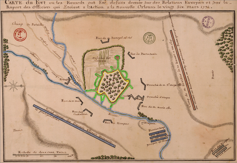
The Ft. de Chartres narrative is associated with four drafts of the same illustration. The drafts vary in minor but perceptible ways. All were apparently produced in New Orleans. They are titled Carte du Fort and are
dated 26 March 1731. The legend indicates that the drawing was based upon military dispatches and the officers'
report. The chart indentified as No. 46c may be the master because it includes a few details omitted in the other three. The script, patterned misspellings, and the techniques of both the north arrow and scale, suggest that a single draftsman produced A, B, and 46c. The rendering identified as 47c corrects the misspellings (e.g. champ becomes camp, Prerie becomes Prairie, and the abbreviation of monsieur is corrected) and displays a more refined script and drawing technique (for instance, the depth of the fosse is indicated by the use of shadow rather than the crude use of curved lines). One curious detail on all four documents is the cleared land to the left of the fortification. We observe a patch work of what could be interpreted as small cultivated areas, all of which is bounded by a symbolic line of natural vegetation (brush?). Only 46c provides a label and even it is rather enigmatic: Defriches des Sauvages. Possible interpretations are "Cleared by Indians" or "Indian cultivation." While the Meskwaki may have arrived on site as early as late July and could therefore have, in desperation, put out a crop, our excavations indicated the presence of the fortified domestic structures in this area.
Another detail common to the four drafts and for which the labeling remains consistent is the element of the escape routes employed by the Meskwaki. Three are shown with one crossing through an attack position labeled tranchee (trench). The label on the escape routes reads Chemin des Sauvages defaits. or the "Path(s) of the defeated Indians." As was the case with the de Lery drawings, the fleeing Meskwaki depart in three groups each following its own route.
Nothing else is known about the production of these documents, although the master may have been generated by a royal engineer of Louisiana. Engineers doing
this type of work at the time include Pierre Baron, Ignace Francois Broutin,
and Francois Saucier (see Saucier and Seineke [1969] and Wilson [1969] for
discussions of their careers and work).
Figure 4. Carte du Fort. Click on images for larger views.
Table 3. Translations of the information displayed on Carte du Fort.
1. Carte du Fort ou les Renards ont ete defaits dressee sur des Relations envoys et sur le raport des Officiers qui etoient a l'action a la nouvelle Orleans le ving six Mars 1731
Translation: Map of the Fort where the Foxes were defeated based on the Dispatches and on the report of the Officers who were in the action drawn up at new Orleans the 26th March 1731
2. Camp de Bataille
Camp of Battle or Battle Camp
3. Area to the left of fort appearing as cultivated fields:
Defriches des Sauvages.
[Defricher] Cleared by Indians or Indian cultivation
Note: This script detail only appears on the No. 46c drawing although the illustration remains on the other three.
4. Details concerning the river:
On the upper two charts there is no label on the drawing of the river. On the two bottom charts the river is just marked Riviere or "small river."
5. There is a symbol of a flag with the word Drapeau proximate to it. Drapeau means "Flag."
6. Fort of Monsieur Marin
Note: With this and item 12, below, we have the only references to Monsieur Marin from anywhere in the primary documents. My feeling is that the St. Ange people noted the presence of the Green Bay group as being that of Marin rather than Simon Reaume. I am thinking that Paul(?) Marin had charge of Green Bay. Of significance is the fact that from the documents of New France (Canada), no commander named Marin was present at the siege. I could but offer speculations regarding the rationale of St. Ange's officers' usage. It could be simple ignorance and lack of overall command communication and control. This interpretation is reinforced when one examines item 15, below. Note the apparent inaccuracy of even a phoentic spelling of De Noyes surname. The misspelling is common to all four drawings.
7. Fort of the Kaskaskias
8. Fort of the Kickapoos
9. First camp the Illinois of seven hundred men to include 150 French
10. Second camp the French Illinois Missouris and Pinkashaws.
11. Camp of Monsieur DeVillier with 20 French with [lui?] him 100 Miami 100 ouyatonon 100 Sauk 100 Potawatomis. Peoria Kickapoos Mascoutin 200
12. Fort of Monsieur Marin Officers
13. Defensive trench of Monsieur St. Ange Officers
14. Fort of the Potawatomis
15. Fort of Monsieur Desnoyel Officers
16. Tranchee
Defensive trench
17. Cavalier
Gun tower
18. Tranchee d'ataque
Attack Trench
19. The word Prerie [Prairie] appears on both the left and right edges of the drawing.
20. Clumps of timber appear along the left, bottom, and right edges.
21. Meskwaki escape routes:
Chemin des Sauvages defaits.
Route of the defeated Indians.
Note: Three separate routes are shown with one passing through the earthwork labeled Tranchee. It may be significant that this single path does not include the word "defeated." On the upper three charts, this path through the Tranchee also has a different color from the other two paths. Chart No. 47c (bottom) uses a different drawing technique for the paths and possibly that is why the paths are all the same color. De Lery's drawings make no such distinction. However, the three routes are common to all eight drawings and are likely significant. Given that the Meskwaki tradition holds that they broke into four groups, I would offer that one group got away undetected, one was detected but got away, and two were detected and attacked the next day by the French forces.
Peyser (1987) has offered an extensive analysis of the two remaining charts.
Given the Reaume account, Fort des Renards and Sauvages Renards
Attaques seem circumstantially associated with it. The references in the
narrative correspond to those of the maps, placing as they do a singular
emphasis on the roles of the Reaume brothers. It should be noted, however,
that while the Hocquart communication makes reference to an appended narrative
it makes no mention of a map. Neither is signed or dated. Consequently, how
these maps found their way to the records of the Minister of Marine remains
open.
Figure 5. Fort Des Renards. Click on images for larger views.
Note the generally more primitive cartographic quality of the drawing to include the absence of a north arrow and scale. The map maker appears to have had some training and skill at illustration, note for example the character of the French tents, the detail of the cavaliers, the technique of the trees, and the embellishment of the lunettes. On the other hand, basic mapping conventions like a scale and direction indicators and the fact that north is to the bottom of the drawing, suggest someone not trained in cartography.
While we feel that it was the model upon which Sauvage Renards Attaques was constructed, the handwriting and styles of illustration are perceptively different.
Table 4. Translations of the information displayed on Fort Des Renards.
1. Fort Des Renards
Fort of the Foxes or Fox Fort
2. From the Key:
A….Camp of Mr. [Monsieur] de Villiers
B….Camp of Mr. [Monsieur] Denoyelles
C….Camp of Mr. [Monsieur] de St. Ange
D….Camp of Mr. [Monsieur] Simon Reaume
E…. Trenches opened (ouvert) by the Srs. [Seuirs] Simon and Baptiste Reaume
F…...Small river
G…..Covered ways [In standard military usage a "covered way" is a ditch and parapet designed to protect and conceal the movement of troops and supplies by providing cover from gunfire (National Park Service: Glossary Military Earthworks Terms)] that go to the River
H…..Gun tower [interesting detail in the drawing of firing ports at the top level]
J…...Guard posts or lunettes
K…..Small, roughly built underground house.
L…...Big trees saved for cover [from musket shot and arrows] in the fort
XX……sharpened logs anchored in a shallow ditch and slanted to the exterior that dominate around the fort
[Map Symbol of a Solid Square]…..Covered ways [In standard military usage a "covered way" is a ditch and parapet designed to protect and conceal the movement of troops and supplies by providing cover from gunfire (National Park Service: Glossary Military Earthworks Terms)] that go into the defensive trench
3. In the defensive ditch on the south, east, and north sides of the fort there is the word fosetes. The modern spelling would be of fossettes. The meaning is "dimples." Perhaps the reference is to the appearance of the openings for the "covered ways that go into the defensive ditch."
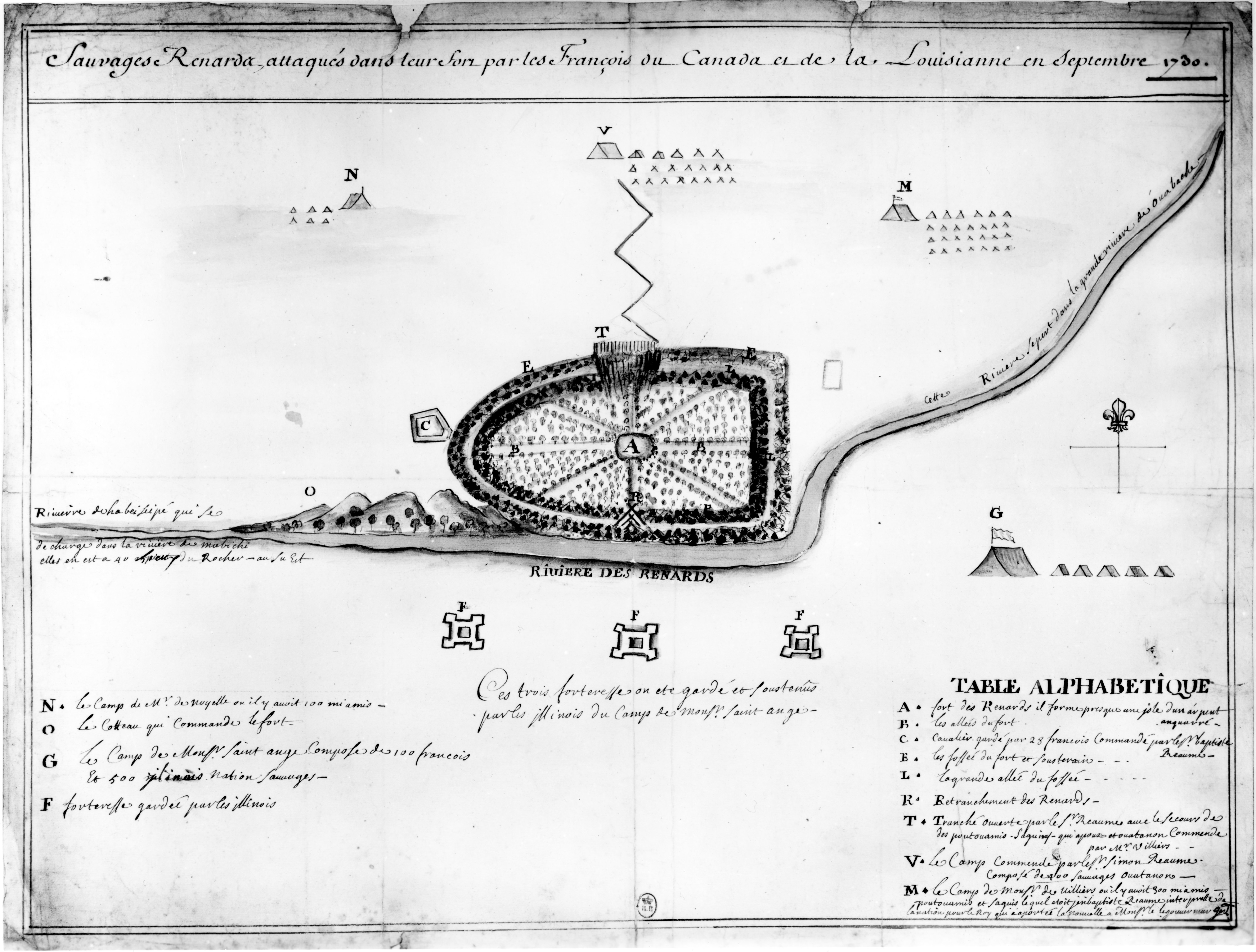
Figure 6. Sauvages Renards attaques. Click on images for larger views.
Undated and unsigned, Sauvages Renards Attaques is attributed to the Reaume Narrative by the present author. The draftsman clearly employed the Fort Des Renards for the spatial layout of the terrain and battle camp, applied some basic mapping conventions, but was unfortunately (from his perspective) required to add details after the completion of what he thought was his final draft. This last condition forces an unpolished and unrefined quality, specifically with regard to the apparent late addition of four map key elements in the lower left hand corner of the drawing, to what was most likely anticipated to be a finished document. All who have made maps share a sympathetic understanding of the circumstance. This personage was less skilled as an illustrator and more skilled as a cartographer than was the author of Fort Des Renards
Table 5. Translations of the information displayed on Sauvages Renards attaques.
1. Sauvages Renards, attaques dans leur fort par les Francois ou Canada et de la Louisianne en Septembre 1730.
Fox Indians, attacked in their fort by the French of Canada and of the Louisiana in September 1730.
2. TABLE ALPHABETIQUE [ALPHABETICAL TABLE]
A. The Fox fort is nearly in the form of an island of one arpent square [Note: An arpent equals 0.85 acres or 3425 square meters].
B. The paths of the fort.
C. Gun tower guarded by 28 French Commanded by Sr. [Mister] Baptiste Reaume.
E. The defensive trenches of the fort and dirt covering [back dirt employed as exterior slope of parapet].
L. The large path of the defensive trench.
R. Retrenchment [a secondary line of earthworks built to seal off a gap in the main line or to prevent a breakthrough] of the Foxes.
T. Trench opened by Sr. [Mister] Reaume with the help of the Potawatomis, Sauks, Kickapoos, and Ouyatanons commanded by Mr. [Monsieur] Villiers.
V. The camp commanded by Sr. [Mister] Simon Reaume composed of 400 Ouyatanon Indians.
M. The camp of Monsr. [Monsieur] de Villiers where there were 300 Miamis, Potawatomis and Sauks [and in] which there was Jean-Baptiste Reaume, interpreter of the Indian nation[s] for the King who brought the news to Monsr. [Monsieur] the Governor Gen[eral?].
N. The camp of Mr. [Monsieur] de Noyelle where there are 100 Miamis.
O. The hillside that commanded the fort.
G. The camp of Monsr. [Monsieur] Saint Ange composed of 100 French and 500 Illinois Nation Indians.
F. Strongholds/fortresses guarded by the Illinois
3. Note found below the three Illinois forts (Item F in the Alphabetical Table):
Ces trios forteresse on ete garde et soustenus
Par les Illinois du Camp de monsr. Saint ange
These three strongholds were guarded and supported
By the Illinois under duty to the Camp of Monsieur Saint Ange
4. Script found on or around the river channel:
Riviere des Renards
River of the Foxes
Riviere de la beiseipe qui se
de charge dans la riviere de Mabichi ells en est a 40 arpents (corrected on the sheet to lieue or leagues) du Rocher - au Su Est
River of the Beiseipi which itself
discharges into the river of Mabichi
It reaches as far as 40 leagues from Starved Rock - to the southeast.
cette Riviere (depart?) dans la grande riviere de Ouobache.
This river leaves into the grand river of Wabash.
The present author has previously discussed possible connections between these two charts. The Fort des Renards and the Sauvages Renards Attaques (Figures 5 and 6 respectively) appear related not only in historical perspective but also with regard to artistic representation. Peyser (1987) views the Fort des Renards as the simpler, less complex document. Expanding on that observation, it could be that it is the original drawing and Sauvages Renards Attaques is an edited, more detailed, and more stylized rendering. In the absence of historical information to the contrary, one might speculate that the original may even have been produced at the site. In any event, it is clearly a model for the Sauvages Renards Attaques. To observe these similarities one must first properly orient the Fort des Renards document by turning it upside down (north is not indicated) and secondly, the Sauvages Renards Attaques must be enlarged by 122% (no scale is indicated on either drawing). By then superimposing the two documents one discovers that (1) the positions of the St. Ange battlements are plotted in the same exact positions relative to the river, (2) the encampments of de Villiers, des Noyelles, and Simon Reaume are in the same exact locations, (3) the encampment of St. Ange has been shifted up approximately 1.5 cm to accommodate the space reserved for the key, and (4) the renderings of the fort proper display a fundamental coincidence, one neatly tucked within the other. There is a decided organic connection between the two illustrations although they were crafted by different individuals.
These final two illustrations seem to represent a significantly different interpretive perspective from those offered by de Villiers and St. Ange. There is the obvious difference in the geometry of the layout of the fortification, but just as important is the fact that neither of these maps offer any suggestion of a closed, perimeter defining wall, neither palisade, as in the situation of Carte du Fort, nor the twelve to fourteen foot long, crossed stakes all filled with earth, as in the situation of Plan du Fort des Sauvages. In these two documents the defensive perimeter is primarily constituted with a fosse. Each drawing, of course, has an exception: Fort Des Renards includes on the south and west flanks, sharpened stakes issuing from the back-dirt piled behind/above the fosse ("sharpened logs anchored in a shallow ditch and slanted to the exterior that dominate around the fort"); and Sauvages Renards attaques shows three parallel rows of vertical wood (?) elements directly opposite the French attack trench (there is no entry in the map key labeling or explaining this particular detail of the drawing). Somehow these renderings seem more credible. I have always wondered how or when the Meskwaki would have had the time or opportunity to collect the required wood and fabricate either a palisade or a robust wood framed parapet. Contrarily, one can dig and trench all night long, every night.
Conclusions: In conclusion, as archaeologists we are blessed with four distinct illustrations of the battle camp and the plan view of the fort, the five basic documents that we have just presented. It would seem an exciting circumstance. However, on analysis and comparison, we have discerned a suite of frustrating details:
(1) We need to make comment on two relatively fundamental map making conventions: orientation and scale. A North arrow is only employed on the Carte du Fort and Sauvages Renards Attaques. De Lery's directional indicator involves affixing the labels West and East on the left and right margins of the sheets. Fort des Renards gives no indication of directionality, although, as we have just argued, the view is to the south with north to the bottom of the sheet. Beyond this variation in technique there is a wide discrepancy in orientation of some elements of the battle camp. For instance does the river run west to east, were the cavaliers positioned on the west or east sides of the earthworks, and in what direction from the fort were the camps of the French forces and their attack trenches? None of the documents correspond with desired directional precision to what is observed today at ML6. My impression is that compasses were in rather short supply and direction was provided by dead reckoning with directional updates afforded by Polaris and the rising and setting of the sun.
With regard to scale, there is none on Fort des Renards, Savages Renards attaques has an implicit one when it informs that the fort was one arpent square (Note: An arpent equals 0.85 acres or 3425 square meters or 58.5 m squared), and both de Lery's work and the Carte du Fort provide a measurement scale in "Toise." The east-west interior of the fort on Plan du Fort is 78 toise or 152 meters, north-south is 38 toise or 74 meters (approximately 11,257 meters square). The area bounded by the walls of the fort in Carte du Fort measures 90-95 toise on a side or 175 meters by 185 meters (approximately 32,400 meters square). In summary, the estimates of the area of the fort as measured from the maps vary from no scale provided to 3425 meters square to 11,257 meters square to 32,400 meters square. I interpret this as representing a wide variation in scalar considerations.
(2) That said, perhaps the single most surprising observation to derive from even a cursory examination of the five documents is the wild disparity in something as seemingly simple and basic as the geometry of the fortification. It is a textbook example in interobserver variability and pathways for the determination of confidence levels. We have informally labeled the four "forts" the Vauban, the Amoeboid, the Trapezoid, and the Shield. We will return to a discussion of the possible causes of this compelling variation later in the report.
(3) The third critical consternation is the "wall": (1) one map shows an entirely enclosed palisade; (2) one map shows a major wood and earth enclosure but on only three sides; (3) one map shows only some sharpened stakes planted in back dirt and this but on two sides; and (4) one map shows no "wall" at all except directly opposite the attack trench where there is a short length of a triple row palisade. Simply stated, the illustrations of the "wall" range equally from four sides, to three sides, to two sides, to less than one side. Additionally, and as we have come to expect from the period documents, depictions of "wall" design and construction seem equally variable.
(4) On balance, the only Meskwaki defensive designs and constructions that are to be found on all four maps of the "fort" are: one, the excavated domestic bunkers/dugouts/earthcovered houses; and two, the excavation of an encircling fosse. With regard to documentary evidence, beyond these central facts there is only historical speculation and conjecture.
And so we return full circle to our point of departure, which representation of the fort is correct remains unknown. The methods of historiography fail to provide an answer to this critical issue. The real promise of archaeology for history is that answers to questions of historical speculation are potentially available in the ground and can be determined upon the application of proper archaeological technique. In this case, the validity of the drawings has potential for empirical determination.
This Native American society is known to itself as the Meskwaki or "People of
the Red Earth." While there are variant spellings and pronunciations of the name in the historical literature, Johnathan Buffalo (2003, pers. comm.), Meskwaki Historical Preservation Officer, suggests that the autonym is to be pronounced /Mesk-qua-kie'/. Some neighboring groups referred to them as the Outagami. The French most commonly employed the name Renard, which in English becomes Fox (Temple 1977:83).
The relationship between the Meskwaki and the French was never particularly
good. The first direct French contact with the Meskwaki is recorded by Father
Gabriel Druillettes in 1656 (Thwaites 1900:247). Father Druillettes reports
that "The two Frenchmen who have made the journey to those regions say that
these people are of a very gentle disposition." At the time of contact there
may have been 1000 warriors (Temple 1977:84) with a total population of perhaps
2500. The French trader and adventurer Perrot was perhaps the only Frenchman
to successfully interact with the Meskwaki. The exploitive and unscrupulous
actions of a variety of coureur de bois permanently disaffected them
from French culture. The Jesuits seem never to have made lasting inroads on
the Meskwaki lifeway. The Meskwaki remain to this day a fiercely independent
and deeply religious society.
In the first half of the eighteenth century the Meskwaki became embroiled in
at least three major periods of conflict with the French (Edmunds and Peyser 1993). From the French
perspective they consistently blocked French economic interests and spread
dissention and conflict among the native peoples of the region. After the
defeat of the Meskwaki at Detroit in 1712, they preyed upon the French and
their Indian allies throughout the region of the upper country for four years.
During the period from 1719 to 1726 the Meskwaki were again at war with the
Illinois and, by virtue of this, the French. Their raids extended as far as
Ft. de Chartres in southern Illinois. In 1726, in spite of a confused response
on the part of the French, a formal peace was concluded.
By 1727 the French were again expanding trade contacts with the Sioux and
other societies of the upper Mississippi basin. French success in this venture
depended on water routes cutting through central Wisconsin and hence the heart
of the Meskwaki homeland (Figure II.1). The Meskwaki resisted this incursion. The French
response during this final period of conflict was attempted genocide.
By early summer of 1730, the Meskwaki had determined to abandon central Wisconsin. They would attempt a move to join with the Iroquois in the modern state of New York. The Iroquois were allied to the English and traditional enemies of the French. In order to acheive this exodus the Meskwaki would have to pass around the southern end of Lake Michigan. The French were alerted to this activity and fielded forces to intercept the move. The Reaume Narrative reveals that de Villiers had wandered some 100 leagues with a party of some 350 warriors before giving up his search for the Meskwaki and retiring to Fort St. Joseph. The Meskwaki had eluded contact by swinging well wide of southern Lake Michigan. Their apparent plan was to move straight south from the homeland west of Lake Winnebago, to the Rock (Starved Rock) where they hoped to negotiate a safe passage through the lands lying to the south and east. Such a negotiation would be complex but such were the relationships between the two societies that it was at least possible. The negoiations went poorly according to Reaume. The Meskwaki sent an envoy to the Illinois to ask for the right to pass through. In the council cabin an angry young man struck out at the envoy with a tomahawk and with a knife. This aggressor was put outside and the council continued. At the meeting's conclusion, the Meskwaki emissary retired to his village some five leagues from the Rock. Five days later he killed or had killed some Illinois. No documents reveal the particular personal motivations of the central actors but the rules of blood feud and restoring face seem likely explanations. The St. Ange Narrative adds that it was the son of a "chief" of the Cahokias that was captured and subsequently "burned." I have long speculated that it was he that had violated the rules of decorum in the council meeting by producing his tomahawk and knife. It was a heavy price to pay for rude behavior.
In any event, the Meskwaki had failed to gain the desired permission and were instead now being shadowed by an angry group of Illinois anxious for revenge. It seems likely that they exploited the corridor forest of the Vermillion River of the Illinois for travel and sustenence. It drains northward from the south and east.
The French attempt at genocide culminated with the Meskwaki defeat on the prairies of east-central
Illinois after a twenty three day siege. By 1733 fewer than 100 Meskwaki
remained alive (Tanner 1987:42).
Figure II.1. Carte du Pays des Sauvages Renards. Click on image for a new window and a larger view, click again for the maximum view.
The chart is dated 10 November 1730 and signed by Chaussegros de Lery, chief military engineer of New France. De Lery signed off on Carte du Pays des Sauvages Renards, Blocus du Fort (Figure XXX), and Plan du Fort des Sauvages (Figure XXX) on the same day. With the southwestern tip of Green Bay (Partie de la Baye du Lac Michigan) along the right margin and Lake Winnebago (Lac du Puants) in the center, the drawing is of central Wisconsin and the Meskwaki (Renard) homeland.
The caption reads:
Map of the Country of the
Fox Indians, From the Bay of Lake
Michigan to as far as their last Village
Note the three Renard villages and associated fort. It is primarily from these three villages that the Meskwaki would begin their journey that ended at the Arrowsmith Battleground (11ML6), some 250 miles to the south.
Ironically, it is at the Village des Sacqui [Sauk village] that Lt. Coulon de Villiers, the victorious commander of the allied forces during the 1730 siege, would lose his life but one year later in his pursuit of those Meskwaki that had managed to escape the operation of his forces in the aftermath of the siege. The Sauk refused to surrender the Meskwaki in their village. De Villiers failed to appreciate the strength of the Sauk obligations and sympathies. When he determined to force the situation by rushing the village, he was shot.
McTaggart (1973:170-171) relates part of the Meskwaki oral tradition
recalling this event. It provides some sense of the Meskwaki people and is
recounted here in this spirit:
It was back about the same time that White Robe lived; it happened in 1732
[sic] in Illinois when the Meskwakis were surrounded in the forest. We were
surrounded on all sides by other Indian tribes and by the French and we
couldn't get away.
There were two leaders. And they took the sacred bundle and started leading a
song, a sacred song. And they drummed and they sang and they chanted until the
other side all fell asleep.
We had two runners, what you might call messengers. We don't have them any
longer. And these two runners took a sacred wolf skin down to the river. And
they were supposed to drag it lightly across the river to produce a fog.
But I guess they got overanxious in their duty and they dipped it in the
water, dipped it in so that it was all covered up with water. On the
top of it: they dunked it in the water. I guess they wanted to be sure
that it would work. But instead it produced too much fog - a lot of rain and a
lot of moisture in the air.
So while these people were all sleeping, the Meskwakis were to crawl away
through this fog. As we were crawling over these sleeping bodies, we were
being led by these two men who had taught us how to get away. One man's name
was Mamasa: he was the drummer who had helped put the enemy to sleep. And the
other man's name, I can't remember.
But as our people were crawling over the sleeping bodies, the fog was so thick
that we couldn't see each other. So in the middle of the line, somebody lost a
hand hold and we couldn't see each other, so one group went in one direction
and the other group went in the other direction.
And the other group got lost from us.
While this narrative does little to pinpoint the location of the fort, it is
intriguing in its own right. During this period the Meskwaki were surrounded
and heavily out numbered by the French four times. On three of these occasions
they were able to employ the weather (a fog, a rainstorm, and a snowstorm) to
escape and survive (McTaggart 1973:174). Moreover, all of the French accounts
of the siege remark on the singular nature of the storm that struck on the
night of 8 September 1730. De Villiers states that it suddenly began an hour
before sunset and lasted into the night "...so that, in spite of all I could
say to our Sauvages, I was unable to make them guard all the outlets."
(Thwaites 1906:117). Reaume's narrative adds that the Meskwaki "... made a
large fire...." inside their fort that night and thus forewarned him of their
escape plans.
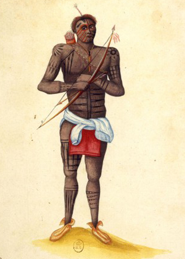
The image is of a Meskwaki warrior that survived the siege. The water color is of an armed Meskwaki man that was captured by the Miami Nation and offered by their commandant, De Noyelles, as a slave to the Intendant of New France, Gilles Hocquart. In a communication to the Minister, dated 14 November 1730, Hocquart details that Colon de Villiers' son had been charged with the responsibility of personally carrying the news of this great victory over the Renards back to France and to also convey the captured warrior, now a slave, to Rochelle, France for imprisonment. Source: Archives Canada France
The caption located below the painting reads:
Guerrier Renard. Redoute par toutte les Nations, Par leur Valleur et Vitesse, Faisant 25 a 30 lieues
Par jour Sans Autre Provision que les Herbes et les Feuilles des Bois
ils sont Environ 4 a 500 Homme portant Les Armes
Divises en 3 ou 4 Village, De Puis Qu'ils ont la Guerre Avec Les Francois
Presque touttes les Nations Prennent la Maniere De Se Faire Les Cheveux A La
Renarde
Quand il ont Une Chemise, il la Mette En Braquet Quand il Faut Qu'il se Batre
Translation:
Fox Warrior Feared by all nations for their valor and speed, capable of going 25 to 30 leagues a day without any food other than plants and leaves from the woods. There are about 400-500 men bearing arms divided into three or four villages. Ever since they have been at war with the French, almost all the nations have been doing their hair Fox-style. When he has a blouse/shirt, he wears it in turned (or fixed) whenever he needs to be ready to fight.
In a document associated with the folio within which the water color image was filed, we find some further information regarding the man's circumstance:
Sauvage // Renard // Sauvage Renard fait [made] prisonnier // amene [somewhere] a Quebec en 1731 a M. de Beauharnais // gouverneur et Lieutenant general de la nouvelle // france, et envoye par luy en france pour estre // mis aux Galeres. // Ce Sauvage a este longtems dans la prison // de Rochefort et y est mort l'annee // Suivante. Source: Library of Congress
Translation:
Fox // Indian// Fox Indian taken prisoner // somewhere in Quebec in 1731 by M. de Beauharnois // Governor and Lieutenant General of New // France, and sent by him to France to be // put in a prison galley. This Indian was to be a long term prisoner // at Rochefort and he died the following // year [1732].
To my knowledge, Guerrier Renard is the earliest illustration in the European tradition of a Meskwaki. It is dated in the associated expication at 1731 although there are no year references on the drawing itself. The identity of the artist remains unknown.
Observations concerning the image are several. First, my sense of it is that the image was created in France. This would explain some of the garbled elements of the explication associated with the document. One aspect of the explication that I am willing to accept is that the man did not fare well in prison, or perhaps more correctly, to the "galleys" with regard to which there are several references, and that he died within the year. He died on foreign soil and never again saw his homeland in the Upper Country.
Second, the skin art is most intriguing and its detail in the water color suggests that the artist also found it to be so. Life history and clan affiliation seem likely themes. It is difficult to judge what is paint, tattoo, or scarification. The reference in the caption to how all the Nations are doing their hair Fox-style, with the distinctive scalp lock, seems significant because of what it says with regard to the vaguaries of hair style, the influence the Meskwaki had on neighboring Nations, and to the bravado of Meskwaki warriors. Exactly how our artist would have knowledge of Upper Country fashion remains unanswered.
His dress is limited to the breechcloth, the mocassins with their distinctive style, and the blouse or shirt tied around his waist. That the artist would draw our attention to how the shirt is tied for battle seems curious, but the subject is after all a warrior.
Lastly, I would turn to the subject, himself. It is curious that the social context of the studio afforded the prospect of his being re-armed. It might have been less dangerous for the artist to simply add the bow and arrows to the image after the sitting. Such was not the case and I think lends a certain authenticity to the image. However, if you examine how the bow, arrow, and bow string are positioned in relation to the hands, you would note that the weapon is not in a position to be readily fired. The bow is being held in the right hand (judging from the location of the quiver, the man was right handed, which places the bow in the wrong hand for nocking and firing, although he was likely quite capable of hitting a close, human sized target from an off-hand firing position) and the string is to the outside of the wrist. Finally, I am drawn to comment on the subject's facial demeanor and gaze. He seems poised, relaxed, and yet very alert and ready, with his gaze focused on something or someone to his right. Could it have been someone, like say a guard, who was aiming a musket in the full cock position at his center of mass while he was in possession of the weapons. Such might seem logical given how the caption clearly conveys the respect with which the battle prowess of Meskwaki warriors was held by the French.
The second image (Figure II.A.2.) is dated some five years after the fall of the fort. One or more of the subjects may have participated in the siege.
Figure II.A.2. Desseins de Sauvages de Plusieurs Nations, N.lle Orleans 1735 or Indians of several Nations bound for New Orleans 1735. For a more detailed discussion of the painting, please visit our Inoca Ethnohistory web site. Click on image for larger view. (Image used with permission. Peabody Museum, Harvard)
In 1735 a French artist, Alexandre de Batz (1685 - 1737), created this water color. The caption reads, "Indians of several Nations bound for New Orleans 1735." The seated female is labeled "Fox [Meskwaki Nation] female Indian captive." De Batz actually employs the word esclave rather than captive but understand that the Inoca notion of slavery was quite different than that of the Spanish, French, English, or later, American. The woman had most likely been taken as a captive and subsequently adopted by an Inoca family as part of one of the interesting ritual acts of the people of this region of North America. Note the presence of the "Negro" (African) child (this is the earliest depiction of an African associated with the Pays des Illinois). The adult male to the right of the African child is labeled "Atakapas" (a native society from the Gulf Coast of Louisiana and Texas). All others in the image are "Illinois." The man standing to the left is labeled "Chief" while the crouching male is labeled "Dancer." It seems possible, even likely, that the Meskwaki woman and the four "Illinois" men participated in the siege. If not, then they certainly had family members and friends that did.
A final note on the French notion of "Fox [Meskwaki Nation] female Indian captive" comes from an interesting on-line resource provided by the Illinois State Archives. The searchable database is labeled the Servitude and Emancipation Records, 1722-1863. The following entry in the database was extracted from the French Registre of Insinuations, 1737–1769 and is associated with modern Randolph County, Illinois.
Servitude Detailed Information
County: RANDOLPH
Name of Servant: MARIE
Name of Other Party: CHAUVIN
Sex: Female
Race: Indian
Age: Unknown
File: KM
Volume: Page 1
Document Type: OTHER
Amount: $0.00
Term of Servitude: Set Free
Date 06/08/1765
Remarks: INDIAN PRISONER OF WAR, SET FREE
Memo: ". . . MARIE, A FREE FOX INDIAN WOMAN, FORMERLY SERVING CHAUVIN. SHE WAS TAKEN PRISONER BY THE FRENCH DURING THEIR WAR WITH THE FOX. DUE TO ILL TREATMENT, SHE CHOSE TO LEAVE CHAUVIN, WHO THEN ILLEGALLY TRADED HER TO TRUDEAU FOR 2 YOUNG INDIAN SLAVES. COURT HAS SEEN THE WRITTEN TESTIMONY OF MAY 16, 1765 BY THE GREAT CHIEF OF THE FOX NATION, THAT HIS NIECE MARIE IS A FREE WOMAN, AND ALSO THE TESTIMONY OF THE GREAT CHIEF MEQUAC. COURT WISHES TO AVOID A WAR WITH THE FOX NATION AND FINDS FOR THE PLAINTIFF, WHO IS DECLARED TO BE FREE. . . . CHAUVIN IS ORDERED TO RETURN THE 2 SLAVES HE TOOK IN EXCHANGE FOR HER."
It is not known which French "...war with the Fox." is being referenced, but the seige is considered to be the end of the Second Fox War, and indeed, the end of the Fox Wars. It is possible, therefore, that "Marie" had endured her captivity as a "prisoner of war" for some 35 years. I would consider Marie's condition to have been one of slavery and would choose to discount the fact that the document declares it to have been illegal even as it grants her emancipation.
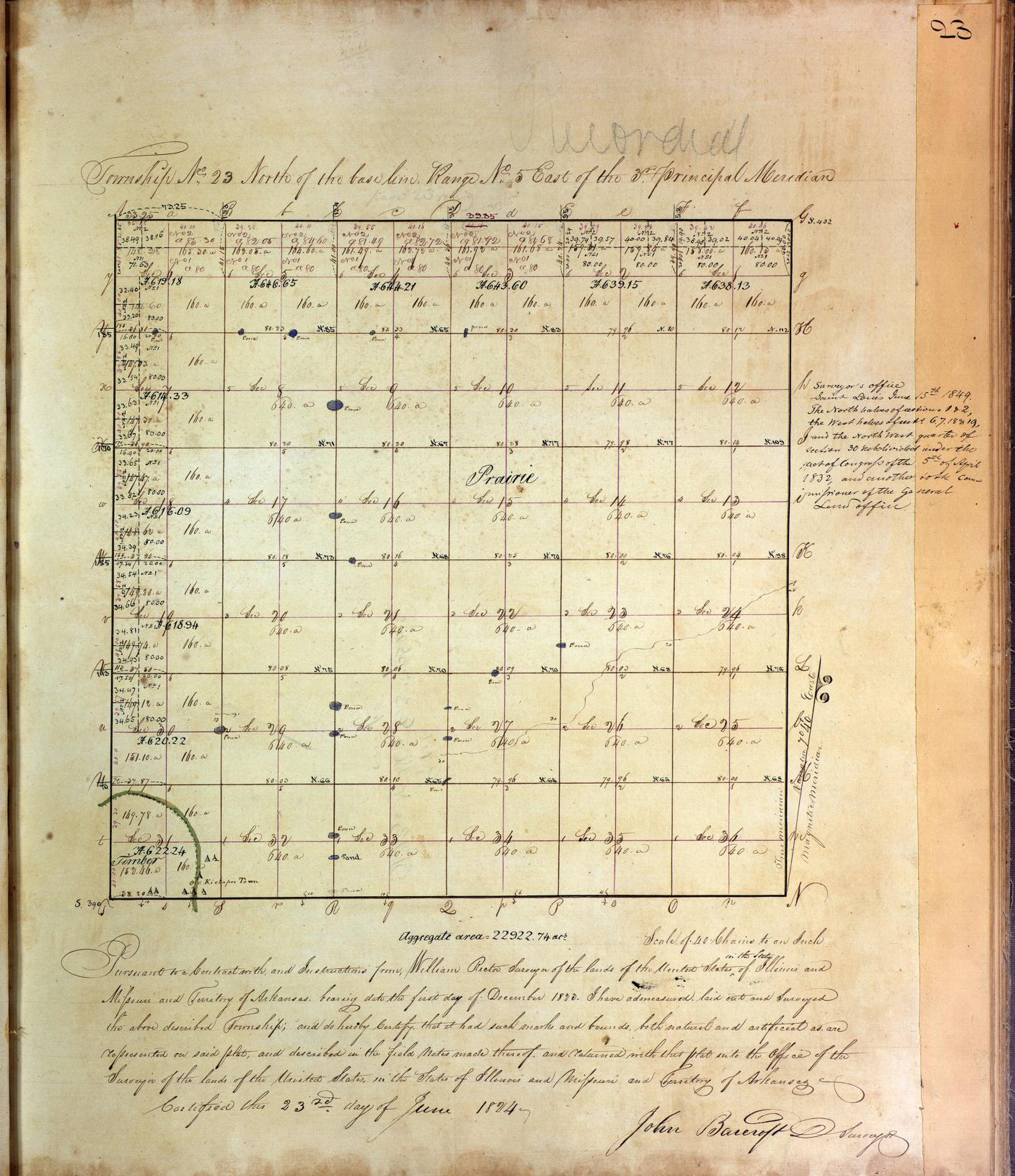
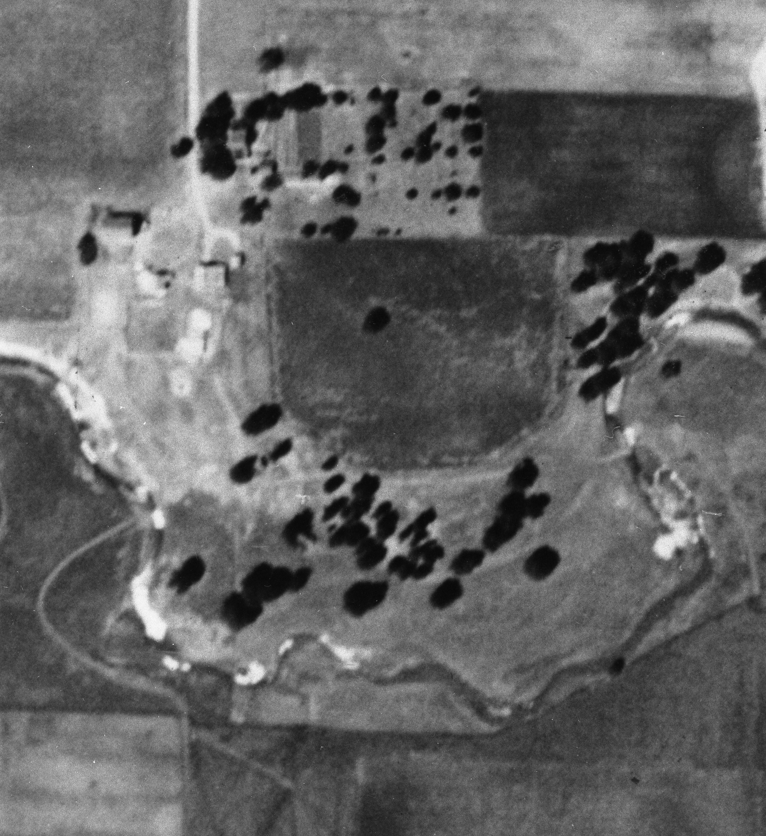
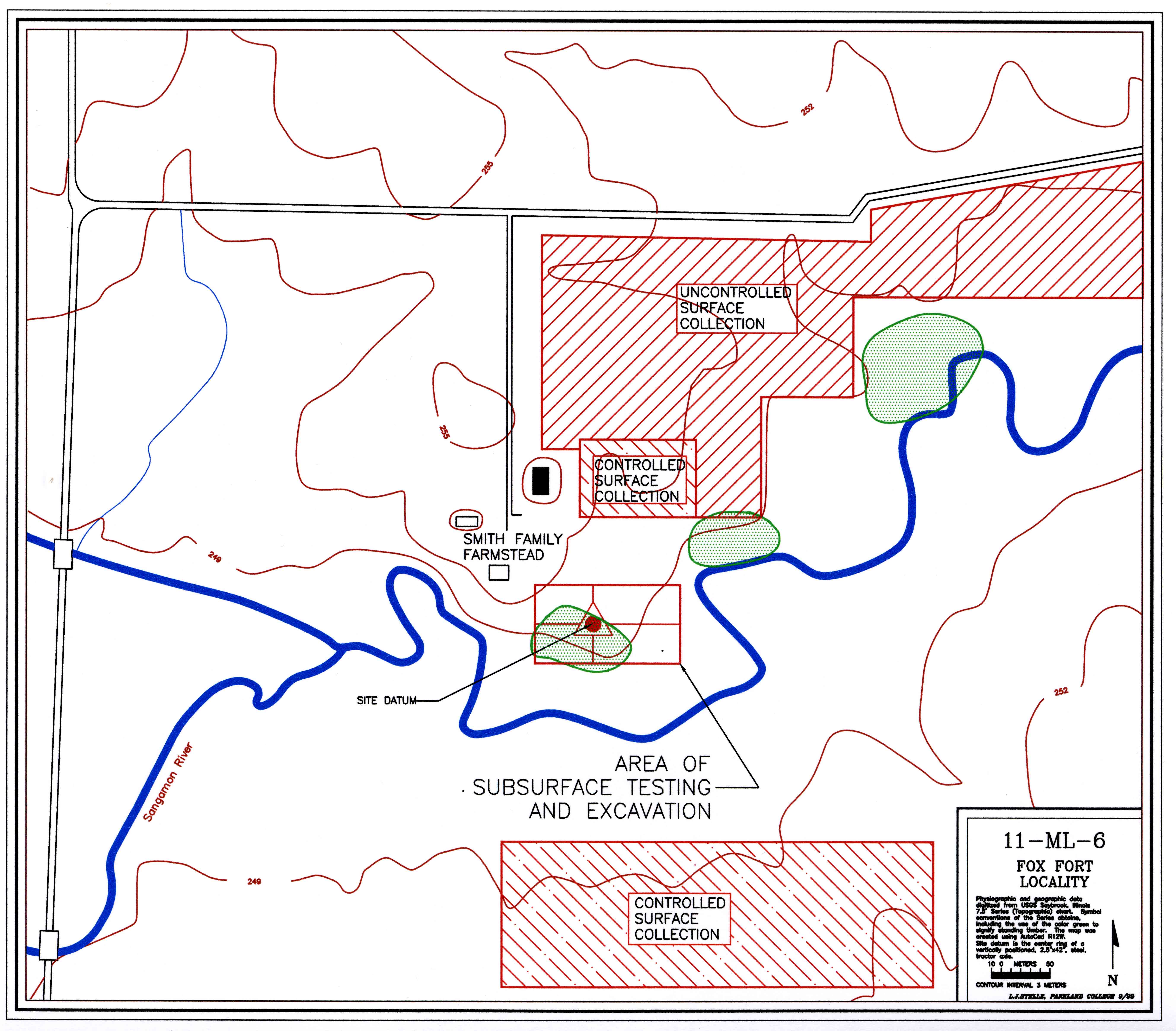
Ml-6 is situated on the headlands of the Sangamon River. The GLO township
survey maps of 1824 (Figure III.A.) indicate that the river became intermittent less than four
statute miles to the southwest (upstream). The documents show the river flowing to the east through
seven sections before turning to the southeast. It then extends another thirty
miles before turning back to the west. The river rises between two of the
recessional moraines associated with the Peoria Sublobe of the Woodfordian
Glaciation. The deposition would have occurred between 14,000 and 15,000 years
ago (Willman and Frye 1970:94). The presumed location of the fort is upon the
crest of a small knoll 250 meters east of the confluence of an unnamed
tributary. The valley carved by the tributary is 150 meters wide where it
drops to the floodplain of the river.
The little knoll is an element of the Sangamon's north valley wall. The wall
rises in a relatively abrupt fashion in this place to an elevation 5 m above
the floodplain. Its drainage and slope is generally northwest to southeast.
The terrain lying about the knoll is described by the GLO surveyor, John
Barcroft, as "broken" (Barcroft 1841). To the northwest of the site, the land
evidences a few, small ice-contact features of higher elevation. To the north
and northeast, the land assumes a gentle roll. It gains elevation and crests
on the Normal Moraine some several kilometers to the north. Across the river
to the south, southwest, and southeast, the floodplain is quite wide and level.
There is no well defined valley wall in these directions. Approximately 2 km
to the south one encounters the crest of the Bloomington Moraine.
An examination of the soils suggest stratified sands and gravels of glacial
outwash covered with a thick mantle of loess. They are often quite eroded.
Barcroft describes the soils in 1841 with references like "gravelly, poor, and
second rate" (Barcroft 1841). The soils were most recently surveyed in
February of 1988 (McLean County Soil Conservation Service, personal
communication) and form a Saybrook silt loam (1 to 4 percent slopes) and
Drummer silty clay loam association on the uplands. The valley wall is an
eroded 5 to 10 percent slope and is identified as LaRose silt loam. The
floodplain alluvium is typically Sawmill silty clay loam. These prairie soils
are quite acid and contribute to poor faunal preservation.
The floristic communities of the site would have been dominated by the
Dry-mesic Upland Forest and the Mesic Prairie (see White and Madany [1978] for
greater detail on the natural communities of Illinois and Stelle [1987:17-24]
for their expression in the upper Sangamon basin). Of significance here was a
fifteen acre, oak-hickory timber. Known as Small Grove or Smith's Grove, less
than two acres survive. The grove was so small and centrally located in
Section 24 that it failed to receive mention in Barcroft's field notes. A
little island of timber surrounded by a sea of grass, it could likely have been
the most upstream manifestation of the corridor forest bordering most of the length of the Sangamon River. The Mesic Prairie community would have dominated the encompassing landscape. The floodplain might properly be
viewed as a tall grass, prairie slough through which coursed a slow, shallow
Sangamon River. The surrounding uplands would have displayed more xeric
elements of this association.
Among the sites that have been offered as the location of the siege, Ml-6 is
unusual in that it has been the object of two earlier "archaeological"
investigations: one by Captain John Burnham in 1897 and the second by William
Brigham in the 1930s. While a few recent authors have accepted the
interpretations of these studies (Tanner 1987:42), more have equivocated
(Callender 1978:644; Temple 1977:90), and most have remained unconvinced
(Peyser 1980:208; 1987:154). The issue has at times been so clouded that the
editors of a 1960 Illinois Archaeological Survey publication felt the need to
follow one of Brigham's articles with a five page statement (Bauxar
1960:101-106). A review of the two reports is warranted.
In May of 1897, Captain John Burnham (1897;1908) (Appendix F. Burnham Narrative) in association with
"...several pioneers of eastern McLean County and a few members of the McLean
County Historical Society...." excavated "...four or five of the dozen or
fifteen of the pits...." located on the crest of the knoll. While he fails to
differentiate their recovery from objects "presented" to them, he lists 200
lead balls; a few arrowheads or points; charcoal and ashes; bones of animals;
knife blades (one bearing the maker's mark, Pierre Minan); a lock from a flint
lock; parts of two gun barrels each of which had been flattened on the ends;
pieces of copper ornaments; pieces of nearly straight "deer-horn prongs"; and
several pieces of iron. All of these objects are now lost.
With regard to the features they excavated, no maps or drawings are recorded.
He states that the "pits" were irregularly spaced and shaped. They first dug
into the ridges surrounding the depressions (mostly clay or sub-soil) and found
them devoid of material. Turning next to the depressions, they found them rich
in material with bottoms two to three feet below the natural level of the
ground. The largest was fifteen feet in diameter at the top and eight or ten
feet at the bottom. All contained "mostly" animal bones (poorly preserved),
ash, and charcoal.
Burnham also relates descriptions of zig-zag earthworks lying some 825 feet to
the northeast of the knoll. These structures had been plowed to obscurity by
the time of Burnham's visit.
The second published account that involved excavation was by William Brigham
(1936), who visited the site in 1932 and 1934. The 1934 dig was done in
association with the McLean County Academy of Sciences. Both visits were
likely one day affairs. At least another ten "pits" were exposed by a trench dug
across the hill in a northerly direction. Importantly, Brigham's indication
that the 1934 event was "A more systematic investigation than any of recent
years...." (1936:37) suggests that serious collecting from this site was an
ongoing process. The 1932 probes yielded charcoal, bones, teeth, an arrow
(?), and a bullet. The 1934 trench provided worked soil, bones, charcoal, a
piece of sheet copper, a number of bullets, and a short section of gun barrel.
The artifacts illustrated in the report may include the material
recovered, but certainly include much undescribed and unprovenienced data as
well. Some of the artifactual material attributed to this effort is reposed in
the collections of the McLean County Historical Society (Martin Wyckoff,
personal communication).
Beyond the two published accounts, during the second half of the twentieth century there were likely also a number of probes of the site by members of the professional archaeological community. None of these investigations apparently resulted in significant new findings or insights. Revealed through personal communication is a notable selection of mid-century Illinois archaeologists including (institutional affiliation at time of reconnaissance in parentheses): John McGregor (University of Illinois), Edward Jelks (Illinois State University), Robert Hall (Illinois State Museum), Warren Wintry (University of Wisconsin), and James Porter (University of Illinois). It is not clear that Porter actually excavated on ML6 but he completed a thin section analysis of some excavated mafic tempered, Upper Mississippian body sherds. The only surviving documentation of these visits is the Illinois Archaeological Survey's completed site survey form (by McGregor). We have no idea how much or where soil was turned. With the exception of Robert Hall's effort's (holdings of the Illinois State Museum) all recovered materials are now lost.
In summary, several observations are in order. First, this is the only
proposed site of the fort for which any archaeological information is available
other than Steward's "old French battle axe" and "French gunflint" (1908:255)
from Maramech Hill. Second, Brigham's efforts removed the last of the original
deposition visible from the surface. The "pits" that can be seen today are the
product of large scale and unreported looting. Clearly, if the site only
consists of a single, twenty-three day occupation it is at considerable risk of
being destroyed. Thirdly, the poor, if understandable, quality of these two
studies renders any archaeological inferences suspect. The information about the
general location and nature of features and about the relative abundance of
musket balls seems credible. One can reasonably conclude that some sort of
military engagement transpired here in the eighteenth century. However, these
studies fail to provide adequate archaeological support for their inferences
regarding the identities of the combatants or a more specific temporal context.
In conclusion, given the site's potential importance to the history of the
region, its limited deposition, the potential yield in information regarding a
major armed struggle, and the vague quality of the existing research, we initiated a formal archaeological reconnaissance.
Research Goals
The basic goal of the
present work was to conduct an archaeological reconnaissance of this locality and
to establish base line data from which culture-historical inferences could be
made and resource management recommendations based. Ml-6 has the potential to
yield answers to a variety of research questions focusing on how regional
Native American social systems functioned during periods of critically high
stress. This is true regardless of the identities of the combatants.
Questions of interest included (1) fortification design and construction,
(2) religious and ceremonial activities, (3) dietary considerations, (4) both
internal and external economic interactions, (5) production trajectories
associated with war materiel, (6) enhanced estimates of the sizes of family
units based on the dimensions of domestic architectural units, (7) medical
practices centering on the care of the wounded, and (8) mortuary practices.
The prospect of being able to address such questions at this site makes it
unique. By comparison, the nearby Kickapoo Fort at the Warren Bane Site (11ML5) fails
to provide evidence of military operations or siege conditions (Smith 1978).
In answering these questions a secondary set of issues can also be addressed.
This study is obviously concerned with the prospect that Ml-6 is the site of
the 1730 siege of the Meskwaki. In which case the site must demonstrate the
presence of the Meskwaki, the French, the fort, and temporally sensitive data
centering on a 1730 horizon.
Lastly, the reader is advised that Ml-6 is potentially a very large site when outlying encampments of combatants under French direction are considered. What is offered by way of
results must be viewed in a tentative fashion and as a report on work in
progress.
Data Collection Techniques
B. Aerial infrared photography
C. Surface reconnaissance
D. Shovel probe subsurface testing
E. Excavations
Site datum was established at UTM coordinates zone sixteen at 365384.2935 E, 4477147.299 N and elevation 249.9198 m above msl. At this place was buried an iron reinforced, eight inch by four foot column of concrete. To the exposed top of the column was embedded an aluminum dome top bench marker upon which was stamped an X.
The data collection techniques employed consist of six distinct elements
(Figure 6-3):
1. An infrared aerial survey of slightly more than the northwest quarter of
Section 24;
2. An initial uncontrolled surface collection of cultivated farm lands (surface
visibility >95%);
3. A controlled surface collection of cultivated farm lands where artifactual
material was encountered during the uncontrolled collecting (collection units
were 20 m x 20 m, transects were on 3 m intervals, and all recovered items were
piece plotted);
4. A shovel probe survey based on a grid interval of 2 m over the top of the
knoll thought to be the location of the fort (this ground is either in improved
pasture or alfalfa with surface visibility <5%);
5. A metal detector survey sweeping the north-south and east-west lines of the
collection grid (see the following discussion regarding sampling design);
6. A total of twenty-four test excavations, four of which were 2 meters square,
fifteen were 1 m x 2 m, and the balance were 1 m x 1 m.
The test grid for the shovel probe and metal detector surveys necessitated a
sampling design. Focusing on the top of the knoll described as the locality of
the fort, we arbitrarily established a grid 150 m east-west and 80 m
north-south. Working on 2 m centers, a random sample of approximately 5.4
percent of the grid intersects were selected for probing (N=165). This was
achieved by choosing 15 north-south lines and 11 east-west lines. By selecting
the sample in this fashion greater control could be realized in locating the
collection points and the metal detector sweeps could use the identified lines
as transects.
The controlled surface collecting occurred wherever the land afforded
visibility greater than 95 percent and whenever human resources were available.
This activity was seasonally adjusted to crop production.
The test excavations were initially positioned in response to the discovery of
subsurface deposits identified by the shovel probes.
Figure IV.F.2. Magnetic Map of ML6. Click on image for larger view.
We also see in the magnetic data a number of linear anomalies. These are particularly relevant given our focus on detecting evidence for the defensive fortifications and the attack trenches that are documented by historic maps and narratives.
The ML6 is not an ideal site for geophysical investigation. The biggest problem is magnetic clutter, which refers to all of the variations in color that appear in the magnetic map that do not relate to the archaeological component of interest. Clutter can include plow furrows, rocks, tree roots, rodent burrows, modern metallic debris, livestock paths, and natural burning. The north half of the site is in an agricultural field whereas the wooded southern half is used as pasture. The two areas have long been separated by wire fences (Figure IV.F.3.) that are a major source of magnetic clutter (these wire fences have been variously established, repaired, relocated, and removed, all of which are activities leaving iron debris on and in the ground). Also unfortunate was an earlier generation's decision to burn discarded roofing material in the pasture (Figure XXX. SLIDE 13: clutter). We assume that roofing nails and possibly burned soil account for the concentration of anomalies we see just south of the current fence.
Figure IV.F.3. Major sources of magnetic interference.
We tried several approaches to filtering out the clutter (Figure IV.F.4.). As previously indicated, we found it useful to simply mask many of the magnetic anomalies with a mid-range shade of grey. This makes it much easier to tease out the linear magnetic anomalies that are associated with the defensive fortifications and the attack trenches.
Figure IV.F.4. Gray screens applied to magnetic image.
As an additional attempt at filtering clutter and triangulating possible features not visible from the surface, we employed the Geoscan RM15 to collect electrical resistance data from eight of the already described 20 meter square collection units. Figure IV.F.5. presents the electrical resistance data (within the yellow rectangles) positioned within the surrounding magnetic data. While the resistance data seemed not to reveal as much of the site's fine structure as we had hoped, we do see that some of the linear anomalies apparent in the magnetic data are also present in the resistance data. This removes the possibility that those lines are, in some way, simply related to old fences, etc.
Figure IV.F.5. Electrical resistance data superimposed (within the yellow rectangles) on magnetic data. The resistance data are shown atop the magnetic data within the yellow rectangles. The resistance data are not as useful here as at some sites, but we do see that some of the linear anomalies apparent in the magnetic data are also present in the resistance data. This removes the possibility that those lines are, in some way, simply related to old fences and such like.
We have also found it useful to step back a few thousand feet and look at the magnetic anomalies in the broader context of natural and cultural features seen on aerial photographs (Figure IV.F.6.). Here we see the magnetic data superimposed onto a recent color infrared aerial image. The current channel of the Sangamon River essentially encircles the site on three sides. A section of one abandoned channel sometimes still holds water. At least one possible buried channel is visible in the magnetic data.
Figure IV.F.6. Magnetic image superimposed on color infrared aerial photograph of ML6 locality.
A comparison of the geophysical plots to the four conflicting historical images of the fortification reveals that the best correspondence is with the highly detailed, curvilinear Carte du Fort map (Figure 4.). We imported the Carte du Fort map into a graphics program (Stelle to Mike: which graphics program?) and highlighted the river in blue, the positions of the attacking forces in black, the outer edges of the fort in green, and the inner edges of the fort in yellow (Figure IV.F.7.). We then superimposed the map onto the geophysical data, and experimented with various orientations and scales. We did not, however, alter the map's proportions or internal arrangement of features. (Figure IV.F.8.) You can see how well the yellow outline of the fort's interior edge corresponds to the magnetic anomalies in Figure IV.F.9. Note how the (blue) river channel roughly corresponds to the faint light colored anomaly that may be a buried channel. The north and east portions of the inner edge of the fort match-up very well with magnetic anomalies. The "pointed areas" located at the center and east end of the Carte du Fort's north wall are visually prominent and we see indications of these in the magnetic data (Figure IV.F.10.). These may not have been formal bastions, but they may well have inspired the exaggerated bastions that appear on one of the other French maps. We are uncertain what is being depicted on the Carte du Fort map by the long section of wall that protrudes out from the fort, into a garden or area cleared of trees. This extension of the fort may have been intended to ensure the defender's access to crops that had not yet been harvested. Whatever its function, this extension from the fort corresponds roughly to a curving magnetic anomaly. The positions of attacking forces located north of the river correspond reasonably well to linear magnetic anomalies, although the anomalies are much larger than the positions transcribed from the map. Of particular interest is the "zigzagging" attack trench located east of the fort. Although the magnetic anomalies do not conform exactly to this trench's complex configuration, the anomalies do exhibit several sharp changes in direction. This configuration was presumably intended to prevent the defenders from firing directly up the length of the trench.
Figure IV.F.7. Carte du Fort with significant elements highlighted in color. The river is in blue, the positions of the attacking forces in black, the outer edges of the fort in green, and the inner edges of the fort in yellow.
Figure IV.F.8. Carte du Fort color lines only and with image rotated 30 degrees counterclockwise.
Figure IV.F.9. Carte du Fort color lines, correctly oriented, superimposed on magnetic image. Click on image for larger view.
Figure IV.F.10. Carte du Fort color lines, correctly oriented, superimposed on magnetic image. Specific regions of correspondence highlighted with white circles.
Our comparison of the magnetic data, confirmed in part by the resistance data, force us to conclude that the Carte du Fort map generated by the French forces from Ft. de Chartres and under the leadership of St. Ange, provides the most accurate geometric correspondence to ML6's archaeological reality.
Ground Truthing the Geophysics in 2006
Building upon the geophysical data, a total of seven test units (Figure IV.F.11.) were opened during the summer of 2006 by the students of a Parkland College archaeological field school. As predicted by the geophysical surveys, all encountered regions of disturbed subsoil and what we have interpreted as features. The first four units were positioned in response to some of the magnetic survey's more provocative linear anomalies. They were intended to allow us to address firstly, the validity of our interpretation of the survey imagery, and secondly, the intriguing correspondence between these anomalies and the details of the Carte du Fort map. Later, units 5, 6, and 7 were added to extend our understandings of what we had already excavated. The results of our analysis afford the recognition of at least three new feature types.
Figure IV.F.11. The location of the seven test units opened in 2006. Shown in relation to some of the more interesting magnetic anomalies. Click on image for larger view.
Test Unit Descriptions and Interpretations
1. Test Unit 1: (Figure XXXX. TU 1_06_profiles.dwg) Test Unit 1 (unit datum grid coordinates W12.1 meters, N41.4 meters) was oriented EW and measured one by two meters. Excavation revealed much sub-surface disturbance when compared to the profiles of the other six units. Our best interpretation is that two crawl-ways intersect, one running NS and the other EW. The EW ditch was the first activity. The issue of the NS intersecting ditch is confused by the fact that there were two construction episodes with the last and most robust expression involving a 75 cm shift to the east. The realignment is best observed in plan view at 25 cm below surface. In profile the evidence on the south wall is quite distinct and on the north wall probably is best reflected in the slump centering at 130 cm east. As indicated in the profiles of the east and west walls of the test unit, the first construction resulted in a ditch >91 cm wide and 49 cm deep. The final construction episode of the NS ditch produced a feature >88 cm in width and 50 cm in depth. The only artifactual material recovered came from the plow zone. Of note was a globule of lead and a Madison point. While support for in situ burning was not great, one 25 cm long by 5 cm wide element of incompletely oxidized wood was identified at 40 cm below surface from near the north east corner. The charcoal, oriented perpendicularly to the ditch, provides some interpretive support for this segment of the surrounding defensive earthworks being, as Reaume describes …"covered with branches to hide the fosse" and for this material having been burned in situ. It is likely that the NS ditch revealed here is found again in TU 6 some seven meters to the south.
A further examination of the final building episode of the NS ditch reveals slumped subsoil parallel to both margins. The implication is that construction activities resulted in dirt being banked on both the interior and exterior. In TU 3/5 this attribute of the depositional sequence was interpreted as a product of earth being banked on the exterior for direct fire protection and on the interior to fill the interior of the wall. Perhaps in this context the slumped subsoil along the interior margin provides some evidence for an as yet unidentified wall structure. If the material was equally deposited to both the interior and exterior, as suggested by the equal amounts of slump, then an additional 25 cm of operational depth for the crawl-way may have been added. The total functional depth then becomes approximately 75 cm. Perhaps the requirement of such a weakly defined primary defensive element can be explained in part by again returning to the Carte du Fort. The drawing includes a rather curious detail labeled by the map's author, "The fallow land of the sauvages [Meskwaki]." The region so designated extends to the west from this location. Indeed the illustration appears as a map drawing convention for unplanted but plowed soil. Our guess that it is simply land cleared of trees. Perhaps the missing trees had been exploited for the construction of the fortification. In any event, the cleared ground of the implied width may have dissuaded the attacking forces from pressing hard on this section of the defensive works and as a consequence the ditch need not have been so deep or robust.
The cleared ground to the west of Test Units 1 and 6 may indicate a consolidation of the defensive perimeter or a retrenchment. As the siege progressed the Meskwaki may have found themselves needing to reduce the defensive line significantly. The implication from the drawing, if our interpretation is correct, was that the defended area was reduced by more than 50 percent.
Figure IV.F.11. The profile of Test Unit 1 in 2006. Click on image for larger view.
2. Test Unit 2: (Figure XXXX. TU 2_06_profiles.dwg) Test Unit 2 (unit datum grid coordinates W12.0 meters, N66.6 meters) was oriented EW and measured one by two meters. (JOKE: Another demonic unit for archaeological interpretation with northing coordinates of 666.) The magnetic imagery revealed an anomalous configuration generally corresponding to the Fort des Poutoutamis (Pottawatomie fort) of the Carte du Fort. However, it is an example of a feature that was poorly revealed by our excavation. Maybe we have found the anomaly and maybe we have not. While it is possible to identify patterned elements of subsurface disturbance, our interpretative confidence level would be greatly enhanced by returning to this area of the battleground and running out the presumed feature. What we find is an area of disturbance appearing in the east, south, and west profiles. It was also revealed in plan view by color and textural variation in matrix. A maximum depth of 62 cm below surface is found in the south west corner of the unit. It looks as though an initial east-west trending ditch was excavated to a depth of 40 cm below surface. Later the ditch was offset to the south approximately one meter. No artifactual material was recovered from below the plow zone, although some small quantities of charcoal and burned earth were identified. There was no evidence of in situ burning.
A comment from the Burnham Narrative may be illuminating. Burnham is here recounting information provided by the pioneer land-owner, James Smith, the patriarch of the Smith Family. The distance estimation of fifty "rods" (251.46 meters) is nonsensical, and places the described structures over a ridge and down into an erosional feature. My feeling is that "yards" should be the correct unit of linear length estimation. In which case, we find a reasonable intersect with the observed geophysical anomalies. In any event, my current interest is in what Burnham offers regarding the depth of the features, when he conveys that they were not dug very deeply and were quickly obliterated by the (shallow) plowing of the horse drawn tillage implements of the 1850's. Perhaps we should not expect these structures to be very robust.
About fifty rods toward the northeast on the prairie, just where the same commences to decline or to roll off to the lower ground, our first settlers noticed some military appearing earthworks, or zig-zag rifle pits. They extended about ten rods from the north to south, and there were about ten or a dozen of them, after the fashion of a rail fence. They were not dug very deeply into the earth, were evidently hastily thrown up, and while plainly to be seen before the prairie sod had been broken, they have now so entirely disappeared that their actual location may never again be traced, although it is to be hoped that careful observation at plowing time may again be the means of their identification. (Burnham 1897)
Returning to the Carte du Fort if this was indeed the Pottawatomie fort then they too were excavating crawl-ways.
Figure IV.F.11. The profile of Test Unit 2 in 2006. Click on image for larger view.
3. Test Unit 3 and 5: (Figure XXXX. TU 3_06_profiles.dwg) Test Units 3 and 5 (unit datum grid coordinates E21.4 meters, N17.9 meters) were oriented EW and measured one by three meters: The well defined quality of this feature likely reflects the primary, systematic, and prolonged focus of the French attack on this segment of the defensive fortification. Indeed if this was the side of the defense to be exposed to the firing from the two reported cavalier, the requirements for the fosse would have been for a more robust defensive structure. We would predict a deeper, wider trench, more heavily used or traveled, as well as the stronger, taller wall to shield the defenders from the musketry from the cavalier (de Lery's detail PIX). At this location the fosse is at maximum 1.6 m wide and 70 cm deep. It trends SE to NW at an angle of 46 degrees west of north. If the fosse was the source of the material used for the filling of the wall, as per de Lery's drawing, then it may be possible to estimate the wall's height based on the amount of fill available. The conspicuous presence of slump is on both the east and west faces of the fosse indicates that excavated earth was being relocated and banked on the surface of both the inside and outside. The relatively equal amounts of slump suggests that equal amount of subsoil were being deposited on both sides. A naďve and very inexact approximation of what protection/cover might be achieved with this volume of earth and presuming that the banked deposited would need to be at least twice as wide as tall suggests and additional operational depth of something on the order of 50 to 80 cm, or say, 20 to 30 inches of relatively stable banked earth. The excavated depth of the feature plus the additional banked earth would have provided a functional depth 120 to 150 cm. The implication is that a five foot tall person could have walked in a slightly stooped fashion in relative safety from enemy fire.
The only known detail drawing of the fosse is found on de Lery's Plan du Fort des Sauvages. In it the wall is approximately twice the depth of the fosse, or 30 percent taller than the fosse is wide. If the detail is correctly scaled, then the wall would have been no more than 1.5 to 2 meters tall. Our earlier calculations would then suggest that it was perhaps filled half way with earth.
That the fosse is not created in the angular fashion of the de Lery detail but is rather wide relative to depth and gently curving rather than abruptly angular implies that the cavalier were not very tall less musketry be directed down into the defensive earthworks, although the covering of branches would certainly have worked to obscure targets. An elevation of the firing platform of the cavalier at 2.5 to 3 meters would seem indicated.
The evidence of in situ burning is common indicating that the fosse had either been covered with branches (Reaume Narrative indicates that "branches [were] planted to hide [the fosse]") or the timber supports for the earthen defensive wall had collapsed and completed their burning relatively deep in the trench. The fact that the evidence of burning is situated above the deepest level of the feature fill is interesting and indicates the amount of filling that had occurred prior to the burning. Perhaps this initial filling was a product of both use degradation and the great storm. The combination of charcoal and in situ burned earth implies that soil was mixed with the timber. In some sense there was a loose mixture of wood and earth at the time of the burning resulting in some incompletely combusted wood (charcoal) and the burned earth. A possible reconstruction was that subsequent to the allied forces taking control of the fortification, there was extensive exploration, searching, scrambling, trampling, etc. which in the region of the fosse resulted in a maximum accumulation of 15 cm of fill. And then the trench was burned to perhaps ensure that no Meskwaki was overlooked. There is no indication that the fosse was refilled so as to deny any future re-occupation of the defensive works.
Three artifacts were recovered from below the plow zone. From 37 cm below surface were one small cinder and an item of clear, hollow ware glass. With the only diagnostic attribute for the glass being clarity, we can say only that it post-dates 1880. Burnham's description of his visit to the site in 1897 indicates that some features (ridges and depressions) were still visible. The horizontal location of the objects toward the center of the feature suggests that this portion of the fosse remained partially open as late as the early twentieth century. It is the best, albeit weak, evidence that we have to date as to when the surface was first leveled and plowed. The third artifact remains rather enigmatic. It is a small, bar shaped element from a larger item of cast brass. Our impression is that it does not correspond to a 1730 horizon. However, being recovered at 38 cm below surface, right at the transition to undisturbed soil, and near the northwest corner of the unit leaves us uncertain with regard to its interpretation.
Figure IV.F.11. The profile of Test Units 3 and 5 in 2006. Click on image for larger view.
4. Test Unit 4: (Figure XXXX. TU 4_06_profiles.dwg) Test Unit 4 (unit datum grid coordinates E43.1 meters, N34.7 meters) was oriented NS and measured one by two meters: There is some indication from the mag survey of a number of small ditches issuing from the fosse here on the east side of the fortification. The implication is that this is the side from which the primary attack on the fortification occurred. As such it was likely very dynamic. As the French would advance, the Meskwaki would counter by trenching out and establishing new firing positions. The attack trench may therefore have required re-alignment by lateral movement or redeposition of previously excavated earth. Hence our "attack trench" may have moved laterally over the course of the siege. There is also the issue of encountering the extremely hard matrix of what we have labeled the B2. The pedogenesis of the B2 reflects an ice contact feature of water sorted sand and gravel or perhaps a relatively large frost crack that was subsequently filled by melt water deposited sand and gravel. The French may have shifted their work to the north simply because the digging would have been as much easier. However what we find is evidence from the north end of the unit of an east-west trending ditch reaching a maximum depth of 56 cm below surface along the north wall. B2 matrix is revealed in the profiles to the south of the ditch. Two transects of Oakfield cores to the north indicate that the area of subsurface disturbance extends approximately a meter in that direction. The gentle angle of the redeposited subsurface soil extending to the south may be due to the fact that there may have originally have been an erosional feature here. French excavations may have banked material on top of the existing, north sloping wall and, ultimately, plowing practices leveled the surface. While no artifactual material was recovered from below the plow zone, there were measurable quantities of small specimens of charcoal and some evidence of burned earth. However, we could not confirm in situ burning. The deposits we uncovered could potentially be attributed to the upwind burning of the fortification and fosse.
Figure IV.F.11. The profile of Test Unit 4 in 2006. Click on image for larger view.
5. Test Unit 6: (Figure XXXX. TU 4_06_profiles.dwg) Test Unit 6 (unit datum grid coordinates W12.3 meters, N34.9 meters) was oriented EW and measured one by two meters: In an attempt to clarify our findings from TU 1 and also to attempt clarification of the large region of anomaly recorded by the mag survey, we determined to add a final test unit to the summer's work. Excavation revealed what is likely the NS tending ditch initially exposed in TU 1. It is situated parallel to the east wall of the unit. We found in both the north and south wall profiles indications that the ditch reached a maximum depth of 48 cm below surface and a width of more than 90 cm. The regions of slumped subsoil seen in TU 1 are also observed here. The ditch may have lain open for some time. Why the soil matrix produced such a distinct geophysical anomaly remains unresolved. While a few small elements of charcoal were identified in excavation, there was no evidence of in situ burning. No artifactual material was recovered from below the plow zone.
Why the soil produced such a strong magnetic anomaly remains unresolved. While a few small elements of charcoal were identified in excavation, there was no evidence of in situ burning. One speculation that might be advanced is that on this side of the fortification, the Meskwaki's established the crawl-way and then enhanced its functionality with the application of a breastwork comprising horizontally positioned logs, limbs, and other woody elements. When the fortification was burned after the siege, perhaps this ash and minor amounts of charcoal were then smeared back into the crawl-way by the in-filling of natural processes and later agricultural practice. However, again, this is all conjecture. Importantly, the circumstance points to a need for future archaeology.
Figure IV.F.11. The profile of Test Unit 6 in 2006. Click on image for larger view.
6. Test Unit 7: (Figure XXXX. PIX Parapet wall footing trench) Test Unit 7(unit datum grid coordinates employed those of TU 3) measured one by one meters: At the conclusion of the excavation of TU's 3 and 5, a decision was made to expose a short segment of the parapet feature revealed in the side walls. Exhibited on both the south and west profiles of TU 3, we exposed approximately 70 cm as it extended to the southeast. The maximum depth was 38 cm below surface with a typical width of 27 cm at 29 cm below surface. No artifactual material was recovered from below the plow zone. Revealed were significant quantities of in situ charcoal, ash, and burned earth. Our interpretation is that the feature was the footing trench for the exterior timber elements of the parapet.
There were only hints at the original orientation of the timbers. They would have stood independently in the wall trench with tops leaning toward the interior of the fortification. De Lery's detail of the timbers of the fortification wall, designed with the timbers spread at the base and with tops crossed, would be consistent with what we think we here find. There was no evidence of post molds. There was also no clear evidence of the linear spacing of the timber elements. A timber structure, triangular in cross section, would have been very porous to musket fire, especially if the timbers were curving and irregular. Filling the interstices with earth would have been very desirable. If such was the case, then that may be an additional reason for the depth and width of the fosse, i.e. the trench was the source of the required fill. The extensive combustion of the wood and the absence of vitrified clay casts of the timber elements, suggests that the burning of the wall occurred while the wall trench was still open and the timbers generally exposed. Lastly, there is no indication of the diameters of the timber employed, however, the rather complete combustion implies relatively small diameters perhaps in the range of 10 to 20 cm. A final thought on why a vertical, timber post, palisade wall (as depicted on Carte du Fort) seems improbable derives from the depth of the footing trench. Displaying a maximum depth of but 38 cm below surface, one would wonder if such a structure could resist sustained musket fire without toppling. Carte du Fort gives no indication of stabilizing elements.
In order to confirm the geometry of the parapet, we need to find and excavate the second, parallel timber footing trench.
Summary of the results of excavation: All of the excavations encountered distinct and patterned regions of subsoil disturbance. The common form for both the attackers and defenders was a linear excavation typically a half meter deep and a meter wide. Excavated earth would have been redeposited so as to create operating depths of 75 cm. We would label such structures crawl-ways and believe that they would have provided reasonable safety for the execution of the high crawl, musket fire from both the prone and kneeling position, and perhaps archery if the bow was of limited length. They differ from the previously identified ditches connecting the house basins by being no deeper, but double the width. The more complex and robust features of units 3, 5, and 7 appear very much like de Lery's detail of the fortification wall system. The only region where we are able to document this design technique is along the eastern portion of the fortification and opposite the attack trench with its associated elevated firing platforms (cavalier).
Feature Types:
1. Crawl-way: Crawl-ways were encountered on the western periphery of the fortification's zone of habitation. Test Units 1 and 6 revealed linear disturbances, typically a half meter deep and a meter wide. Earth excavated during the ditch's construction would have been redeposited so as to create operating depths of 75 cm. We would label such structures crawl-ways and believe that they would have provided reasonable safety for the execution of the low and high crawl, musket fire from both the prone and kneeling position, and perhaps archery if the bow was of limited length (Figure XXXX-PIC-Guerrier Renard). They differ from the seven previously identified ditches connecting the domestic structures by being no deeper, but double the width. One thought is that the extra volume of the perimeter trench afforded secure two-way passage, while the ditches of the interior necessitated less security and only one-way passage. In evaluating the suitability of such defensive constructions, the correct question may be whether the western structure was appropriate to its intended function. The historical answer is that no Meskwaki lines were ever breached.
1. Fosse: On the east side of the zone of occupation we encountered the more complex and robust qualities of a fosse or breastworks. Test Units 3 and 5 suggests a fosse 1.6 m wide and 70 cm deep. It is consistent with de Lery's detail of the fortification wall system, that is a breastworks backed by a parapet. The only region where we are able to document this design technique is along the eastern portion of the fortification and opposite the attack trench with its associated elevated firing platforms (cavalier) and plunging fire. An additional note is that displayed in the north profile of TU 3 was a construction feature labeled a berme by French military engineers. A berme is a narrow ledge or shelf at or near grade for workers to stand on while relaying earth from the ditch up onto the parapet. The one here revealed is approximately 28 cm wide.
2. Parapet or Wall: The conclusion in 1991 had been that the wall was either nonexistent, low, very porous, intermittent, or some combination of these qualities. The 2006 excavations suggest that it was a combination of these attributes. On the east we have clear evidence of a defensive wall. Test Units 3 and 7 provided information on the nature of the construction. The footing trench for the presumed exterior line of wall timbers reached a maximum depth of 38 cm below surface with a typical width of 27 cm at 29 cm below surface. Judging from direct scalar measurements of de Lery's drawing of a breastworks backed by a parapet, as well as the amount of fill available from the excavation of the fosse, the wall was likely no more than 1.5 to 2 meters tall. It was not a palisade but was constituted by the top crossing of inward leaning timbers 10 to 20 cm in diameter. Earth excavated from the fosse would have filled its interior and employed the exterior timbers for support.
The issue of any sort of wall on the western periphery of the zone of occupation has not been adequately resolved by excavation. Units 1 and 6 ended either just at the edge or, seemingly, just short of the edge of the interior margin of their respective crawl-ways. It would be useful to extend both of these units a meter to the east. Only by so doing can the question of a west wall be clarified. It may well be that what we found is such that was fabricated by the Meskwaki or such as survives.
3. Offensive earthworks: With regard to the attack trenches, as predicted from the mag survey, subsurface disturbances were encountered in locations that correspond to offensive expressions on the Carte du Fort. In the situation of the attack position labeled "Pottawatomie Fort" on the map, Test Unit 6 provided evidence of an area of disturbance appearing in the east, south, and west profiles. It achieved a maximum depth of 62 cm below surface and maximum width greater than one meter. In this regard it is just like that encountered in the opposing defensive works.
Test Unit 4 was intended as an exploration of magnetic disturbance in the region of the battleground where the Carte du Fort specified the location of the Tranchee d'ataque. What we uncovered was a complex region of subsurface cultural disturbance indicating an EW trending ditch reaching a maximum depth of 56 cm below surface along the unit's north wall. Two transects of Oakfield cores to the north of the test unit indicate that the area of subsurface disturbance extends approximately an additional meter in that direction. There is an indication that the trench may have been moved laterally as the siege progressed.
The 2006 excavations resulted in our being able to add three new types of features to our inventory. The first is the parapet or wall which appears on both the magnetic and resistance images only in a location opposite the Tranchee d'ataque. The second is the wide and deep trench or what is labeled fosse on the period charts of the fortification. The third are the narrower and shallower ditches or crawl-ways of the western defensive perimeter and the fixed offensive position we are considering to be the "Pottawatomie Fort." We are provisionally including the Tranchee d'ataque in this type category as well.
Problems With Carte du Fort as What We See in the Geophysical Images
Returning to the discussion of the correspondence of the Cart du Fort to that which is revealed by the geophysical images and excavation, several issues and observations are in order.
1. The scale included on the Carte du Fort suggests that the fortification had a width, when measured with a perpendicular to the east wall, of about 100 Toise or 200 meters. Our measurements, taken from our magnetic image, indicate an interior dimension of 30 meters between the anomalies corresponding to the perimeter of the fort. The fosse on Carte is 2 toises or 4 meters in width, in excavation it is 1.5 m (TU3/5). The size of the fortification is being reported as almost seven magnitudes (7X) larger than that which is revealed by the archaeology.
While there is a significant problem with the scalar device provided on the chart, it is equally true that when the NE and NW corner "bastions" of the Carte du Fort image are adjusted so as to superimpose the "bastions" of the magnetic image (that is to say, size reduced but proportionality maintained), then the rest of the lines show excellent correspondence. The probability of this geometric correspondence being due to chance seems incredibly low. However, the act required a significant reduction in the stated size of the fortification.
2. There is a problem with orientation. Carte du Fort, which incorporates a north arrow, must be rotated approximately 30 degrees clockwise to correspond to the geophysical image. It may be relevant that this is the same reasonably exact degree to which French land survey/property lines in Indiana differ from modern surveys. French survey lines from around West Lafayette and Vincennes are 30 degrees east of north. North for the Carte du Fort is dead on when so adjusted. I had naively made this correction when I superimposed Carte du Fort on the magnetic image, and later I learned that this discrepancy or variation was a common understanding among geographers, airplane pilots, and such like of this region of Indiana.
I must confess to not truly understanding the conventions of French colonial land surveying. In examining other early French communities from the region, such as Prairie du Rocher, Cahokia Island, St. Genevieve, and others, I have concluded that the land surveyor's understood lines, straight lines, and right angles but had no regard for orientation and lines that were north-south, east-west or, as we say, true to the earth. Presumably this condition also obtained to those that described or drew Carte du Fort. Consequently, this condition may be of far greater significance to modern archaeologists than it was to 1730 French map makers.
3. A major problem is that the archaeological excavations from 1990 and 1991 revealed structures well to the west of what we are now considering to be the fortification's western perimeter. Interpreting the anomalies as the Carte du Fort means that the interior or habitation area is much smaller than that which was proposed in 1991. A possible interpretation is that, particularly on the west side, the defensive earthworks were reconfigured and consolidated. Perhaps this would explain the "cleared area" on that side. A speculation is that the area of the original village was larger, we have activities like the roasting pit (Feature F-2) occurring, then the attack begins and the surrounding house sites are now dug-in and fortified, and then finally much of the area is abandoned as part of a retrenchment. If this was true then one might expect to find some evidence that the attackers exploited the old house basins and ditches. I am not sure what that evidence would look like and have found no indication of such usage.
4. The drawing illustrates a palisade timber wall surrounding the residential area. I do not think that a timber wall is what we found evidence of in TU 7, however, in fairness I would offer that our observations beg confirmation. Neither were we able to locate any feature resembling a footing trench on the opposite (west) side of the fortification, even though we opened multiple test units. Please indulge a brief digression. In our quest for truthing the geometric configurations of the four basic maps of the fort, what has always aesthetically appealed to me about Carte is its naturalistic, expedient, efficient, improvisational, earth-hugging qualities. At the same time, the attribute that has always troubled me the most, is the time and effort required to construct a timber walled fort. I do not think that the Meskwaki intended to get trapped in a siege. Had this been the case, they would not have left their homeland, villages, presumed stores of food, and extant wooden walled fort in Wisconsin (see Figure II.1. Carte du Pays des sauvages Renards). Certainly, they could have better withstood a siege from that position. My point would be that the misfortune that caused them to get trapped on the landscape of ML6 mitigated against their having the time and inclination to fabricate such a permanent installation. How could such work have been conducted while they were at all times under the guns of the French? Where would this volume of reasonably straight timber have come from after the siege was joined? Such defensive works as that which is illustrated are designed and built in anticipation of a siege and not in response. We find neither empirical nor logical support for the Meskwaki having engineered an enclosing timber palisade wall at this place. I do however recognize a logic in the victor's enhancing their own glorious conquest by positing the defeat of a rigorously engineered defensive construction. In this regard, recall our commenting on the fact that the map's scale indicates a fort seven times larger than what we are able to demonstrate.
5. A troublesome and unresolved technical issue centers on our visual interpretations of the "anomalies" revealed in the magnetic images. The magnetic anomaly that we are using to define the western margin of the fortification is of the same signature as that associated with both the fosse of TU's 3 and 5 as well as the much less robust ditch features of TU's 1, 2, 4, and 6. Clearly, the nature of the subsoil disturbances in these several excavations seems substantially different.
6. We have so far confined our comments on the accuracy of the Carte du Forte to those elements of the defensive and proximate offensive engineering laying north of the river. With regard to other aspects of the map, there are many errors or inaccuracies. For instance, the channel of the river itself seems generally correct but as can be seen in Figure IV.F.9., it is clearly inaccurate in detail. There is, however, and Burnham also makes note of it 100-plus years ago, an abandoned river channel at the base of the bluff upon which the fortification is positioned. We have not been able to demonstrate when the primary channel moved, other than sometime prior to 1897. If it was the main channel of the river in 1730, then it would offer some support for the Carte. However, even if so, the scale would still be off by a factor of 30 meters. Furthermore, a controlled surface collection in 1996 of the area on the north side of a ridge where de Villiers encampment is shown revealed little or nothing by way of a 1730 horizon. Indeed, this collection had been warranted in response to the removal and plowing of a very old (beyond current memory, likely nineteenth century) fence line. Finally, I must confess to complete confusion regarding the positioning of the "Forts" depicted south of the river.
7. A last concern surfaced as we were in the field with the test units open. Test units bear some unintended similarities to military earthworks. For the first time we were able to viscerally experience the proxemics of the attack and siege. If our interpretations are correct, then the battle occurred over what was for us, very short distances. One could have readily recognized the face of an intended target. Indeed in the quiet of the night the combatants could have chatted at conversational volume. The attackers and the attacked could have heard each other burp. I feel that this circumstance warrants discussion.
Because some would naively approach a site like ML6 with preconceptions of fortifications driven by Vauban's military design and engineering, our initial and perhaps most difficult task may be to inform and re-educate the reader. The set for this drama was designed and built neither in Hollywood nor in France, but rather deep in the uncharted wilderness of the North American mid-continent. No fixed, heavy castle walls or stone and earth star fortresses here. Rather expediency was the watchword: cover was created as needed and with the materials at hand; exploit any existing feature of the landscape (to include standing timber, stumps, and erosional features); maintain flexibility in response to new threats and avenues of attack, shoot and scoot; trick the opposing combatant into exposing himself and then hope that you are close enough to make a quick, telling shot. Of course these constraints were further conditioned by the primary weaponry for combat other than hand-to-hand, namely the pre-1730 flintlock musket and the bow and arrow. We will momentarily discuss how and to what extent both of these weapons necessitated a very compact battleground. And finally, all of these considerations were conditioned by the Meskwaki resupply issues of black powder and proper shafts for arrows. By the third week of the siege, I feel certain that only half-loads were being fired and the wood available for use for shafts was very wavy and undesirable.
Even the best muskets employed in 1730 were so inaccurate that (1) the technology of a fore and rear sight and (2) the military tactical doctrine of aimed fire had not yet been incorporated into European armies. Period French military muskets, for instance the 1728 St. Etienne musket, did incorporate a barrel top-lug for attaching a bayonet, which of course could have been employed for aiming, but no rear sight; and French hunting weapons like the Tulle fusil-de-chasse sometimes included a foresight, but again no rear sight. One could "point" the muskets of the time but there was: (1) the impossibility of true and consistent barrel alignment without a rear sight; (2) much imprecision in the machining of the bore; (3) the barrel was smooth, not rifled, and upon discharge, the ball would "bounce" down the barrel and exit the muzzle with an unpredictable spin; (4) powder charges were measured by hand under field conditions, a circumstance causing much variation in velocity, energy, trajectory, and accuracy; (5) variations in the cut, quality, and compaction of the patch; (6) variations in the quality of the black powder; and (7) the balls were generally produced by casting in hand-held molds, thus producing measureable variations in the precise caliber of the final products (See Table XXXX for variations in the measured calibers of balls recovered from ML6, furthermore some have argued [Burnham 1897] that "resizing" cast balls was the reason that so many recovered balls appear to have been "whittled"). Accuracy, meaning the probability of bullet strike on a man-sized target, at ranges in excess of 50 meters, was extremely uncertain.
Massed formations and volley fire at ranges less than 50 yards defined European military battle tactics until well into the nineteenth century (post-Waterloo, indeed "Picket's Charge" at Gettysburg in 1863 is recognized as a closing scene for these tactics). While an individual shooter might not be able to hit a specific human target owing to the imperfections detailed above, it was reasoned that a wall of lead (volley) would surely hit something. However, the likelihood of actually striking an enemy combatant by such maneuver remained so low when using the firearms of the day that military strategists were not forced to abandon the massed defensive formation tactic for another century.
Allow me to reiterate my point: close means being able to resolve the whites of the enemy's eyes, close means being able to hear the enemy burp, close means being able to talk to the enemy in normal conversational tones (the Reaume Narrative indicates the concern of the French that there were conversations taking place with the Meskwaki, they were very concerned over softening commitments particularly among the Sauki, food was being "smuggled" into the fort, children were being "smuggled" out, etc.), close means a maximum of 20 to 30 meters between opposing firing positions. A side note here is that the Savage Renards Attaques map legend indicates that 28 François under the command of Jean-Baptiste Reaume occupied the cavalier. Perhaps this was in part because the French had higher quality and more accurate muskets. Perhaps also because they could be trusted to fire on anyone, presumed friend or foe, observed carry on these clandestine interactions. From the Reaume Narrative: "As the commandants and Sieur Reaume perceived that the besieged and the besiegers were engaged in frequent conversations, they judged that it was necessary to keep up a continuous fire in order to destroy any plans that might have been carried out."
The alternative offensive weapon to the flintlock was the bow and arrow. While we find many fewer Madison points than musket balls (Figure XXXXX. PIX of musket balls and Madison points), they nonetheless constitute the second most common artifact recovery category. Keep in mind that an arrow could easily be shot back at the bowman, so maybe we should expect to find fewer points within the confines of the Meskwaki fortification. Recovering sent arrows may have been a nightly activity. The Meskwaki's consumption of their black powder reserves as the siege progressed may have forced them to increasingly rely on the bow. If the attacking forces were confronted to the same extent with this problem is unknown. What might be surmised however is that if the sent arrows could be recovered each night, then, from the perspective of the French, the Meskwaki would have had a clearly undesirable source of resupply. It was obviously much better from the French perspective for the attackers to be compelled to employ musketry. The shallowness of our crawl-ways would seem to have created difficulties for the bowmen however. De Batz's 1735 painting of Illinois warriors (Figure II.A.2.) armed with bows indicates long bows, the height of the man, in two configurations, a simple recurve and a composite recurve (held by the man in the rear of the painting). These Inoca warriors, who were likely at the siege, would have been better served using the musket and firing from the prone or kneeling position. In contrast, the image of the Guerrier Renard (Figure II.A.1.) shows a relatively short device in the configuration of a "thrusting" bow (a chert or metal point affixed to the tip of the upper limb and thus rendering the device into a short spear or thrusting weapon for purposes of close quarters combat). From the excavated crawl-ways of the fortification, shots were most likely taken from the difficult kneeling position. I think that the Meskwaki style bow would have had a distinct advantage. Standing shots would have revealed the archer to enemy fire. Modern international competition includes ranges of 30, 50, 70, and 90 meters (National Archery Association, 2006: http://www.usarchery.org/usarchery/html/index.html). The modern bow can be highly accurate at the 30 to 50 meter ranges from the offhand position for archers of this quality. Accuracy at ranges beyond 90 meters is dependent upon factors other than the archer's ability and so is viewed as non-competitive. As every beginning bow hunter is taught, a shot on a buck at even 50 meters is a wasted and lost arrow. The archer's battlefield is just as compact as that required for the pre-1730 flintlock musket.
Of course, the perception of closeness can also be an attribution of both the success of the French attack and the rigor of the Meskwaki defense. The offensive earthworks of the Tranchee d'ataque appear to have reached to within less than 10 meters (and perhaps as little as five meters) of the fosse and its associated parapet wall (on fortification's east flank). Carte du Fort shows the two cavalier positioned along its course. Within the stasis of siege and trench warfare, there is an undercurrent of thrust and parry, of attack and defend; that is, change and movement. In response to the opening of the attack trench and erection of the gun towers, the Meskwaki extended two, flanking, earthwork encirclements (this is illustrated on both Carte du Fort and the geophysical images [see Figure IV.F.9.]). The Meskwaki strategy appears to have been to envelop the point of attack, with its associated elevated firing platform, on three sides, keeping the breastworks as perpendicular to the French thrust as possible and at the same time allowing suppressing fire to be extended into the attack trench and the rear of the tower. I would think that in this location the combat was both close and hot. The other place along the defensive perimeter where engagement ran close and hot, seems to have been opposite the Fort des Poutoutamis. The Meskwaki's extended a crawl-way and breastwork (demi-bastion) from the northwest corner of their fortification. This construction is apparent on both the magnetic image and the Carte du Fort and elements of the engineering were ground truthed. In this locale the lines of attack and defense were separated by distances of approximately 10 meters.
In conclusion, the battlefield was startlingly compact and personal. Carte du Fort accurately displays this fact, but only after correcting the drawing's scale.
So is Carte du Fort the correct representation of the Meskwaki fortification? Our answer would have to be that it affords a singular geometrical correspondence, when scale and orientation are corrected, to that which we have been able to archaeologically demonstrate. Secondly, the drawing also indicates that the fortification was surrounded by a fosse and our archaeology would lend support to the possibility, although we have only tested the east and west margins of the fortification. Thirdly, we find subsurface disturbances where the correctly scaled and oriented drawing suggests the French siege and attack elements ought to be. Lastly, the chart offers a startling vision of the battleground, its compactness and personal qualities which very likely correspond to the physical reality of 1730 colonial warfare.
Unfortunately, the chart would seem to grossly exaggerate the size and scale of defensive engineering. The fortification and associated battleground are oversized by a power of seven and there is no evidence of an enclosing timber walled palisade.
Final Reflections on Period Maps
Each of the French maps may be accurate in some ways and highly inaccurate in others. ML6 provides a useful cautionary tale for other researchers who may have a single map and be tempted to view it as highly reliable. We suspect that French cartographers had trouble conceptualizing and accurately illustrating a field fortification which by definition may be highly irregular, expedient, and dynamic. When they did attempt to do so, they employed mapping conventions common to their military training, drawing straight walls with well-defined corners, etc. where none existed. We think that the four charts, in effect, represent the attempts of four different cartographers, working independently of each other, to visually interpret the accounts of four different sets of informants. The situation may be further confused by the fact that while the field fortification was a dynamic event, the drawing is static. Ultimately, of course, the cartographer is attempting to visually capture how the fortification "really" was. We may be looking at non-sequential, cobbled, snapshot characterizations that also incorporate iconographic mapping conventions. These rather technical considerations are further conditioned by the subjective attitudes and political agendas that the map maker brings to the drawing table (from both Canada and Louisiana the maps indicate defensive works vastly larger and more elaborate than what we have discovered). Our experience with ML6 has enhanced our sense of how the anthropologic concept "emic" applies to colonial cartographic image production. The result for us is that none of the drawings achieve the degree of realism and precision that we as dirt archaeologists wish for.
Conclusions
As has always been the case, the Meskwaki Fortification continues to pose many challenges for archaeological investigation. Historical narratives and period drawings are contradictory. Boundaries of subsoil disturbances uncovered in 2006 were not as clean and sharp as we would have preferred and some fortification features were not as robust as we had expected. Historic metal fences and a residential re-roofing burn pile produced significant and obscuring noise for the geophysical survey. Ultimately, no single document, either text or drawing, is definitive. Each seems to offer correct answers to some questions and wrong answers to others. Every new research question will continue to require an independent assessment of each historical source. The archaeological reconstruction of this historical event remains a complex and engaging activity.
Cleary further exploration of the targeted, as well as, other similarly interpreted survey configurations is warranted. Discoveries and answers seem only to beget new questions. We have many ideas about where next to go in our further investigation of the 1730 Meskwaki Fortification.
An Addendum to the Work Completed in 2006
As the Meskwaki Fortification project has morphed over the decades, our understandings have evolved. The ongoing quest for greater accuracy and detail of the events that unfolded on this landscape led to a renewed interest in the geophysical data sets that Dr. Michael L. Hargrave was able to collect in 2005 and 2006. By 2011 and 2012, he and I were able to rework the geophysical images that had been originally produced using Golden Software's Surfer program. Our manipulations allowed us to examine the images at scales many orders of magnitude greater than what had been previously possible. The result was the reconstruction of the Arrowsmith Battle Ground (11ML6) with detail inconceivable when we initiated our researches in 1988. Figure XXXX presents these findings.
Figure IV.F.12. The reconstruction of the Arrowsmith Battle Ground (11ML6) based on geophysical imaging and excavation in 2012. Click on image for larger view.
Results
The infrared survey, consisting of three flights, has yielded no positive
results. This approach was employed in hopes of being able to locate some of
the outlying elements of the battle camp (the defensive positions of the French
and Allies) if such existed.
The uncontrolled surface collection centered on cultivated fields lying to the
north and northeast of the fort location. No pre-1850 diagnostics were
recovered.
The controlled surface collecting involved 24 collection units organized in a
block 80 m x 120 m lying north of the fort area and east of the existing farm
house. A large scatter of 1850 to 1900 material was identified as well as a
small concentration of prehistoric lithics.
The shovel probe survey is 48 percent complete, 79 of the 165 intersects have
been dug. The analysis and evaluation of the survey must await its conclusion.
It is important to note that of the 79 probes, only four indicated distinct
subsurface deposits. If the fort was in this location, the residues must be
highly localized.
The sweeps of the selected grid transects were completed using a Brinkman
Sensor 5000 T/R metal detector. The most frequent recovery categories were
wire nails, fence wire, and pieces of farm machinery. The only possible
eighteenth century metal identified were two musket balls.
The twenty-four test units (Figure 6-4) involved excavation of fifty-one
square meters of surface. They yielded information on a number of features
including seven structures and five connecting ditches.
Findings and Discussion
Features.The discussion of features will be limited to the seven
semi-subterranean structures and the five connecting ditches (Figure 6-4).
None of the features was completely removed. Minimally, 15% was preserved.
(1) Structure #1 was first encountered at grid coordinates N25, W0. At
the base of the plow zone (25 cm bs), it is a roughly oval area 2.8 meters
north-south and 1.8 meters east-west. The bottom of the structure is 1.9
meters by 1.4 meters. The structure's floor (Figure 6-5) is essentially level
with a depth of 40 to 45 cm below surface. The ground surface may be 5 to 10
cm below its original contour due to the effects of plowing and the attendant
down slope movement of A horizon soils. The northwest margin of the
feature basin revealed a series of seven post molds, 4 to 6 cm in diameter, and
on approximately 20 cm centers. Three extended down more than 40 cm. The
southwest quadrant of the structure's floor revealed a ring of hearth stones
with considerable evidence of insitu burning. The feature fill
consisted of a matrix of very dark gray (10YR 3/1) silty clay. The fill
included significant quantities of charcoal, ash, and very poorly preserved
fragments of faunal material. Typical of all the structures was a lamination
lying 5 to 10 cm above the basin floor. Having a maximum thickness near the
margin and pinching off toward the center, the lamination contains 10YR 4/4
silty clay mottles in a 10YR 2/2 matrix. Some of the mottles are burned.
Charcoal is conspicuous and is most dense at the bottom. The lamination is
interpreted as a burned roof system. Artifactual material from below the plow
zone included two grit tempered sherds, five musket balls, a lead cinder, and a
brass tinkling cone. This structure is separated from Structure #2 by a
distance of less than 2 m.
(2) Structure #2 centered on grid coordinate N24, W2. This feature is
also roughly oval in outline. The dimensions of the basin can only be
estimated because less than one half was exposed. At the base of the plow zone
it was 2.4 m long and 2 m wide and at the bottom of the unit 2.1 m by 1.6 m.
The longitudinal orientation of the structure was northwest to southeast. The
floor of the structure was also quite level with values ranging between 53 and
58 cm below surface. Of interest was the presence of four charred sticks (20
to 25 mm wide and up to 12 cm long) lying along and perpendicular to the west
margin of the floor and spaced at regular intervals (20-25 cm). They are
interpreted as elements in a burned support or rafter system. The matrix
consisted of very dark brown (10YR 2/2) clay loam. Measurable amounts of
charcoal, ash, and bone were identified. The artifactual recovery included
eight seed beads, three fragments of a tinkling cone, two small pieces of sheet
brass, three musket balls, a triangular bar of lead, and a small cube of
galena.
(3) Structure #3 was encountered at grid coordinates N8, W2. At the
base of the plow zone, its dimensions were 227 cm north-south and 265 cm
east-west. The longitudinal axis was northwest to southeast. As is the case
with the Structure #4, the walls sloped inward and the floor had two levels:
one at 60-62 cm and the other at 79 cm below surface. Owing to the fact that
the test unit was associated with a fence line, the depth measurement may more
accurately reflect the actual depth of the original structures. The matrix
(Figure 6-5) consisted of homogeneous very dark brown (10YR 2/2) clay loam
containing charcoal, ash lenses, burned clay, and some bone. A lamination in
the feature fill contained significant amounts of charcoal and clay mottles
that had been fired, pointing to the likelihood that the structure had an earth
covered roof that had been burned. A concentration of ash, charcoal, and
insitu fired clay along the southwest margin of the upper level
of the floor suggests the presence of a fireplace. The faunal recovery from
this unit was significantly greater than any of the other structures.
Identified elements include Bison bison, Ursus americanus, and
Canis familiaris. The association of a bear canine and a large fossil
of horn coral imply religious or ceremonial functions. The cultural material
from below the plow zone included (1) a cube of galena, (2) seven musket balls,
a lead BB, and two globules of melted lead, (3) all or part of three French
gunflints and two of native manufacture, (4) two small, triangular pieces of
sheet brass, (5) a relatively large piece of sheet brass and three small
fragments, (6) two brass tinkling cones, (7) two Madison Points, (8) the stem
of an Early Archaic biface, (9) utilized flake tools, (10) chert debitage, (11)
a hammer stone, (12) two small fragments of iron, (13) a sherd of grit tempered
pottery, (14) a large fossil of horn coral, (15) three bone tools, (16) a
preserved section of animal hide, and (17) several small fragments of cattail
vegetable fiber matting. The immediate association of the bone tools, animal
hide, and vegetable fiber with the large piece of sheet brass contributed to
their preservation. Indeed most of the sheet brass had preserved matting
associated with it. The matting was recovered on both upper and lower surfaces
of the brass. The recovered debris suggest the possibility that stone
arrowheads, brass arrowheads, and musket balls were being produced in this
structure.
(4) Structure #4 was identified a grid coordinates N25, E9. At the base
of the plow zone its dimensions were 105 cm north-south and 255 cm east-west.
The truncated basin displayed two floor levels: one at 45 cm below surface and
the other at 60 cm below surface. Along the northwest margin of the lower
level a concentration of charcoal, ash, bone, and clay baked insitu indicated the location of a fireplace. Indications that the
structure was burned are found in the lamination in the feature fill
interpreted as the roof. They include large quantities of charcoal and fired
clay mottles. Structure #4 provided good evidence of the system used for
supporting the roof. In the northeast quadrant, at 50 cm below surface, a
series of post molds 30 mm to 40 mm in diameter and 40 mm to 60 mm apart were
formed in the margin of the basin. The structure had ditches radiating on the
south and west sides. Tracing out the one extending to the south (Ditch #4)
led to Structure #7. Cultural material recovered from the structure below the
plow zone included two sherds of grit tempered ceramic and two musket balls.
(5) Structure #5 was first encountered near grid coordinates N24.4, W7.
It was located by following Ditch #1. Explored with only a meter wide trench,
all that can be observed is that opposing walls were 210 cm apart along an
east-west axis and that the maximum depth of the feature fill was 82 cm below
surface. In fact, Structure #5 remains rather enigmatic. Near its center and
ranging from 35 to 60 cm below surface was an articulated Canis
skeleton. A Madison point was removed from the shoulder area. The skull was
not located. The back was curved so that the neck pointed north and the tail
east. The depositional sequence associated with the dog has not been
determined. A second concentration of bone was identified to the west and
below the dog remains. The feature fill was a very dark brown (10YR 2/2) silty
clay loam. The roof lamination contained much charcoal, ash, and small amounts
of burned clay. The structure is interpreted as having been burned.
Artifactual material from below the plow zone included a clasp knife, a small
iron object, and the Madison Point.
(6) Structure #6 was identified by following Ditch #2 to N29.4, W3.2.
The 1 m x 2 m test excavation failed to reveal an opposing wall. The bottom of
the feature was reached at 53 cm below surface. Near the center of the test
unit a semi-circle of rocks and an abundance of charcoal, ash, bone, and in
situ burned clay indicated the presence of a fireplace. The roof
lamination was present with the typical inclusion of charcoal, ash, and fired
clay mottles. A variety of artifactual material was recovered: a gunflint of
native manufacture, two iron objects, five pieces of sheet brass, the base of a
sheet brass arrowhead, a brass tinkling cone, and a lead "whizzer." The faunal
remains included Canis. Two of the pieces of sheet brass, collected
from the floor of the structure (51 and 53 cm below surface), had preserved
cattail matting. Stratigraphically, the matting was found both above and below
the brass objects.
(7) Structure #7 was located by tracing out Ditch #4 to near N21.75,
E9.5. A one meter square test unit confirmed the presence of the structure.
Horizontal dimensions and orientation could not be discerned. Maximum depth in
the portion excavated was 63 cm below surface. The roof lamination was present
in the feature fill, however it is not clear if the structure was burned. A
patch of insitu burned clay from below the floor of the
structure hinted at the location of a fireplace. Artifactual material included
two Madison Points, a bowl fragment from a catlinite pipe, a lead "whizzer", a
copper "C" bracelet, a musket ball, and a large iron tool.
(8) Ditch #1 was first encountered at N29, W0. The side walls of the
test excavation revealed a trench 37 cm wide running at an angle 69 degrees
east of north. The feature was exposed for a distance of seven meters. The
maximum depth was 57 cm below surface. No cultural material was recovered from
below the plow zone. The ditch terminated in Structure #5.
(9) Ditch #2 was identified at N29, W2. The area of disturbance was 63
cm wide and extended to 37 cm below surface where it was truncated by Structure
#6. Less than one meter of its length was exposed. No artifactual material
was recovered from below the plow zone.
(10) Ditch #3 was identified issuing from the west side of Structure #4
(near N25, E7). Less than 20 cm of its length was exposed. It reached to a
maximum of 45 cm below surface. No artifactual material was recovered below
the plow zone.
(11) Ditch #4 was less than 3 m long and connected Structures #4 and #7
passing through grid coordinates N24, E9. It extended to a maximum of 70 cm
below surface. Unlike the other ditch features, Ditch #4 had a activity area
located approximately half way between the two terminating structures. This
area was defined by a small bulge in the wall lines of the ditch, by the
presence of a bone and charcoal concentration, and by the presence of
artifactual material. Artifacts recovered from below the plow zone included
three Madison points, a lead "whizzer", and a musket ball.
(12) Ditch #5 extends west out of Structure #2 (near N23.5, W4). It is
43 cm wide at the base of the plow zone and reaches a maximum depth of 49 cm.
Approximately one meter was exposed. No artifactual material was recovered.
Extending the line of the ditch one encounters Structure #5 approximately 3 m
to the west.
Summary - The architectural and design elements of Ml-6 are quite
distinctive. Excavation has exposed seven semi-subterranean structures. They
are often oval in plan view reaching a maximum length of 2.6 m at the base of
the plow zone. The basins have a maximum depth of 82 cm below surface.
Several activity areas can be identified including food preparation and tool
production. Five of the seven demonstrated a differentiated use area for a
fire. All of the hearths contained bone.
The roofing system of the structures seems to consist of three elements:
rafters, cattail mats, and banked earth. Structures #1, #2, and #4 offer the
best evidence of bearing elements or rafters. One might speculate that a pole
was placed in the ground at 30 cm to 40 cm below surface and then tied off to
one on the opposite margin of the structure thereby creating an arch. Lashings
could then have been placed at each intersection of rafter material. Such a
configuration would have produced a very strong grid work stabilized by the
weight of the cattail mats and thick layer of earth. The cattail matting
preserved in Structures #3 and #6 includes specimens where the matting is
present on both the upper and lower surfaces of the horizontal brass object.
One interpretation would be that matting was employed on both the ceiling and
floor. Smith (1928:269-270), in his ethnobotany of the Meskwaki, indicates
that Typhalatifolia, cattail, was sown into large mats and used
as the exterior cover for the Meskwaki winter homes. The distinctive clay
mottled lens in the feature fill suggests an exterior sheathing of banked dirt.
The lens is typically 15 to 20 cm thick but is variable suggesting that the
sheathing was thickest at the base and tapered to the peak. All but perhaps
one of these structures were burned. In the historical literature the Reaume
Narrative and the details on De Lery's PlanduFort
indicate that the Meskwaki had constructed shelters in the ground with a
rafter system supporting first a deck of "straw mats" and then two to three
pieds (12.8 English inches = one pied) of earth. The data would
seem to support this description.
Several of the structures were connected by ditches, a design element also
described in the Reaume Narrative and elsewhere. The ditches were substantial:
50 cm wide at the base of the plow zone and extending to 50 cm below surface.
The configuration of the exposed passageways suggests the location of two or
three structures as yet untested.
While no evidence of a wall or perimeter ditch has as yet been identified, the
exposed features are consistent with French descriptions of the interior design
of the 1730 Meskwaki fort. Judging from the density of musket balls in the
plow zone above the structures, the "wall" must have been low, porous, or
discontinuous.
A comparison of Ml-6 to Dubuisson's description of the Meskwaki fort at
Detriot in 1712 is perhaps instructive. At this 19 day seige, the Meskwaki
barricaded themselves in a fort where "...they dug pits in the ground four or
five feet deep. We fired down upon them from two platforms 20 feet high.
(Dubuisson 1904:500)."
Artifactual Remains. The artifactual material recovered has not been entirely analyzed. However,
that which is obviously related to the research questions has been examined and
descriptions are provided below.
Click on image for full view (743 kb).
Figure 6-4. Plan View of Excavation and Features.
Figure 6-5. Profiles of Structure #1 and Structure #3.
(1) Bone tools
While the analysis of faunal remains has only just begun, three tools of
worked bone and antler have been identified. They were recovered from the
floor of Structure #3 where they were associated with a piece of sheet brass, a
piece of animal hide, and cattail vegetable fiber. All three display regions
of green stain from the water soluble copper compounds. Two were relatively
complete. The larger was 47.5 mm long, 9.8 mm wide, and rectangular in cross
section. It was blunt on both ends where it had been scored and snapped. The
smaller was 46.4 mm long, 8.9 mm thick, and circular in cross section. The
remaining object was incomplete. The fragment was 20.2 mm long, 9.4 mm wide,
and rectangular in cross section. This device had a section of cattail fiber
adhering to its surface. In general, tools of this confirmation are variously
described as either drifts or counters (Wittry 1963:12, 16). Wear patterns on
the recovered objects would not support the first interpretation.
(2) Lithics
PrehistoricComponent - The controlled surface collection
yielded a small scatter of lithic material on the east side of a knoll to the
north of the fort area. The recovery included four hafted bifaces and a
unifacially prepared flake. One of the bifaces has a bifurcated base, two are
side notched with excurvate bases, and one is corner notched with an excurvate
base. All four objects are of Burlington chert. They imply the presence of a
Late Archaic-Early Woodland component at the site.
HaftedBifaces - Ten hafted bifaces, properly considered
arrowheads, were recovered from the test units. Nine are Madison Points and
one is a corner notched variety.
Metrical data on the Madison Points are presented in Figure 6-6. Two of the
points (Figure 6-9.f) came from the plow zone and the others (Figure 6-10.b)
were recovered from the features. Burlington-type chert, often thermally
altered, was the common lithic resource. Specimen N88-54 was fabricated of a
vitreous, fine-grained, strong brown (7.5YR 4/6) chert similar to the French
gunflint (Figure 6-10.b, third from right). Exhausted gunflints and/or
fragments were apparently being recycled as arrow points. Specimen N89-44 was
associated with the articulated dog skeleton in Structure #5. The distal
portion was missing. Three points, including the recycled gunflint, came from
Ditch #4. At the Bell Site, Wittry (1963:28-30) identifies two categories of
Madison Points based upon a width to length ratio: a wide variety and a long
variety. Of the five complete points recovered from Ml-6, three fall within
the range of variation described for the long variety and one within that of
the wide. The fifth point was the recycled gunflint. In width it falls beyond
the range of Wittry's wide variety.
The final point ( <60% complete) came from the plow zone near Structure #5.
It is corner notched, 21.7 mm long, and 6.4 mm thick (Figure 6-10.c). The
parent material is Burlington chert. Thermal alteration is evident. It is
similar to bifaces collected from the Bell Site (Wittry 1963:28).
Figure 6-6. Metrical Attributes of Madison Points (all measurements in
millimeters).
Specimen Number
Length
Width
Thickness
Comments
N88-113
16.2
13.6
3.3
Complete
N88-213
28.5
14.1
3.3
Complete
N89-13
21.5
15.3
3.9
Incomplete
N89-44
14.3
8.9
3.7
Incomplete
N89-45
15.4
11.9
2.8
Incomplete
N89-54
15.6
16.8
3.3
Complete
N89-57
23.4
14.3
2.1
Complete
N89-68
19.1
13.2
3.4
Incomplete
N89-80
22.7
14.1
3.3
Complete
The most distinctive hafted biface to be recovered (Figure 6-10.d) came from
Structure #3 at 43 cm below surface. It was the hafting element of a
Scottsbluff Cluster projectile point (Justice 1987:49). Associated with the
Early Archaic, it seems out of place in this context. The biface was produced
of an attractive strong brown (7.5YR 4/6) chert with black inclusions. The
chert is of variable translucency and vitreous luster.
Gunflints - Ten gunflints were recovered (Figures 6-9.g and 10.a). Two
types are recognized: Native Manufacture (NM) and French Manufacture (FM).
Metrical data are presented in Figure 6-7.
The gunflints of Native manufacture were found both on the surface and in the
features. They are typically of Burlington type cherts. They are produced out
of rather thick flakes. Of the four gunflints of French manufacture, three
came from the floor of Structure #3 and the fourth from the plow zone
associated with Ditch #1. All are the spall type (Hamilton 1980:139). Of the
three objects found in Structure #3 one is a fragment, one is exhausted and one
is complete. Observable colors for the first two are variable, ranging from
10YR 8/4 to 10YR 5/2. The complete gunflint (N88-262) displays some use-wear
and is rendered of black flint with patches of gray. The gunflint recovered
from Ditch #1 (N89-11) is large, little used, and of classic "honey colored"
French flint. While French
Figure 6-7. Metrical Attributes of Gunflints (all measurements are in
millimeters; the bit is treated as the base).
Specimen Number
Length
Width
Thickness
Type
N88-SC
19.0
20.3
5.2
NM
N88-SC
20.7
27.0
18.6
NM
N88-262
15.0
14.8
5.5
FM
(frag)
N88-262
20.6
22.3
6.9
FM
N89-11
25.7
30.0
18.6
FM
N89-15
9.7
13.8
6.4
FM
(frag)
N89-28
24.3
27.8
4.4
NM
(frag)
N89-40
19.1
19.2
9.5
NM
N89-74
25.7
25.7
9.1
NM
N89-81
29.3
28.7
5.7
NM
gunflints are frequently described as "honey colored", the taxon is too
simplistic. All four of the objects fall within the range of color variation
reported from the French components of sites like Ft. Michilimackinac (Stone
1974:255) and Ft. Frederica (Hamilton 1980:147).
Hammerstones - Two hammerstones were recovered, one from Structure #3
and the other from Structure #7. Both were water smoothed, fist sized, and
displayed edge battering.
Catlinite - One object of catlinite was recovered (Figure 6-10.g). It
was an element of a pipe bowl. The walls of the bowl were extremely thin.
Rotational scars were apparent on the interior, as was a dark stain. Pipe
type, either micmac or L-shaped, could not be determined. Wittry describes
similar artifacts from the Bell Site (1963:39).
(3) Ceramics
In the early 1960s an archeologist from an Illinois state agency forwarded two
rim and two body sherds to Dr. Warren Wittry, author of the Bell Site report
(1963). They had reportedly been found on Ml-6 by a local collector. While
he has some reservations, Wittry (1989:personal communication) feels confident
that they are Bell Type I. He and others (Mason 1986:171) consider this
pottery type definitive of the historic Meskwaki.
The present recovery (Figure 6-10.f) included seven small body sherds: two
from the plow zone separating Structures #1 and #2, one from within Structure
#3, and four from on and in Structure #4. The soft paste includes a
distinctive dark grit and sand tempering medium. The exteriors have been
smoothed and are without decoration. The color of the core and interior of the
objects is frequently black, suggesting reduction. Exterior colors vary from
5YR to 10YR, two are black. Wall thickness ranges from 3.9 mm to 7.1 mm.
While these characteristics conform to descriptions of Bell Type I pottery, its
presence is not conclusively demonstrated.
(4) Glass Beads
The glass bead sample includes twelve objects (Figure 6-9.e). They represent
five types. All were recovered in association with Structures #2 and #3.
Type I - Drawn, simple, opaque white (N=7):
Six seed and one medium sized bead were recovered. One of the seed beads was
trapped in the orifice of another bead. The seed beads were all doughnut
shaped. The medium bead (diam.=4.7 mm) was tubular in shape. The beads
correspond to Variety IIAI from Tunica (Brain 1979:101). Brain assigns this
variety a long temporal range (1600-1836) with a mean date of 1739. Stone
(1974:111), at Ft. Michilimackinac, describes similar seed beads as Variety
Y. The temporal range for this form was 1715-1781. Objects similar to
the medium sized bead were described by Wittry (1963:31) at the Bell Site.
Type II - Drawn, simple, peacock blue (N=1):
The single, blue (Munsell values 7.5BG 5/5), seed bead is doughnut shaped. It
resembles Good's Type 92 from the Guebert Site (Good 1972:117). She concludes
that this type was present at midwestern sites from 1670 to 1838.
Type III - Drawn, simple, cobalt blue (N=1):
A single, medium sized (diam.=5.1 mm), barrel shaped bead was recovered. An
opaque white seed bead was trapped in its orifice. It corresponds to Brain's
Variety IIA6 (1979:102). It is also associated with the Bell Site (Wittry
1963:31). Brain suggests a temporal range of 1600 to 1890 with a mean date of
1749.
Type IV - Drawn, simple, opaque white (N=1):
One large (7.3 mm), tubular bead of a dull white glass was identified. It
corresponds to Good's Type 103 at the Guebert Site (Good 1972:118). The
temporal assignment would be 1719 to 1833.
Type V - Wire-wound, simple, opaque white (N=2):
These two large, white beads are the only wire-wound objects in the recovery.
They may correspond to Brain's Variety WIE4 (1979:110). His temporal
assignment of this form is 1700-1731.
In summarizing the temporal data on the glass beads the maximum range is 1600
to 1833 and the minimum range is 1719 to 1731. While Wittry recovered no seed
beads from the Bell Site, he does report two of the five types identified
here.
(5) Brass
Twenty-one brass objects were recovered. Three are small, triangular pieces
of sheet brass; six are tinkling cones; one is a button; and the last eleven
are irregular pieces of sheet brass.
The triangular pieces of sheet brass (Figure 6-9.c) are small (bases range
from 11 mm to 17.9 mm). One has a perforation near the center. They are
interpreted as arrowheads. Two came from near the floor of Structure #3.
Discussed under the sheet brass, the association of these objects with a piece
of sheet brass suggests the production of the arrowheads in this feature.
Based on the density of small fragments of sheet brass, production may also
have been occurring in Structure #6, where the perforated form was recovered.
Four complete tinkling cones were recovered, along with fragments of two
others. Lengths ranged from 17.7 mm to 31.2 mm (Figure 6-9.a). The tinkling
cones were recovered from both the plow zone and feature fill (Structures #2,
#3, and #6). A fragmented specimen came from the floor of Structure #2 where
it was associated with a concentration of seed beads. As indicated in the
previous paragraph, Structures #3 and #6 gave indication of sheet metal
processing.
The brass button (Figure 6-9.b) has a simple dome shape with a stamped flat
edge. Brazed to the back is a solid, wedge shaped shank with a hole drilled in
it for attachment. The button is 24.8 mm in diameter. Brain (1979:189)
identifies ten sites from which this button type has been recovered. Maxwell
(1964:27) also reports it from the French horizon at Fort Michilimackinac.
Following Quimby (1966:78-79), Brain assigns this type to the Middle Historic
Period, observing that it may have been associated with the Louisiana
Independent Companies. The button was recovered from the plow zone between
Structures #1 and #2.
Eleven pieces of sheet brass were identified (Figures 6-9.d and 11.f). Ten of
the objects were small and of indeterminate function. The most conspicuous
piece (Figure 6-11.f) was in the general form of a parallelogram measuring 89.5
mm along its maximum dimension. It was recovered from the floor of Structure
#3. A triangular notch 22 mm deep and 17.9 mm wide is present along one
margin. The notch appears to have been cut by shearing, however, there is no
indication of the tool used. The close physical proximity of this material to
the brass arrowheads implies that the points were being produced in this
structure. A large number of unidentifiable sheet brass objects were collected
from Structure #6. The association of brass arrowheads and tinkling cones in
this unit suggests that production was occuring here also.
(6) Copper
A single item of copper was identified. It was approximately half of a "C"
bracelet (Figure 6-11.e). There was no decoration. It was rendered of a
copper-rich rod or heavy wire 4.3 mm in diameter. The bracelet was recovered
from the floor of Structure #7. Similair artifacts are reported from the Bell
Site (Wittry 1963:17) and the Guebert Site (Good 1972:130).
(7) Iron
While many objects of iron were recovered from the surface and plow zone of
the fort area, only two appear to date from the eighteenth century. Both are
knife blades, one a clasp type (Figure 6-11.c) and the other a case type
(Figure 6-11.d). The only other knife blade recovered was a clasp type (Figure
6-11.b) that came from 73 cm below surface in Structure #5. The blades of the
clasp knives have a single hinge hole and a flange at the butt end. No maker
marks are apparent. The surface collected blade is too deteriorated to permitt
the direct determination of blade type. However, the configuration of the
hafting element is similar to one illustrated from Ft. Michilimackinac (Stone
1974:262,C). The illustration is of "standard" blade shapes. Stone (1974:265)
assigns dates of 1680 to 1760 to this variety. The knife blade from Structure
#5 is heavily oxidized but complete. The blade back is angular. Both portions
of the back margin are straight. This knife is also an example of Stone's
"standard" blade shape category.
The blade remnant from the case knife is distinguished by a tang that is
offset and tapering. Good (1972:166) interpretes a similar object from the
Guebert Site as a butcher knife.
A large tool of bar iron (Figure 6-11.a) was recovered from the floor of
Structure #7. It has a length of 356 mm and a mass of 557.3 g. Both ends have
been flattened into a curved or gouge-shaped bit. The function of the tool
remains undetermined although it could conceivably have been used for hide
processing. Burnham (1897) describes two similar tools from his 1897 visit to
the site. They were both rendered of gun barrels.
Two iron objects were recovered from below the plow zone in Structure #3 and
in #6. Morphologies and functions could not be determined.
(8) Lead
Several elements of a lead smelting production trajectory were identified.
These include raw lead sulfide in the form of galena cubes, lead clinkers, lead
drip globules, bar lead, and lead musket balls. Walthall argues that the
Meskwaki were extracting galena from southern Wisconsin from a very early
point in time (1981:25). The Bell site also displayed evidence of such a
trajectory (Wittry 1963:38). Six items from the recovery have been forwarded
to Dr. Ronald Farraquhar at the University of Toronto. He is performing a
trace element analysis. This work has the potential of yielding information
relevant to the geography of extraction loci and the production trajectory.
Two small cubes of galena (Figure 6-9.h) weighing 8.9 g and 3.7 g were
recovered. One came from the plow zone between Structure #1 and #2 and the
other from the floor of Structure #3.
None of the lead clinkers (Figure 6-9.i) were found in primary context. Most
were from the plow zone but one was from Ditch #1 at 40 cm to 50 cm below
surface.
Three small lead drip globules (Figure 6-11.g) were recovered. Two from
Structure #3 and one from the plow zone above Structure #4.
The length of bar lead (Figure 6-9.j) weighs 42.1 g and is 48.2 mm long. The
cross section is triangular. It came from near the floor of Structure #2.
A lead disk with a single perforation through the center (Figure 6-11.h, left)
was recovered from 58 cm below surface in Structure #7. It was 19.9 mm in
diameter and 5.5 mm thick. The diameter of the perforation was 2.8 mm. A
second lead disk (Figure 6-11.h, right) was recovered from 46 cm below surface
in Structure #6. It was 19.9 mm in diameter and 4.3 mm thick. The single
orifice was 2.3 mm in diameter and collared. Both may have been hammered from
musket balls. Objects like this have been reported from Guebert (Good
1972:154), Ft. Michilimackinac (Stone 1974:153), and the Bell Site (Wittry
1963:38). A similar object was also recovered from the nearby Warren Bane Site
(Smith 1978:117). Stone and Good refer to them as "whizzers" and interpret the
disks as noise making devices. Smith views his object as a lead bead and
Wittry identifies his as a fishing sinker. They date from throughout the
eighteenth century.
Thirty-six musket balls were recovered (Figure 6-9.k). Eighteen were too
deformed to be able to determine caliber. A frequency distribution of the
remaining balls is included in Figure 6-8.
This distribution compares favorably with what Hamilton (in Brain 1979:209)
reports for the Tunica and with what he (1980:134) describes for a variety of
other eighteenth century sites. The 68 and 69 caliber balls from
Michilimackinac are likely associated with a later English Infantry component
(Hamilton 1980:129). He concludes that 54 caliber and 56 caliber were the most
common French tradegun bores (Hamilton 1980:128).
The musket balls displayed a number of variations including remnant sprues,
off center molds, mold scars, and knife cuts. Two also displayed the curious
effect of "chewing" (Good 1972:145).
Summary
The artifactual assemblage reveals several things regarding the cultural and
temporal contexts of the people who occupied Ml-6. The predominance of war
materials, their production on the site, as well as the volume of spent
bullets, clearly indicate a state of battle and perhaps siege involving a
Native American society. The temporal context focuses upon the first half of
the eighteenth century, with the analysis of the glass beads suggesting a range
of 1719 to 1731. The historical issue of whether the combatants were the
French and the Meskwaki is more difficult. The most direct indication of a
French presence is the military button. Alone it is not enough to conclude
that the French were present. The aboriginal culture remains uncomfortably
diffuse. At the level of individual artifacts, and disallowing the
interpretation of Bell Type I ceramic, one can only demonstrate a native
society of the Middle Historic Period. However, when taken as a whole, the
data seem to indicate the Meskwaki. The low but measurable frequency of stone
tools, the predominance of French trade goods, the types of glass beads, the
characteristics of the projectile points, the lead ball production trajectory,
the style of the knives, and the likelihood of Bell Type I ceramic all argue in
favor of this conclusion. While the line of evidence is thin, the conclusion
is reasonable.
Figure 6-8. The Distribution of Musket Balls Recovered from the Ml-6 Compared
to Selected Mid-western Sites (adapted from Hamilton 1980:134).
Caliber
Ml-6
Tunica
Haynes
Bluff
Michili-
mackinac
23Sa3
45
-
2
-
-
-
46
-
-
-
-
-
47
-
-
-
-
-
48
-
-
-
2
-
49
-
-
-
-
-
50
-
-
-
3
-
51
-
1
-
6
-
52
1
3
-
12
1
53
4
3
-
11
1
54
3
24
2
22
-
55
-
23
4
47
3
56
1
19
1
74
3
57
2
14
2
92
3
58
1
7
9
73
-
59
1
2
4
51
-
60
1
2
-
17
-
61
-
1
1
16
1
62
-
-
-
10
-
63
2
1
-
2
-
64
1
1
-
1
1
65
-
-
-
2
1
66
1
-
-
2
-
67
-
-
-
1
-
68
-
-
-
14
-
69
-
1
-
25
-
Total
18
104
23
448
13
Faunal Analysis. Because of the high acidity of the soil and the prospect that many of the
osteological remains were boiled, faunal preservation has not been good.
Nonetheless, some quantity of faunal material has been recovered. Dr. Terrance
Martin of the Illinois State Museum is presently conducting the analysis with
the findings to be released shortly. This site has the potential to shed
important light on the nature of subsistence under battle and siege conditions.
It may additionally provide insight into religious and economic practices.
However, only a few preliminary observations can be offered at this time.
Bison bison is conspicuous in the recovery. The massivity of the
skeletal elements, of course, may have contributed to a situation of
differential preservation. Impressionistically, the assemblage centers on
cervical vertebra. The presence of a limited array of meat units suggests that
the bison were processed somewhere off-site. That bison are present at all is
somewhat surprising and leaves open questions concerning the nature of the
procurement process. Based on the eyewitness narratives, two speculations are
possible. The first possibility is that the bison were secured sometime prior
to the arrival of the French military groups and the initiation of the siege.
The Meskwaki may have been on the prairie for more than a month before the
first of these groups arrived. De Villiers' account indicates that he had
examined two small camps that they had occupied earlier in the summer. His
emphasis on their small size creates the possibility that they were nucleated
hunting camps. Furthermore, the first French group to arrive was from Ft. de
Chartres. Their initial contact was with a hunting party of 40 Meskwaki.
Clearly, the Meskwaki were procuring meat in advance of the siege and bison
could have been included.
The second speculation is that the Meskwaki were provided bison by the Sauk
or other groups subsequent to the beginning of the siege. The reports indicate
that the Sauk, at least, were smuggling food to the Meskwaki and that it posed
a major problem for the French alliance.
The remains of Canis familiaris are also very conspicuous in the
recovery. At least five of the seven structures displayed associated faunal
elements. The burial of the animal in Structure #5 is very intriguing. If
Ml-6 is a Meskwaki site the presence of canids is to be expected. The
social, religious, and medicinal involvement of the Meskwaki with their dogs
is well documented in the ethnographic and archaeological literature. Dog
ceremonialism is described from the Bell site (Wittry 1963:6-7) as is the
eating of dog. Given the prospect of a twenty-three day siege, the stress it
would have placed on the society, and the need for care of the sick and
wounded, it seems likely that all three of these cultural expressions were
invoked here. The completion of the analysis should clarify this important
question.
A lower canine of Ursus americanus was recovered at 53 cm below surface
in Structure # 3. Its singular character and close proximity to a large
(length 58.1 mm, diameter at large orifice 30.7 mm) horn coral fossil (Figure
6-10.e) suggests the possibility of the two objects being religious relics.
Ethnographic studies provide insights into the relationship between the
Meskwaki and Ursus. The Bear Clan was of great importance to the
social organization of the Meskwaki. As was the case with many historic
societies of the region, the Bear Clan was a structural unit of major prestige
and power. Totemic expressions could be anticipated. Secondly, the processing
of the animal subsequent to procurement evidenced many religious and ritualized
elements. Wittry (1963:6) was able to demonstrate some aspects of bear
ceremonialism at the Bell site. Lastly, the distribution of the meat was
important to a system of exchange based on reciprocity. The apparently
isolated nature of this find, however, suggests a symbolic rather than dietary
function.
Lastly, the preliminary analysis revealed no human remains. A fact
significant in its own right, one would have expected some causalities given
all the evidence of combat. The disposition of the dead remains unknown.
The 1730 Siege of the Meskwaki
Invigorated with fresh historical information regarding the location
and design features of the 1730 Meskwaki fort, an archaeological reconnaissance
of 11-Ml-6 was undertaken. A conservative interpretation of the findings would
be that the site has at least seven semi-subterranean structures with earth
covered roofs. Some of these structures were connected by ditches. The
evidence of armed conflict is everywhere. The artifactual recovery reveals a
Middle Historic Period native society. In this view, 11-Ml-6 is a battle site
dating from the right time frame. A more liberal reading of the data would
allow for the presence of the Meskwaki. While the data are not definitive,
the conclusion seems reasonable. The evidence for the presence of the French
is inconclusive. They cannot be demonstrated. The lack of artifactual data
bearing on this issue may in part be a function of the areas that have been
examined. The present research has centered on the fort locality and the
French would have encamped some distance away (the Reaume Narrative suggests
that the French camps were more than a half mile from the fort). As the
research proceeds a more complete examination of these areas will be
accomplished.
In an earlier section of the paper it was observed that in order for Ml-6 to
be interpreted as the 1730 Meskwaki fort it must demonstrate the presence of
the Meskwaki, the French, the fort, and a 1730 horizon. Three of the four
requirements have now been achieved.
Click on image for full view (1.3 meg).
Figure 6-9. Artifacts Recovered from 11-Ml-6 During 1988.
a. Brass tinkling cone, typical
b. French military button, brass, reverse side
c. Brass arrowheads
d. Indeterminate sheet brass
e. Glass beads
f. Madison Points
g. Gunflints
h. Galena cubes
i. Lead clinker, typical
j. Bar lead
k. Musket balls, typical
Click on image for full view (1.4 meg).
Figure 6-10. Artifacts Recovered from 11-Ml-6 During 1989.
a. Gunflints
b. Madison Points
c. Corner notched biface
d. Basal element, Scott's Bluff biface
e. Fossil, horn coral
f. Sherds of mafic grit tempered ceramic, typical
g. Catlinite pipe bowl fragment
Click on image for full view (1.4 meg).
Figure 6-11. Artifacts Recovered from 11-Ml-6 During 1989.
a. Iron tool
b. Clasp knife, standard variety
c. Clasp knife, standard variety
d. Case knife with off set, tapering tang
e. Copper "C" bracelet fragment
f. Sheet brass
g. Lead globules
h. Lead disks
Acknowledgments. The author would like to thank the many students who have
contributed to this study; field supervisor, Mary K. Porter; Enrique Calle,
manager of the Parkland College AutoCad Laboratory; Ray Jenkins for the AutoCad
illustrations; and Chuck Mercer for the photographic illustrations.
1841 Government Land Office Survey of Arrowsmith Township, McLean County,
Illinois. Vol 231.
Bauxar, J. Joe
1960 Editorial Notes and Comments. Indian Mounds and Villages in
Illinois. Illinois Archaeological Survey, Inc. Bulletin No. 2. University
of Illinois Press. Urbana, Illinois. 101-106.
Brain, Jeffery P.
1979 Tunica Treasure. Papers of the Peabody Museum of Archaeology and
Ethnology. Harvard University. Cambridge.
Brigham, William
1936 The Arrowsmith Battlefield. Transactions of the McLean County
Historical Society Vol. 4. Bloomington, Illinois. 33-43.
Burnham, Capt. John
1897 The Daily Pantagraph. December 5. Bloomington, Illinois.
1908 Transactions of the Illinois State Historical Society No. 13.
Springfield. 186-191.
Callender, Charles
1978 Fox. in Handbook of North American Indians, Vol. 15. Edited by
Bruce G. Trigger. Smithsonian Institution. Washington, D.C.
Collections of the State Historical Society of Wisconsin
1993 The Fox Wars: The Mesquakie Challenge to New France . University of Oklahoma Press.
Norman, Oklahoma.
Ferland, Jean Baptiste Antoine
1865 Cours d'histoire du Canada, Seconde Partie, 1663-1759. Augustin Cote, Editeur-Imprimeur.
Quebec, Canada.
Good, Mary E.
1972 Guebert Site: an 18th century historic Kaskaskia Indian Village in
Randolph County, Illinois. Central States Archaeological Societies, Inc.
Hamilton, T. M.
1980 Colonial Frontier Guns. The Fur Press. Chadron, Nebraska.
Justice, Noel D.
1987 Stone Age Spear and Arrow Points. Indiana University Press.
Bloomington, Indiana.
Kellogg, Louise Phelps
1908 The Fox Indians During the French Regime. Proceedings of the State
Historical Society of Wisconsin. State Historical Society of Wisconsin.
Madison.
McTaggart, Fred
1973 Wolf That I Am. Houghton Mifflin Company. Boston.
Mason, Ronald J.
1986 Rock Island: Historical Indian Archaeology in the Northern Lake
Michigan Basin. MCJA Special Paper No. 6. Kent State University Press.
Maxwell, Moreau S.
1964 Indian Artifacts at Fort Michilimackinac, Mackinaw City, Michigan.
Michigan Archaeologist Vol. 10, No. 2. 23-32.
Peyser, Joseph L.
1980 The 1730 Fox Fort. Journal of the Illinois State Historical
Society 63(3):201-213. Springfield.
1982 Letters From New France. Joseph L. Peyser. South Bend, Indiana.
1987 The 1730 Siege of the Foxes: Two Maps by Canadian Participants Provide
Additional Information on the Fort and Its Location. Illinois Historical
Journal Vol. 80. 147-154. Springfield.
Quimby, George I.
1966 Indian Culture and European Trade Goods. University of Wisconsin
Press. Madison.
Saucier, Walter J. and Katherine W. Seineke
1969 Francois Saucier, Engineer of Fort de Chartres, Illinois. In
Frenchmen and French Ways in the Mississippi Valley. John F. McDermott, ed.
University of Illinois Press. Urbana, Illinois. 199-230.
Smith, Charles R.
1978 The Grand Village of the Kickapoo: An Historic Site. M.S. thesis.
Department of Anthropology. Illinois State University. Normal, Illinois.
Smith, Huron H.
1928 Ethnobotany of the Meskwaki Indians. Bulletin of the Public Museum of
the City of Milwaukee. Vol. 4, No. 2. 175-326.
Somers,Lewis, and Michael L. Hargrave
2001 Magnetic and Resistance Surveys of Four Sites. In Phase II Archaeological Evaluation of 25 Sites, Fort Bragg and Camp MacKall, Cumberland, Harnett, Hoke, and Moore Counties, North Carolina, Edited by B. Idol and S. Pullins, pp. 342-355. Report submitted to CERL by TRC Garrow Associates, Inc., Durham, NC.
Stelle, Lenville J.
1987 Cultural Resources Survey: An Environmental Summary of the Lake of the
Woods. Sangama Archaeology. Champaign, Illinois.
1989 History, Archeology, and the 1730 Siege of the Foxes. Journal of the
Steward Anthropological Society 18(1 and 2). Urbana, Illinois.
Steward, John F.
1903 Lost Maramech and Earliest Chicago. Fleming H. Revell Company.
Chicago, Illinois.
1908 Conflicting Accounts Found In Early Illinois History. Transactions of
the Illinois State Historical Society 13. Springfield.
Stone, Lyle M.
1974 Fort Michilimackinac 1715-1781. Publications of the Museum.
Michigan State University. East Lansing, Michigan.
Tanner, Helen H., ed.
1987 Atlas Of Great Lakes Indian History. University of Oklahoma Press.
Norman, Oklahoma.
Temple, Wayne C.
1977 Indian Villages of the Illinois Country. Illinois State Museum
Scientific Papers, Vol. 2, Part 2. Illinois State Museum. Springfield,
Illinois.
Thwaites, Ruben Gold, ed.
1900 The Jesuit Relations and Allied Documents. Vol. XLIV. Burrows
Bros. Cleveland.
1906 The French Regime in Wisconsin - II, 1727-1748. Collections of the
State Historical Society of Wisconsin, Vol. XVII. Madison.
Walthall, John A.
1981 Galena and Aboriginal Trade in Eastern North America. Scientific
Papers, Vol. 17. Illinois State Museum. Springfield.
White, J. and M. H. Madany
1978 Classification of Natural Communities in Illinois. In Illinois Natural
Areas Inventory Technical Report Vol. 1: Survey Methods and Results.
Urbana, Illinois. Natural Areas Inventory. 311-405.
Willman, H. B. and John C. Frye
1970 Pleistocene Stratigraphy of Illinois. Illinois State Geological
Survey, Bulletin 94. Urbana.
Wilson, Samuel
1969 Ignace Francois Broutin. In Frenchmen and French Ways in the
Mississippi Valley. John F. McDermott, ed. University of Illinois Press.
Urbana, Illinois. 231-294.
Wittry, Warren L.
1963 The Bell Site, Wn9, An Early Historic Fox Village. The Wisconsin
Archeologist. The Wisconsin Archaeological Society. Milwaukee.
In a letter to the French Minister of Marine, Gilles Hocquart (the Intendant of New France from 1729-1748), reported the victory over the Meswaki. Hocquart references: (1) an "annexed relation" of the victory based on the report of De Villiers' interpreter, Jean-Baptiste Reaume; (2) the pending departure of Coulon de Villiers, son of the Commander, who was to function as courrier; and (3) a gift of a captured Meswaki warrior. The document can be viewed by clicking here.
The document interpreted as the Reaume Narrative was located
in the InventaireAnalytique, Colonies, B 75-189, F3 24-25-50-51-78, D2c 2-3, Canada 1680-1785, COL/06, Colonies F3, Vol. 24,
DescriptionetHistoriqueLouisiane1680-1755, Moreau St. Mery,
Folio 196.
Dr. Carl Ekberg, Professor of History, Illinois State
University, graciously provided the following translation.
Letter from Monsieur d'Auteuil de Monceaux, dated at Quebec 17
November 1730, concerning the destruction of the Foxes
For several years we had been working without success to
destroy this audacious and rebellious tribe [nation]. Monsieur
de Beauharnois, with wise and prudent orders, had ordered Sieur
Jean-Baptiste Reaume, interpreter for the Indians along the St.
Joseph River, under the command of Monsieur le Chevalier de
Villiers, lieutenant in His Majesty's troops, to work either for
peace or for war with the Foxes. He [i.e. Reaume] spent last
winter trying to stir up trouble between them and their allies,
the Sacs, the Kickapoos, and the Mascoutens. He had spies
everywhere, and finally in May he learned from the Kickapoos and
Mascoutens that the Foxes were intending to pass by the Rock in
order to go with their families to the Iroquois, which was
confirmed by an Illinois Indian. Thereupon, Monsieur de
Chevalier de Villiers sent this news to Detroit, to Monsieur de
Schaillons [Deschaillons] with the Miamis, to Monsieur de
Noyelles with the Ouiatenons, and to Sieur Simon Reaume. Within
24 hours, Monsieur Deschaillons had a party of 350 men, composed
of 35 French, some Hurons, some Ouiatenons, and some Potawatomis,
commanded by two of his sons. Monsieur de Noyelle was at the
head of some Frenchmen and 140 Miamis. Sieur Simon Reaume
commanded 400 Ouiatenons and some Frenchmen. The army from
Detroit was integrated with that of the Miamis. They all joined
together and started out for the Rock. They learned that
Monsieur de Villiers had fallen back with 350 men, not knowing
how to find the Foxes nor even knowing the route of their march,
releasing our warriors after having marched more than 100
leagues. This retreat caused the Foxes to send an envoy to the
Illinois to ask for the right to pass through. In the council
cabin an angry young man struck out at the envoy with a tomahawk
and with a knife. This aggressor was put outside and the council
continued. After this envoy retired to his village, five leagues
from the Rock, and 5 days later, in order to get revenge he
killed or had killed some Illinois. This blocked their passage
to the Iroquois. On the road Monsieur de Villiers ran into a
Potawatomi chief named Oukia, a sworn enemy of the Foxes, who had
not been invited by his tribe to this war; full of resentment and
courage he had a small party of 18 men. Passing close to
Monsieur de Villiers, who asked to know the reason for their
march, he responded that he was going to the Illinois and while
on the way he wanted to smash the heads of the Foxes. Sieur
Jean-Baptiste Reaume [with Villiers' party] was clever, telling
him [Oukia] that it was necessary to get the Mascoutens and
Kickapoos involved by reproaching them for forgetting their dead,
that he wished to be the revenger of the blood that they had
lost, and that he wanted to retrieve the bones of those of them
that the Foxes had killed.
These [former] allies of the Foxes, seeing themselves shamed
by a stranger, sang the warsong and left with him [Oukia] with
150 men, along with 40 Potawatomis who had joined them. They
went to seek out the Foxes 50 leagues southeast of the Rock,
where they found them. They [the Foxes] made a retreat to a
woods, for that region is only prairie as far as the eye can see.
They [the allies] approached and gave battle from noon until
evening.
Both sides lost 7 or 8 men and the Foxes had 30 wounded.
But our poor General Oukia lost his life after having many times
repulsed his enemy. Finally the two armies, very tired,
separated. The Foxes fortified themselves in their woods and the
allies in the prairie a half a league from each other. The Fox
fort was of stakes a foot apart, crossed at the top, all joined
together and filled in with earth between them as high up as the
crossing. On the outside a ditch ran around on three sides with
branches planted to hide it, with pathways of communication for
the fort in the ditches and others that ran to the river. Their
cabins were complete with joists covered with decking, commonly
called straw mats. On top of this there were covered ways such
that one could see only an earthwork [terrasse] that would cast a
shadow in the fort.
The two enemies having many wounded and neither one daring
to attack again proposed a truce. This was accepted and for
reciprocal proof of their sincerity they exchanged presents and
meat. But the allies profited from their confidence to send
runners to ask for help to the St. Joseph River, where Monsieur
de Villiers and Reaume had just arrived; also to the Miamis, the
Ouiatenons, and the Illinois.
Immediately Baptiste Reaume, with the consent of Monsieur de
Villiers, had the warsong performed in the villages of the Sacs.
the Potawatomis, and the Miamis, who accepted the tomahawk to the
number of 300 savage men. They left 4 days later, Monsieur de
Villiers accompanied by two Frenchmen and placing his confidence
in the conduct of Sieur Reaume, for nothing was more important
than to have a man of experience and influence, as he [Reaume]
exercises on the temper of his tribe, in order to persuade them
to wage war on their relatives.
Monsieur de Noyelle, commandant with the Miamis, didn't lose
a moment in assembling the Miamis, who marched with him to the
number of 130, plus 4 Frenchmen.
Sieur Simon Reaume, 66 years of age, who for 4 years had led
and maintained under orders from Beauharnois the Ouiatenons, also
allies of the Foxes, chanted for war against these rebels,
pressed his tribe so hard with his expressions that they dared
not refuse his request. He stirred up with his influence and
authority blood against blood, and relatives and friends that
they were, he turned them into enemies. He marched at the head
of 400 Ouiatenons and 28 frenchmen. These gentlemen each left
from their own post, 100 leagues apart from one another. They
strode off, animated by glory and zeal for the service and by the
desire to vanquish; they lost not a moment in seeking out the
shortest pathways to arrive for combat.
Monsieur Villiers and Simon Reaume arrived the first and
Monsieur de Noyelle some time latter. Together they encircled
the fort of the rebels. Monsieur de St. Ange leading 300
Illinois and 90 Frenchmen joined up with them. The Kickapoos,
Mascoutens, and Sacs, who had always respected the Foxes, did the
same thing, and all these groups together constituted a small
army that besieged the enemy. As there were some Frenchmen
there, prudence did not require forcing the issue with an assault
since their [the Foxes'] defeat was certain and since hunger
would make them perish. The besiegers opened the attack trench
with axes and knives; they planted cavaliers under cover of
gunfire. This siege lasted 18 days, during which time the
besieged threw over their palisade more than 300 children in
order to touch the hearts of the besiegers their allies, while
calling out to them that since they hungered after their own
flesh that all they had to do was eat of it and quench their
thirst with the blood of their close relatives, although they
were innocent of the fault that their fathers had committed.
They received with open arms these children, but Sieurs Reaume,
whose prudence was based on 40 years of experience, vigorously
opposed doing this on grounds that it might be a prelude to a
general pardon. They immediately ran throughout the camp
reproaching them that they were not warriors since they dared to
take some men, and that the orders of their father the governor
was not to punish innocents but rather those who had broken the
peace treaty by spreading the blood of all those who made up this
army. As the commandants and Sieur Reaume perceived that the
besieged and the besiegers were engaged in frequent
conversations, they judged that it was necessary to keep up a
continuous fire in order to destroy any plans that might have
been carried out.
The Foxes, seeing a hopeless situation and dying absolutely
of hunger, proposed to Sieur Baptiste Reaume that they would
surrender themselves to all the tribes in return for their lives.
But he did not agree, nor did his brother, foreseeing that they
[Foxes] were capable of compromising those with whom they would
live. It was decided by the commandants that no quarter would be
given.
The night of the 18-19th [sic] was so dark with much thunder
and rain that it was impossible to see. The besieged made a
large fire inside of their fort. The Sieurs Reaume warned the
commandants that they were going to flee but that it was not
necessary to oppose this because in the melee the allies would
fire upon the French as well as upon the Illinois, the later not
being liked by the attacking tribes. Nor was it to be feared
that the enemy could go very far; within 9 days the besiegers
would be forced to do their duty.
At midnight the besieged left their fort. But the Sieurs
Reaume made use of clever orders in saying to the Sacs, who were
the most accused of being in league with the Foxes, that it was
necessary for them to prove themselves to their father the
governor and the entire army by taking prisoners that night.
They did that at exactly the same time that the Sieurs Reaume
told the tribes that only the Sacs knew how to take slaves. This
motivated them to the extent that they took 300 during the night.
At day break they were pursued with so much vigor that those
who were furthest away were stopped and killed 8 leagues from
the fort. It was said that there were 500 killed, namely: 200
men and 300 women and children. Three hundred women and children
were taken prisoner. The warriors followed customary practice.
They exchanged the slaves as presents, included among which were
40 men who were burned. Those who lived reported to Sieur
Baptiste Reaume that there were no more to take. This would give
peace to the colony and would increase its commerce through
possession of the lands that they [the Foxes] occupied and of
those where our Indians dared not hunt for fear of these fearsome
enemies.
Communications will soon be open for the Mississippi as well
as for the Sioux settlements. The region around the [Green] Bay
will be peaceful and an agreeable settlement will be made there.
The settlers at Detroit and Lake Erie will cultivate their
gardens in complete security. Finally, there is a general peace,
which well merits that the authors [apparently the Reaume
brothers] of it should be rewarded.